Science & Research

A park ranger wearing blue latex gloves pours water from a cup into a scientific apparatus by the edge of a body of water
Park scientists inventory the fish and amphibians that make their home in park waterways using environmental DNA, a technique that uses tiny particles of biological matter suspended in the water. By establishing baseline data on aquatic communities, scientists can detect change over time.

NPS / Kayla Fermin

Clatsop and Lower Chinook peoples have long observed, understood, and cared for their homelands at the mouth of the Columbia River. But to the Corps of Discovery, the landscape revealed where the river met the sea was vibrant, diverse—and largely unknown. Tidal marshes, estuarine mudflats, and coastal dunes rose up to meet a fog-shrouded, coniferous rainforest with towering Sitka spruce six feet in diameter. Lewis and Clark, both skilled amateur naturalists, filled expedition journals with their efforts to observe and catalogue their surroundings. These records form part of the continuing work to understand and protect these increasingly rare ecosystems.

Today as always, stewardship requires knowledge of a place. In a time when areas around the park are being shaped by ongoing development and timber harvest, the park itself is confronting rising temperatures, changing seas, and biological newcomers like purple loosestrife. All this leads scientists to ask: What changes are we observing? How much change is normal?

Like a doctor tracking a patient’s pulse, National Park Service scientists monitor ecological “vital signs” in Lewis and Clark National Historical Park and throughout the North Coast & Cascades Network. Sensitive ecological indicators monitored in the park include intertidal communities, elk populations, water quality, and others.

Park scientists also conduct a wide range of research in collaboration with tribal, state, and federal agencies; universities; and other park partners. Plant and animal inventories, community science to monitor mercury in ponds and lakes, and sound-based studies of bats and migratory birds all help us better understand the park—how to care for it.

Stewardship and conservation work builds on this foundation of knowledge. Park staff are actively removing invasive plants, restoring forests degraded by timber harvest, and reconnecting floodplains for endangered salmon habitat—all while monitoring the effectiveness of these restoration efforts. As we move into a future beyond historical climate norms, scientific study will continue to give us the tools to be informed stewards of this diverse and complex place.
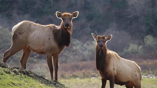
 
Two elk stand on a hill facing each other with their heads turned towards the camera.
Elk Monitoring

Long-term monitoring of the Roosevelt elk is essential to preserving the historical, cultural, and natural character of Lewis and Clark NHP.

A small brown bat with large ears hangs upside down in a corner with its face towards the wall
Bioacoustics Monitoring

Sound matters. Learn about soundscapes and the bioacoustic studies that help us understand the park's bats and migratory birds.

A woman in an NPS ballcap holding a plastic container with an aquatic organism in it
Dragonfly Mercury Project

The park participates in the national Dragonfly Mercury Project to understand mercury pollution risks within national parks.

Three park employees and interns stand around a quadrat and look at the plants and grasses in it.
Tidal Wetland Restoration

Learn how the park is contributing to the recovery of the Youngs Bay watershed and endangered salmon populations.

A person in NPS uniform tosses a small device connected to rubber tubing out into a body of water
Water Quality Monitoring

Clean water is crucial for the health of salmon and other aquatic life. The park and partners monitor the status of our rivers and streams.

Two people in bright reflective gear and park uniforms take measurements of a tree in the forest.
Forest Restoration

In 2002, 963 acres of former timber lands were added to the park. Learn how managers are restoring this rare coastal temperature rainforest.


Quick Reads

Showing results 1-10 of 17

    • Locations: Acadia National Park, Allegheny Portage Railroad National Historic Site, Amistad National Recreation Area, Apostle Islands National Lakeshore, Appalachian National Scenic Trail,
    • Offices: Air Resources Division, National Natural Landmarks Program, Natural Resource Stewardship and Science Directorate
    A person stands in a field looking at a bug through a magnifying lens.

    Read the abstract and get the link to a published paper on a model to predict mercury risk park waterbodies: Kotalik, C.J. et al. 2025. Ecosystem drivers of freshwater mercury bioaccumulation are context-dependent: insights from continental-scale modeling. Environmental Science & Technology. DOI: 10.1021/acs.est.4c07280

    • Locations: Lewis and Clark National Historical Park
    • Offices: North Coast and Cascades Inventory & Monitoring Network
    A recolored satellite image in bright red and blue shades showing areas of landscape disturbance.

    In early December 2007, a series of three Pacific storms struck coastal Oregon and Washington. Later named the “Great Coastal Gale of 2007,” these storms brought in heavy rains, severe temperature swings, and hurricane force winds exceeding 100 miles per hour to Lewis and Clark National Historical Park. Ten years later, the forest looks very different. How is the park using remote sensing technology to monitor landscape change?

    • Locations: Lewis and Clark National Historical Park
    • Offices: Inventory and Monitoring Division, North Coast and Cascades Inventory & Monitoring Network, North Coast and Cascades Research Learning Center
    Close-up image of leafy green moss and papery grey lichens.

    At Lewis and Clark National Historical Park, staff are developing a plan that will help restore the park’s degraded prairies, wetlands, dunes, and coastal forests. To better tailor this ongoing restoration effort, they needed to know more about the species that reside in the park, including bryophytes and lichens.

    • Locations: Hopewell Culture National Historical Park, Hopewell Furnace National Historic Site, Horseshoe Bend National Military Park, Hot Springs National Park, Hovenweep National Monument,
    • Offices: Appalachian Highlands Inventory & Monitoring Network, Arctic Inventory & Monitoring Network, Central Alaska Inventory & Monitoring Network, Chihuahuan Desert Inventory & Monitoring Network, Cumberland Piedmont Inventory & Monitoring Network,
    A toad sits on red sand, looking into the camera.

    To steward amphibians effectively, managers need basic information about which species live in parks. But species lists need constant maintenance to remain accurate. Due to recent efforts, the National Park Service now has an up-to-date amphibian species checklist for almost 300 parks. This information can serve as the basis for innumerable conservation efforts across the nation.

    • Locations: Lewis & Clark National Historic Trail, Lewis and Clark National Historical Park
    • Offices: Archeology Program
    Petroglyphs in stone

    Members of the Lewis and Clark Expedition, also known as the Corps of Discovery saw petroglyphs and pictographs along their route. Sometimes, Native peoples interpreted the markings for the corps members. Other times, the corps members encountered markings that appeared abandoned, with no recent tribal association, and their significance was left a mystery.

    • Locations: Lewis and Clark National Historical Park, Mount Rainier National Park, North Cascades National Park, Olympic National Park
    A lush green forest with large, moss-covered trees, and ferns

    Despite dire evidence of rising tree death, researchers found resilience and hope deep inside western Washington's forests. But it will take 21st-century monitoring methods to keep that hope alive.

    • Locations: Lewis and Clark National Historical Park, Mount Rainier National Park, North Cascades National Park, Olympic National Park, San Juan Island National Historical Park
    • Offices: North Coast and Cascades Inventory & Monitoring Network, North Coast and Cascades Research Learning Center
    A hand holds a paper sample envelope in front of a forest stream.

    SEPTEMBER 2023 – Over two years, teams at four parks in the North Coast & Cascades Network hiked hundreds of miles to collect samples of environmental DNA (eDNA) from park waters. These delicate samples promise to greatly expand our understanding of aquatic ecosystems, answering important questions about threatened species, emerging pathogens, ecological invaders, and more. What's next for this project?

    • Locations: Lewis and Clark National Historical Park, Mount Rainier National Park, North Cascades National Park, Olympic National Park
    • Offices: North Coast and Cascades Inventory & Monitoring Network, North Coast and Cascades Research Learning Center
    Woman stands in a forest writing on a clipboard

    JANUARY 2023 – Pacific Northwest forests are vital living systems, cycling huge quantities of carbon and nutrients, filtering pollutants from waterways, and serving as a living bulwark against climate change. However, forests worldwide are threatened by increasing warming and drought, leading to tree die-offs. A new study asks the question: Is this pattern playing out in the mature and old-growth forests of western Washington?

    • Locations: Cabrillo National Monument, Channel Islands National Park, Golden Gate National Recreation Area, Lewis and Clark National Historical Park, Olympic National Park,
    • Offices: Natural Resource Stewardship and Science Directorate, Ocean and Coastal Resources Branch
    Collage of different rocky intertidal creatures photographed against a white background.

    Ocean acidification (OA) is a huge threat to marine life. But it is hard to track remotely on a large scale. So this summer, seven West Coast national parks are teaming up with the 2021 NOAA West Coast Ocean Acidification Cruise. They’ll collect water samples in-person to check several OA indicators. Their data will help paint the most detailed picture yet of OA conditions up and down the coast, from parks’ rocky intertidal zones to dozens of miles offshore.

    • Locations: Fort Vancouver National Historic Site, Lewis and Clark National Historical Park
    • Offices: National Historic Landmarks Program
    Two people digging and sifting through soil in search of artifacts.

    While the site of Fort Astoria in Oregon has been listed as a National Historic Landmark (NHL) since the 1960s, archaeologists had never performed methodical excavations at the site. In 2020, the regional NHL program published a report from an archaeology field school that detailed three archaeological sites associated with the NHL. This work greatly expanded our understanding of the fur trade and its aftermath at the mouth of the Columbia River.


Published Science Reports

 
Graph showing an increase in the projected average annual temperature for two climate futures.
Lewis and Clark Climate Futures Summary

Temperatures are currently rising in Lewis and Clark at 2.3°F per century. This 2024 report outlines what climate futures mean for the park.

A blue and black colored map showing higher acoustic levels near developed areas
Natural Resource Condition Assessment

This 2020 report details the status and trends of Lewis and Clark's natural resources—from lampreys to night skies to coastal forests.


The NPS DataStore archives studies and reports by park scientists or produced in collaboration with the NPS. Some reports below are part of the NPS Natural Resource Report Series or Science Report Series and are only published in the DataStore. Explore scientific journals and databases to find studies by researchers unaffiliated with the park.
To learn more or request information, please contact the North Coast & Cascades Research Learning Center.

Source: Data Store Saved Search 5325 (results presented are a subset). To search for additional information, visit the Data Store.


Park Species List


Select a Park:

Select a Species Category (optional):

List Differences

Search results will be displayed here.


Visit NPSpecies for more comprehensive information and advanced search capability. Have a suggestion or comment on this list? Let us know.

 
Researchers bend over to examine rocks in the intertidal zone.
North Coast & Cascades Network

Learn how long-term ecological monitoring is used to track the health of Lewis and Clark and national parks across the Pacific Northwest.

Colorful oblique satellite image of the Puget Sound area.
North Coast & Cascades Science Days 2025

Join us for a three-day virtual symposium in February featuring science that spans parks, ecosystems, and fields of study.

A person operates a yellow surveyor's device in a forest.
Conduct Research in the Park

A permit is required for most scientific research activities in the park. Learn more and apply here.

Last updated: November 5, 2024

Park footer

Contact Info

Mailing Address:

Lewis and Clark National Historical Park
92343 Fort Clatsop Road

Astoria, OR 97103

Phone:

503 861-2471
Rangers are available to answer your calls between the hours of 9 - 5 PST.

Contact Us