|
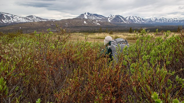
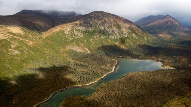
Hikers willing to navigate through extremely dense brush will reach secluded alpine tundra with endless ridgelines to explore in this hike between Fishtrap and Snipe lakes on the western edge of Lake Clark National Preserve. This page provides information to help you plan your trip. With four million undeveloped, wild acres to explore there are countless places go for adventure, solitude, and recreation in Lake Clark. Part of the purpose of the park is to allow for individual, personal exploration of wilderness; therefore, the only maintained trails are the Tanalian Trails near Port Alsworth. This page only describes the general terrain between Fishtrap and Snipe Lakes; it does not describe in detail the exact route you should walk. Instead, we encourage you to use the information provided to plan your own unique trip. This off-trail route can be expanded, linked with other routes, or simply used to get an idea of the terrain. Adventurers in Lake Clark will need to rely upon way-finding, map-reading, and trailless hiking skills to navigate, or hire a guide who can help. 
NPS Photo / Rebekah Jones MapsUSGS 1:63:360 series topographic Lake Clark C4 and B4AccessFly into Fishtrap Lake and out of Snipe Lake. A float or amphibious plane is required in order to land on these lakes in the summer, as neither have beaches suitable for a wheeled plane to land. Planes operating on wheels or skis may land on either lake in the winter if ice conditions are suitable.DistanceNo less than 10 miles. May be longer depending on the exact route you take.Time1-4 nights depending on how direct of a route you take and how much time you choose to spend exploring or relaxing.DifficultyStrenuous hiking through dense, tall brush with wet, uneven terrain at the lower elevations and near stream crossings. Gentle to moderate hiking through low brush and alpine terrain at the higher elevations.HighlightsSpectacular views of mountains and lakes as you hike along high, alpine ridgelines. Abundant blueberries, crowberries, and lowbush cranberries in season. It is less likely that you will encounter other people in this area than along the more popular routes that pass through Twin Lakes.HazardsMosquitoes and biting flies, dense brush at lower elevations, uneven and wet terrain, talus slopes, wildlife including moose, brown bear and black bear, several minor creek crossings, and one river crossing knee to thigh deep.Route DescriptionThis route may be hiked in either direction, or travelers may choose to fly in and out of the same lake.On the Fishtrap Lake side Get dropped off/picked up at the far northeast end of the lake. This lake does not have a rocky shoreline that is easy to walk along. The western edge of the lake has some private inholdings that should be avoided. The elevation here is approximately 1650 feet, and the brush is dense. Alpine terrain is reached at about 2300 feet. Head uphill due north for the most direct route to alpine. Be aware, you are hiking on a south-facing slope here and the brush in this area is extremely thick, well above head-high, and mixed with spruce and tussocks. Tussocks are mounds of vegetation usually one foot high or less and one to two feet wide that cover large areas of wet tundra. Imagine walking across a landscape covered by wet basketballs that you step on and between with dense willow and occasional spruce trees to navigate between and around. Hiking is extremely strenuous in this environment. It may take multiple hours to get above tree-line. Moose, black bear, and possibly brown bear use the area. Some blueberries grow here. On the Snipe Lake side Get dropped off/picked up at the far southern end of the lake. Snipe has a narrow rocky shore you can walk along if you choose to get dropped off elsewhere along the lake. The approach to alpine on this side is further than on the Fishtrap Lake side; however the brush is not as thick, as tall, nor as difficult to navigate through except at the creek crossings. One river crossing knee to thigh deep is unavoidable if you are going to reach alpine. Blueberries grow in abundance here. Alpine Many square miles of rolling mountains above tree-line lie between Fishtrap and Snipe Lakes. Here the route choices are endless. There are several ridge-lines with scarce vegetation that provide stunning views to explore, or you can dip down into the valleys and mountain passes to find water. Blueberry, crowberry, and lowbush cranberry grow in abundance. Caribou trails crisscrossing the mountain slopes make for easy walking. Though the caribou population in the area is now scarce you may encounter brown bear, black bear, and ground squirrels among other wildlife species. Campsites and Food StorageIt is unlikely that you will find a flat campsite clear of heavy brush and on a durable surface until you reach alpine on the Fishtrap Lake side. There may be some suitable areas for campsites along Snipe Lakes shoreline, otherwise you will also need to reach alpine on that side. Please follow leave no trace ethics and park rules and regulations when choosing campsites, storing food, and building campfires.You will need to store your food and toiletry items in approved bear resistant canisters during this trip due to the lack of trees to hang food where suitable camping is available. Canisters can be rented for free at the park visitor center in Port Alsworth. You should also cook at least 100 yards away from your camp to avoid an association made by the bear between your camp and your food. Set up camp away from bear trails and feeding areas (salmon-bearing stream banks). 
Backpacking in Alaska
Get acquainted with what makes backpacking in Alaska unique and familiarize yourself with these backcountry tips before you plan your trip. 
Fishtrap Lake to Snipe Lake Route Photos
Images taken from along the Fishtrap Lake to Snipe Lake Route. |
Last updated: February 20, 2019
