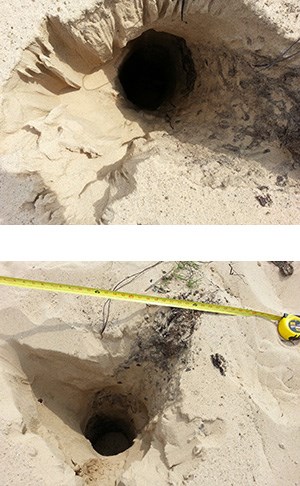
NPS Collection Brief summary of 2013 EPA Investigation A recent investigation by the United States Environmental Protection Agency (EPA) concerning the development of depressions and open holes in the Mt. Baldy (dune) at Indiana Dunes National Lakeshore, a unit of the National Park Service, established that ground‐penetrating radar (GPR) is a viable tool to image the stratigraphy of the dune. Specifically, the geophysical technique was capable of imaging to a depth of ~30 ft and recognizing a buried soil horizon that was an exposed part of the dune in the middle of the 20th century. The study also plotted known depressions/holes, and these features appeared to align themselves with the relict, buried southeastern‐sloping slip face of the dune that was similarly exposed in the mid‐20th century. The current working hypothesis is that natural (trees and brush) or anthropogenic (structures or debris) materials were buried by the rapid landward movement of the dune during the late 1900s. The age of the materials and the wet conditions during the spring of 2013 may have forced these materials to become unstable, collapsing and creating openings to the surface. 
NPS Collection Proposed Next Steps:
Proposed Approach:
TranscriptOn August 13th, 2013, Resource Management staff was probing at Mount Baldy to look for addition soft spots or holes. This is a soft spot. Staff also located this hole on Mount Baldy on the same day. There was some debris around the hole, but no visible debris in the hole. Samples were taken, and the spot was GPS’d so that we could return to the location. As you can see, down into the hole, it’s extremely deep, we were not able to measure how deep.
Visit our keyboard shortcuts docs for details
Discovering soft spots and holes located on top of Mount Baldy. Primary Investigators: Todd Thompson, PhD G. William Monaghan, PhD Erin Argyilan, PhD Charles Morris, PhD |
Last updated: September 13, 2021
