News Release
You are viewing ARCHIVED content published online before January 20, 2025.
Please note that this content is NOT UPDATED, and links may not work. For current information,
visit https://www.nps.gov/aboutus/news/index.htm.

|
Subscribe
|
Contact: Matthew Cahill, Public Information Officer, 907-697-2230
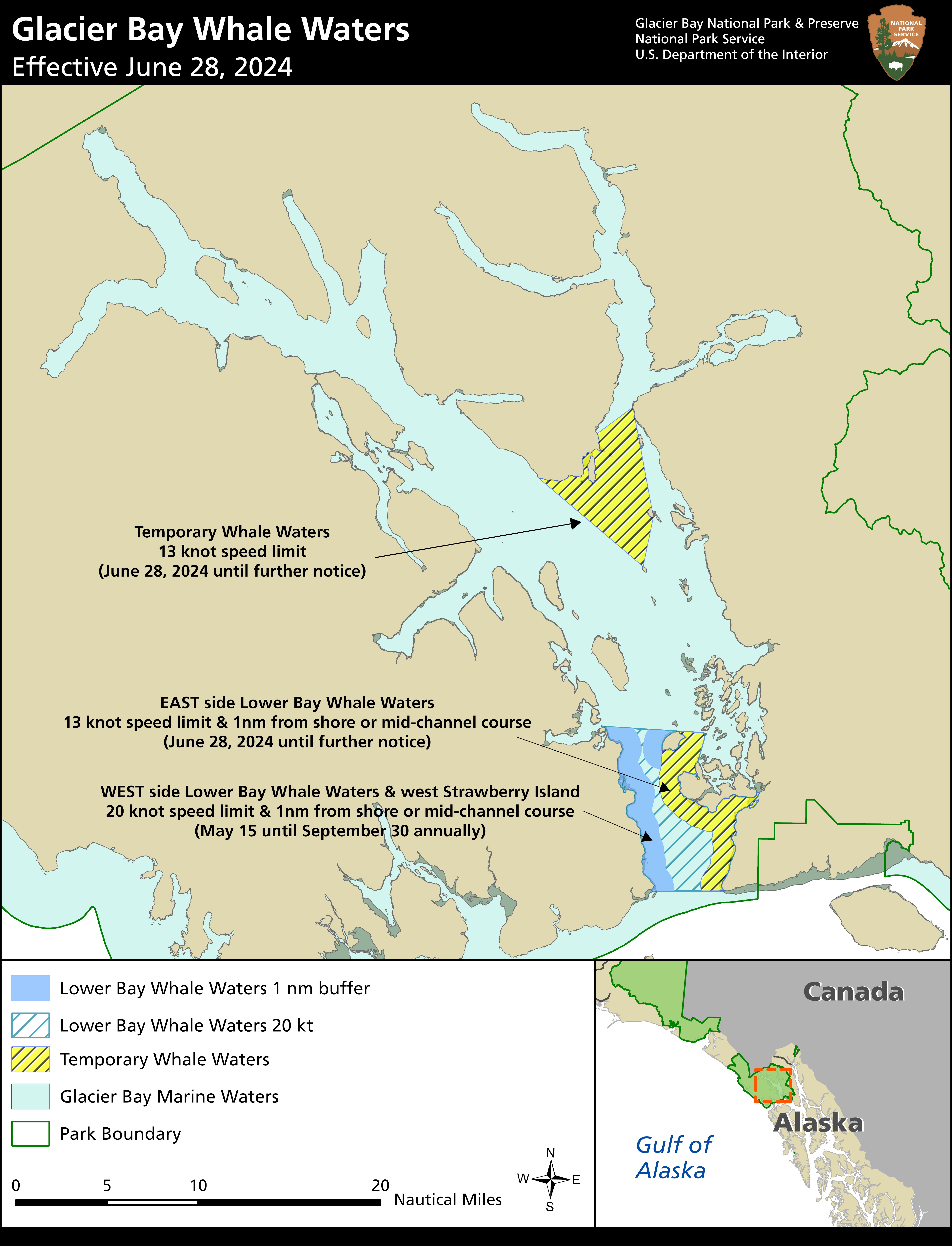
BARTLETT COVE, ALASKA – Glacier Bay National Park and Preserve Superintendent Tom Schaff announced today that a 13-knot vessel speed limit is being implemented in the eastern portion of Lower Bay whale waters. Recent sightings indicate that at least nine humpback whales, including a mother/calf pair, are feeding consistently in this area, putting them at risk of collisions with vessels. In addition, new temporary whale waters are being implemented in an area centered around Sebree Island to protect at least 16 whales that are feeding in this area, including two mother/calf pairs. All vessels in these temporary whale waters are required to travel at a speed no greater than 13 knots through the water. These updated operating requirements are effective from 5 AM Friday June 28th until further notice.Lower Bay whale waters changes:
- EAST SIDE only, as shown on map: A 13-knot vessel speed limit within 1 nautical mile of shore of Lester and Young Islands, including Bartlett Cove and Beardslee Entrance, and extending down the mainland to Point Gustavus.
- The rest of Lower Bay whale waters will retain a 20-knot vessel speed limit.
- In all Lower Bay whale waters, vessels over 18 ft in length are required to remain at least 1 nautical mile from shore or mid-channel.
- A 13-knot vessel speed limit in all waters bounded by:
- A line between the point of land west of Tlingit Point and the north tip of North Marble Island
- A line between the north tip of North Marble Island and the south tip of Sturgess Island
- A line between the south tip of Sturgess Island and Muir Point
- A line between Muir Point and the point of land west of Tlingit Point.
Last updated: June 27, 2024
