NPS Harbor Seal Population Monitoring Background 
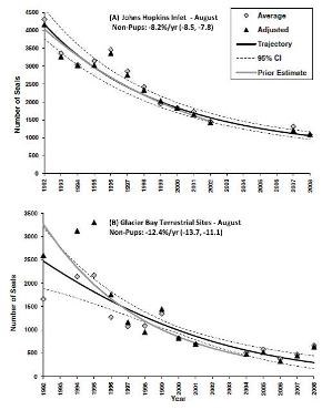
Declines of harbor seals in Glacier Bay are of concern for several reasons. First, harbor seals likely play an important role in structuring marine communities both as a consumer (e.g., Ward et al. 2012) and also as prey for other upper-trophic level species, such as transient killer whales (Orcinus orcas) (Williams et al. 2004). Second, harbor seals are a highly sought-after viewing experience for visitors to Glacier Bay (Womble & Gende 2010). Third, harbor seals have previously been managed as only three stocks in Alaska; however, based on genetics and telemetry data, NOAA Fisheries has recently designated 12 new harbor seal stocks in Alaska, one of which includes harbor seals in Glacier Bay and adjacent Icy Strait (Allen & Angliss 2012). Why count seals? 
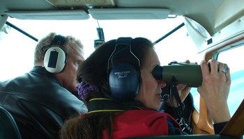
How do we count seals? Much of the aerial survey effort occurs in Johns Hopkins Inlet, an expansive tidewater glacial fjord in the upper West Arm of Glacier Bay that hosts the largest aggregation of seals in Glacier Bay and represents one of the primary pupping sites for harbor seals in Alaska. The aerial survey method, which was developed by the National Marine Mammal Laboratory-Polar Ecosystems Program (NOAA), involves conducting systematic transects and collecting digital images of seals using a high-resolution digital camera that is vertically mounted inside the plane's camera porthole. For each survey, approximately 1,250 non-overlapping digital images are collected. The images are then processed by digitizing and counting seals in each image. 
How is this information used?

Permits For Research |
Last updated: April 14, 2015
