|
Minimum Impact Hiking To keep the Denali backcountry in pristine condition for others, please take care in how you hike.
Terrain Challenges and Descriptions The backcountry of Denali may be very different from your other wilderness experiences. The trail-less terrain can present unique challenges to hiking and camping. There are five major terrain categories in the backcountry. Some afford fast, efficient travel; others are difficult and will limit your daily mileage. Jump to: River crossings | Glacier crossings | Gravel riverbars | Boreal forest | Brushy tundra | Alpine tundra | Glacial moraines 
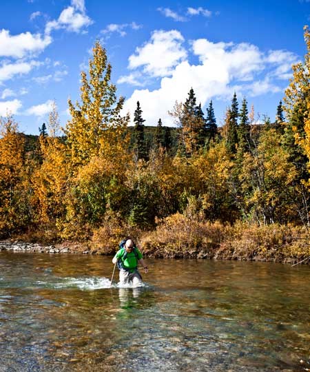
NPS Photo There are no bridges across rivers in the backcountry. You must negotiate your own river crossings and pack gear accordingly to keep dry in the event of an accidental swim. Water temperature is approximately 36º F (2º C), and a cold immersion may result in high risk of hypothermia. Try to cross where the river is braided and dispersed, rather than concentrated into a single deep, narrow channel. Due to the high silt content of rivers here, it is often difficult to ascertain the true depth of water. River depths can also vary widely during a trip, depending on rainfall and temperatures. Trekking poles or sticks can aid greatly in checking the river depth in glacial rivers, where the bottom is not visible. They can also help you keep your balance when crossing moving water. Glacial rivers generally run lower in early morning hours, so plan accordingly. Keep hiking boots on while crossing rivers to provide maximum protection for your feet and to give you traction on river bottoms. Accept wet boots. If you choose, you can bring an extra pair of shoes, to switch into while at camp. 
NPS Photo
Gravel River Bars As shown in the photo above, these flat, rocky surfaces characterize most major rivers in the park and provide fast, comparatively easy travel. Brush is usually minimal and therefore visibility is often greater than in other terrain. Most major river bars are located south of the Park Road, with their headwaters fed by glaciers at the base of the Alaska Range.
Crossing Glaciers Glaciers present numerous hazards and any form of glacier travel should be treated with respect and preparation. If planning a traverse over the upper ice and snow portions of a glacier, carry appropriate equipment, such as ropes, harnesses, ice axes, probes and crampons. Practice roped travel and know how to perform a crevasse rescue. If crossing the lower glacial moraine, be alert and use caution. While mountain climbing equipment is not required for this mode of travel, glacial moraines still present many potential hazards, such as debris slides, ice caves, swift rivers that run into crevasses, and uneven terrain. back to page top
Boreal Forest This terrain appears at lower elevations (less than 3,000' above sea level, generally) and consists of white and black spruce trees, as well as a mixture of birch, aspen and poplar trees. The ground vegetation is usually mossy and uneven. While boreal forests are not great terrain for camping, due to a lack of visibility, hiking in boreal forest is usually easy to moderate in difficulty. 
NPS Photo Bushy TundraTravel through some backcountry units, such as the Kantishna Hills, may require bushwhacking through dense brush. Willow and alder brush may exceed six feet (two meters) in height, and the thickness of brush often limits visibility. Extensive bushwhacking makes for slow and often frustrating travel; hikers must yell or talk loudly when bushwhacking to reduce the chances of a surprise encounter with wildlife. If it has rained recently, the brush can be extremely wet. You do not want to camp in thick brush, as visibility is often extremely poor.
Brushy tundra might only be knee high, or it might be over your head in areas, particularly along drainages. Staying out of those areas will help you see (and avoid) wildlife, and will be more pleasant hiking. In fall (which is early to mid August), much of Denali's brushy tundra turns brilliant red, orange and yellow. NPS Photo
Alpine Tundra Alpine tundra exists at higher elevations (generally above 3,000' / 914 m) and affords good, solid footing for fast, easy travel. Even though nearly every backcountry unit has alpine tundra, some units may require an initial extra effort to climb above the brush and/or forest. While it sometimes takes extra effort to reach alpine tundra, it is the easiest terrain in which to travel. Camping can be difficult in alpine tundra, because of the angles and slopes of hill and mountainsides, but it offers excellent visibility. 
NPS Photo / Alex VanDerStuyf
Glacier Moraines Glacial moraines are often denoted on maps by stippled areas. A moraine consists of ice covered with dirt and debris. While no technical gear is needed, this makes for extremely rough and time consuming travel and contains many hazards. return to page top |
Last updated: May 10, 2017
