The events of World War II transformed Kiska Island in the Aleutians into a cultural landscape that is truly unique on a global scale.
Photograph by Dirk H.R. Spennemann
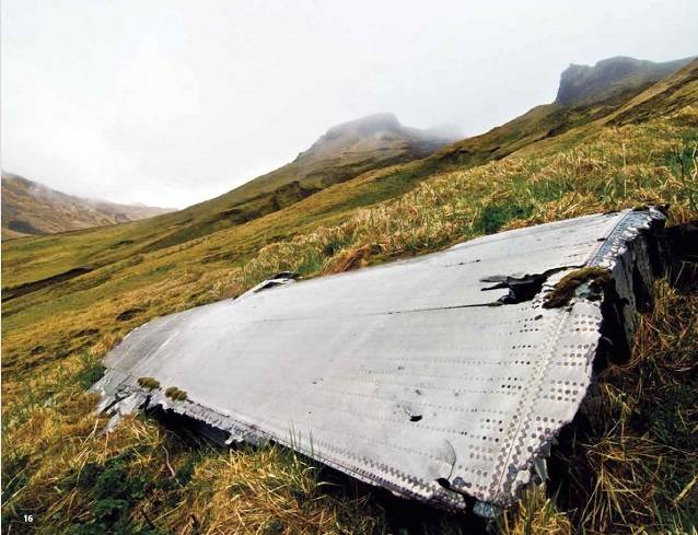
The verdant green of the tundra can not mask the many scars caused by a short-term, but very intense, military occupation, first by Japanese and later by U.S. forces. The Kiska battlefield, a National Historic Landmark since 1985 and part of the World War II Valor in the Pacific National Monument since 2008, is only one of two battlefields world-wide where neither previous nor later settlement obscure military developments. Through its integrity and excellent preservation, Kiska provides a unique, and evocative insight into the conditions under which the Aleutian Campaign was fought.
Kiska is an approximately 30-mile long and 7-mile wide (48 by 11 km) volcanic island of the Rat Island group of the Aleutian Chain, located approximately 1,450 miles (2,330 km) west of Anchorage. Kiska Harbor, on the eastern side of the island, is one of the few safe and sheltered harbors in the western Aleutians. Early human occupation is evidenced through the prehistoric sites on the island with some later occupation during the Russian period, that ended by 1812 (USFWS 2003). Today Kiska is uninhabited by people and is home to large sea-bird colonies. The lower reaches of the island are covered with tundra, while the upper reaches are covered with mossy vegetation, giving way to areas devoid of vascular plants. With the exception of the volcanic cone in the north, the landscape is dominated by undulating hills, intersected by deep drainage channels.
The Pacific War came to Alaska when Japanese carrier planes bombed U.S. installations at Dutch Harbor on June 3, 1942. Three days later, Japanese forces landed on and occupied Kiska and Attu Islands.
The initial Japanese landing on Kiska by an elite force of 550 men on June 6, 1942, met with little resistance by the sole island occupants, the ten men of the radio weather station. Along with equipment and supplies, the Japanese moved quickly setting-up anti-aircraft and coastal defense guns on North Head.
The following day, an American patrol plane spotted enemy ships in the harbor. Soon U.S. bombers were making regular 1,200-mile (1,930-km) runs from Umnak Airfield to Kiska, facing adverse weather and difficult navigation conditions. The Kiska Blitz had begun.
Over the following months, the Japanese expanded their presence, receiving additional personnel and equipment. A naval installation was established in Kiska Harbor, comprised of a submarine base and a sea plane base. Relocating all troops from Attu, the Imperial Japanese Army set up a 3,500 men strong presence protecting Gertrude Cove, a potential U.S. invasion beach south of Kiska Harbor. At the height of development, the Japanese had more than 7,200 men on the island.
American bombing efforts to oust the Japanese were boosted by the development of airfields closer to Kiska, on Adak and on Amchitka. The Navy’s torpedoing of a significant number of Japanese vessels left the garrison dependent on the supplies that could be transported by submarines. The American bombing runs, which dramatically increased prior to the U.S. invasion of Attu, disrupted the Japanese occupation efforts including their attempts to complete an airfield and to provide reinforcements. More than six million pounds of bombs were dropped on Kiska over the 14-month period.
With the U.S. forces successfully recapturing Attu on May 30, 1943, the Kiska garrison was isolated and became unsustainable. As U.S. and Canadian forces of more than 34,000 men prepared to invade Kiska, a Japanese evacuation fleet managed to slip through the fog, board the remaining 5,100 troops in less than one hour and escape without being detected. Within two weeks, the Allies poured ashore, sustaining substantial casualties by friendly fire, mines and booby traps. To deny the Japanese an opportunity of return, the Allies established camps by setting up Quonset and Pacific huts, tents, and frame structures, finished the runway and built two docks and a wharf. While the invasion marked the end of the Aleutian Campaign, the U.S. military maintained a firm presence on Kiska through the end of the war, abandoning the island in 1946.
Photograph by Dirk H.R. Spennemann
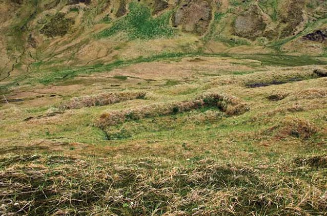
Even though the entire Kiska operation was planned and executed in less than three months, the Japanese Navy developed their base with great care. Sod cut from the surrounding tundra covered the roofs of barracks and staff buildings, and enveloped the high earthen walls that surrounded these buildings (Figure 2). This effectively insulated the occupants from the strong and occasionally bitter cold winds for which the western Aleutians are known. While these sod walls also provided some protection from bomb shrapnel, they played no role in camouflage (as is often suggested) as they show up very clearly on war-time aerial imagery.
Photograph by Dirk H.R. Spennemann
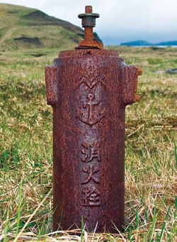
Throughout, extensive Japanese defenses, such as foxholes, personnel trenches and barbed wire entanglements can be found. In addition, a number of underground bunkers were dug into the hillsides. The Japanese established a network of roads connecting Kiska Harbor with Gertrude Cove, constructed a power and telephone network and erected a major Shinto shrine. But nothing illustrates better the Japanese desire to make Kiska a semi-permanent base than the installation of a system of fire hydrants (Figure 3).
While the Japanese development of Kiska was designed for semi-permanent occupation, the subsequent U.S. and Canadian presence on Kiska was based on the sole premise to merely deny the Japanese the opportunity to re-occupy the island. In consequence, the U.S. and Canadian establishments were built for short-term usage, with many of the tent sites and bases for Quonset huts erected in comparatively shallow revetments that provided little protection from enemy shrapnel or the winds. Like the Japanese, the Allies used small cast-iron solidfuel stoves for heating. Unlike the Japanese, however, who relied on dirt tracks in addition to their well-build roads, the U.S. forces erected a series of boardwalks that connected the barracks buildings, largely built in areas away from Japanese occupation sites and around numerous bomb craters that marked the landscape (Figure 4).
Photograph by Dirk H.R. Spennemann
The sheer size of the Japanese garrison, with about 3,700 Navy personnel at Kiska Harbor and some 3,500 Army personnel at Gertrude Cove (Romig 1944), resulted in a large number of barracks. In addition, the over 34,000 U.S. and Canadian troops that had landed on Kiska on August 15, 1943 also created temporary encampments, followed by a smaller number of permanent ones. As a result, the landscape is scarred by patches of bare soil clearly demarcating the location of the encampments.
Apart from a short period in the very beginning when Kawanishi H6K ‘Mavis” flying boats were stationed on Kiska, the Japanese air presence was provided by floatplane fighters (Nakajima A6M2-N ‘Rufe’) and floatplane bombers/reconnaissance aircraft (Aichi E13A ‘Jake’) all of which could use Kiska Harbor. While effective against U.S. bombers, the floatplanes were no match for fighter aircraft. As a result the Japanese began the development of an airfield on North Head, using manual labor in the absence of heavy earth moving equipment. Progress was slow, and the airfield remained largely incomplete at the time of the U.S. landings. The airfield was completed by U.S. forces soon after. Scattered on various parts of Kiska are the remains of U.S. bombers, flying boats and other aircraft shot down by the Japanese in the early days of the U.S. raids. Additionally, sections of Japanese float planes can be found in some of the material dumps created by U.S. forces after their landing.
Photograph by Dirk H.R. Spennemann
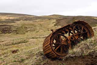
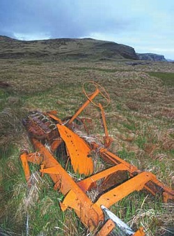
Both the Japanese and the U.S./Canadian occupation required a range of infrastructure and war material. Both forces landed a range of construction material, trucks and vehicles. Whereas the Japanese relied on a large number of lighters and small landing craft to ferry the supplies from the ships to the shore, the U.S. built two piers, remains of which are still extant. Abundant on the island today are the remains of damaged Japanese trucks (Figure 5), some even of American manufacture (under license). Most of these had been amassed by U.S. forces in two main ‘clean-up’ dumps, one located
at Kiska Harbor and one at Gertrude Cove. While U.S. trucks had been shipped back to other bases on Alaska and beyond once the U.S. occupation ended, researchers located some Canadian trucks that had been cannibalized for spare parts and dumped down a hillside. Elsewhere can be found stockpiles of coal, Japanese and U.S. lumber, and Marston matting (for the runway).
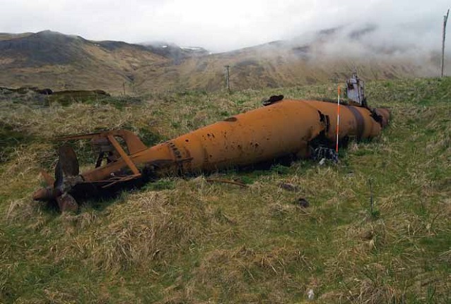
The strategic value of Kiska for the Japanese rested in Kiska Harbor serving as a base from which submarines and floatplanes could carry out sea patrols guarding the North Pacific approaches to the Japanese homeland. To this effect, a number of submarines were stationed there. The Japanese also built a slipway and repair facilities for midget submarines. At the time of their evacuation, three such submarines were left behind but irreversibly disabled through small explosive charges (Figure 6).
Photograph by Dirk H.R. Spennemann
The sustained U.S. air attacks damaged and sunk a number of Japanese vessels. Submerged cultural resources in Kiska Harbor consist of Japanese transports, flying boats and at least one submarine. The Japanese managed to run aground and thus salvage the cargo from five of the damaged ships. Their remains can still be seen in Kiska Harbor and Gertrude Cove.
Photograph by Dirk H.R. Spennemann
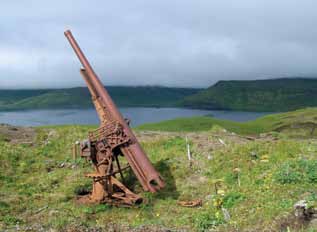
Some of the most evocative artifacts on Kiska are the various large guns that the Japanese had placed at strategic positions on the island. Japanese defense doctrine required defense against both air and naval forces. At the height of development, Kiska Harbor was surrounded by an array of light, medium (Figure 7) and heavy anti-aircraft guns. In addition, three batteries of coastal defense guns had been installed, two on North Head, and one on Little Kiska. These guns were all pre-World War I vintage and encompassed both Japanese and British-built weapons. The latter had come from British-built warships, which had been purchased by Japan at a time when their own naval architecture capability was not yet developed (Spennemann 1995).
The serial numbers of the breechblocks allow us to identify the vessels from which the British guns once came. These include the battleships Fuji (launched 1896) and Mikasa (launched 1902). Both vessels carry a very high level of significance in global naval history. The Mikasa was Admiral Togo’s flagship in the Battle of Tsushima in the Japanese-Russian War of 1905, a battle that heralded Japan’s arrival as a World Power. While the Mikasa survives as a museum ship in Japan, nothing remains of the Fuji. The gun on Little Kiska is the sole known survivor of the first battleship the Japanese had ordered at British shipyards.
Indeed, the Fuji represents the start of a long military and economic cooperation between Great Britain and Japan, which led to Japan siding with the Allies against Imperial Germany in World War I. As a result, Japan was awarded the former German colonies in Micronesia for administration. It was from these islands that many attacks on U.S. territories were launched in World War II, islands that had to be conquered by U.S. forces in several bloody battles (Kwajalein, Enewetak, Saipan, Peleliu). The global significance of the Fuji gun cannot be overrated. This single object can be used to interpret the history and politics of the Pacific region during first half of the twentieth century.
The events of World War II transformed Kiska Island into a cultural landscape that is truly unique. For over 120 years, up until WWII, there was little human activity on the island other than fur trapping. Kiska was then occupied by over 7,000 Japanese troops (Roethke 1944). After the end of the war Kiska was abandoned. Since no new development has taken place since that time, much of the military landscape remains. The only other WWII battlefields that can lay similar claims are El Alamein and other sections of the North African desert.
The resource surveys have found the environmental conditions produce circumstances that are very favorable to preservation: low UV due to near constant fog delays the decay of wood and rubber; removal of corrosion-conducive aerosols by rain and mist; and the containment of bacteria and other bio-decay by cold temperatures. Compared to other World War II resources in the Pacific (Look and Spennemann 1996), the heritage assets on Kiska are remarkably well preserved.
The uninhabited nature of Kiska and the concomitant uncontrolled visitation poses some management problems, such as the theft of small artifacts that will be need to be addressed as part of a management plan for the monument. Managing Kiska’s unique cultural landscape is a complex process with many agencies involved: Kiska is federally owned and forms part of the Alaska Maritime National Wildlife Refuge, which is administered by the Fish and Wildlife Service; Aleut archaeological sites are owned by or in the future be conveyed to the Aleut Corporation; all submerged cultural resources in Kiska Harbor fall under the jurisdiction of the State of Alaska; and, the National Park Service, through its Affiliated Areas Program and the NHL Program, provides ongoing technical assistance and guidance on historic preservation matters to all land managers involved. Future work by the NPS will see the revision of the existing NHL nomination of Kiska to include the U.S. and Canadian occupation. In the light of this assessment of Kiska, an in-depth examination of cultural resources on Attu seems highly desirable.
REFERENCES
Dowell, T. 1977.
Debris removal and cleanup study Aleutian Islands and Lower Alaska Peninsula, Alaska. Alaska District, U.S. Army Corps of Engineers. June 1977. Anchorage, Alaska.
Look, David W., and Dirk H.R. Spennemann. 1996.
In a Tropical Marine Climate: Conservation Management of Historic Metals. APT Bulletin 27 (1-2): 60-68.
Mobley, Charles. 1996.
Cultural Resource Investigations at Kiska, Little Kiska, and Semisopochnoi, Aleutian Islands. Report prepared for the U.S. Army Corps of Engineers, Alaska District.
Murphy, Larry E. 1990.
Contributions to Kiska Harbor Survey 1989: Preliminary Report. Draft. National Historic Landmark files, National Park Service. Anchorage, Alaska.
Roethke, William A.C. 1944.
Report of Facilities at NAAF Kiska, as of 1 July 1944. RG 181, Entry 83 Box 15 Folder C&S NB Facilities. National Archives and Records Administration, Anchorage.
Romig, Howard G. 1944.
Survey of Japanese medical facilities found on Kiska. NAAF Kiska, October 1943. Map enclosure. RG 181 Entry 83 Box 4 Folder A11 Investigations & Research. National Archives and Records Administration, Anchorage.
Spennemann, Dirk H.R. 1995.
Physical reminders of the British-Japanese Armament Trade in Micronesia. Journal of the Pacific Society 18 (3): 117-130.
Spennemann, Dirk HR. 2008.
The Present and Future Management of the Japanese Guns on Kiska I., Aleutians, Alaska. Conservation Management Plan. Study prepared for the US Fish and Wildlife Service, Alaska.
U.S. Fish and Wildlife Service (USFWS). 2003.
Notice of Inventory Completion. Federal Register 68 (230): 67205. (www.nps.gov/history/nagpra/fed_notices/nagpradir/nic0731.html)
Part of a series of articles titled Alaska Park Science - Volume 10 Issue 1: Connections to Natural and Cultural Resource Studies in Alaska's National Parks.
Last updated: August 8, 2024
