USGS photograph by W. Hildreth
Introduction
The explosive eruption of Novarupta on June 6-8, 1912, was the world’s most voluminous of the twentieth century and made the remote Katmai region famous. But Novarupta is hardly alone in the area. It is part of the Aleutian volcanic arc, the curving chain of volcanoes extending from southcentral Alaska to the far western end of the Aleutian Islands, and one of the most active volcanic regions in the world (Simkin and Siebert 1994). Geologic studies in the last two decades have identified more than 50 discrete volcanic vents in Katmai National Park and Preserve, less than half of which had been previously named. Most of these vents form a narrow line of ice-clad stratovolcanoes on the drainage divide of the Alaska Peninsula, which makes up the Aleutian arc segment that stretches from Mount Douglas to Peulik.
Twenty of the volcanic vents in the park are within 15 km of Novarupta (Hildreth and Fierstein 2000, Hildreth et al. 1999, 2000, 2001, 2002, 2003a, 2003b, 2004) . This unusually dense grouping around Novarupta, called the Katmai cluster, includes the four stratovolcanoes Mounts Katmai, Mageik, Martin, and Griggs; the cluster of volcanic vents called Trident Volcano; Snowy Mountain; the three ava domes Novarupta, Mount Cerberus, and Falling Mountain, and the extinct Alagogshak stratovolcano.
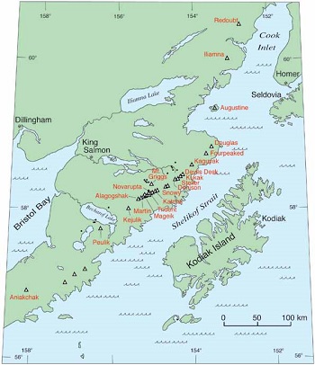
The Katmai cluster is still active, with fumaroles and steam vents on all of the stratovolcanoes but Alagogshak. The most recent eruptions were from a new vent on Trident Volcano (Southwest Trident, 1953-74), but ash deposits indicate that there have been at least eight other explosive events from the volcanoes of this area in the past 10,000 years. Activity continues in the northeast corner of the park as well, with steam explosions from Fourpeaked volcano in 2006, prolonged vigorous steaming coating snow-covered Kukak with yellow sulfur, and gas bubbling up through Kaguyak’s caldera lake. All of these rugged and active volcanoes contribute to spectacular scenery in this remote and sparsely inhabited wilderness on the Alaska Peninsula, ready for exploration by the adventurous and hardy. What follows is a brief geologic summary of some of the volcanoes in Katmai National Park and Preserve, an explanation of how geologists unravel a volcano’s eruptive history, and what that history can tell us about possible eruptions to come. We begin with an overview of Alaska’s volcanoes in a global context, as part of the “Ring of Fire”.
Ring of Fire
Volcanoes in the park and the Aleutian volcanic arc are part of the circum-Pacific “Ring of Fire”, a series of volcanic chains that ring the Pacific Ocean. This Ring of Fire marks the boundaries of the shifting plates that make up the earth’s crust. Great stress accumulates along these boundaries as the plates move under, over and past each other, and the resulting strain has long been linked to seismic and magmatic activity. These stresses continue today, which is why many volcanoes in in the park are quite active.
USGS photograph by J. Fierstein
Volcanoes of the Park: Long Histories —a Key to the Future
Understanding the eruptive history of a volcano provides the best clues as to when, how, and on what scale the volcano may erupt in the future. These histories are chronicles of past eruptions, pieced together using what we know about the lava flows and ash deposits that erupted throughout the volcano’s lifetime. Geologists unravel these volcano stories in detective fashion by mapping the distribution of lava flows and ash deposits, establishing the order of eruptive events, and using radiometric dating to determine the age of the rocks and ash deposits. Ash layers are distinguished from one another by geochemical fingerprinting. By determining their chemical compositions, ash layers can then correlated to their source vents by comparison with lava compositions. This information provides geologists with insights into the behavior of individual volcanoes, how often they erupt, and permits assessment of what types of volcanic hazards are most likely associated with them.
Geologic work in the last two decades has established eruptive histories for a number of the volcanoes in the park (Hildreth and Fierstein 2003, Hildreth et al. 2003b; Hildreth et al. 2004, Fierstein and Hildreth 2008). The histories are long in a human timeframe (some are more than one million years old), and many people are not used to thinking about events on that timescale. But geologists consider a volcano’s entire lifetime in assessing its eruptive history so as not to miss infrequent, but important, events. Most of the time volcanoes are quiet, punctuated only sporadically by short periods of eruptive activity. These active periods, although short on a volcano timetable, are typically decades to centuries long and can have a big effect on generations of humans.
The intermittent episodes of activity that built each of the Katmai volcanoes spanned years to centuries, and even millennia, and each episode included multiple eruptive events. Some episodes are dominated by small lava flows, and some include many separate events of ash ejection as well as lava-flow extrusions. Some lava extrusions travel far from their vents and make elongate lava flows, while other extrusions are short-traveled and pile up close to their vents to build lava accumulations called lava domes. Large explosive eruptions such as Novarupta are less common. They typically last only a few days but can be followed by weeks to years of lesser events (lava-dome extrusion, small-scale explosions, and continuing seismicity). The area that is now Katmai National Park and Preserve has produced a wide variety of volcanic activity.
Katmai Volcanoes
Recent work in the Katmai area has established an eruptive history for each of the Katmai cluster volcanoes and for Kaguyak volcanic center by mapping the distribution of eruptive products, and by describing in detail both lava flows and ash layers (Hildreth and Fierstein 2003, Fierstein 2007). Combined with the mapping, information about the ages of the deposits constrains the timing and frequency of past eruptions, which was used to make a volcano-hazard assessment for the Katmai cluster (Fierstein and Hildreth 2001). Brief descriptions of some of the better-studied Katmai volcanoes are summarized below.
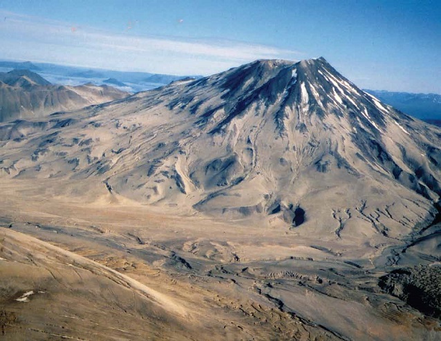
Mount Griggs, the tallest peak in the district, rises to 7,600 ft (2,530 m) in elevation on the eastern margin of the Valley of Ten Thousand Smokes (Figure 1). A relatively symmetrical cone, it has three nested summit craters and several small glaciers radiating from its summit. Mount Griggs is largely armored by young lava flows, but a few remnants of older lavas show that the volcano has existed for at least 290,000 years. Much of the volcano was built by dozens of overlapping lava flows between 85,000 and 10,000 years ago. Within the last 10,000 years, collapse of the southwest part of the volcano left a mile-wide amphitheater near the summit and shed a large debris avalanche (rapidly moving slide mass of rock and debris) into the river valley below. Subsequent andesite lava flows nearly filled this scoop-shaped depression and covered the southwest slope of the volcano with a fan of blocky lava flows. Small-volume lavas have characterized the activity of Mount Griggs for a long time, and the volcano has had no recognized large ash-fall-producing explosive events (Hildreth et al. 2002). Yellow sulfurous fumaroles discharging vigorously near its summit show the volcano is still active.
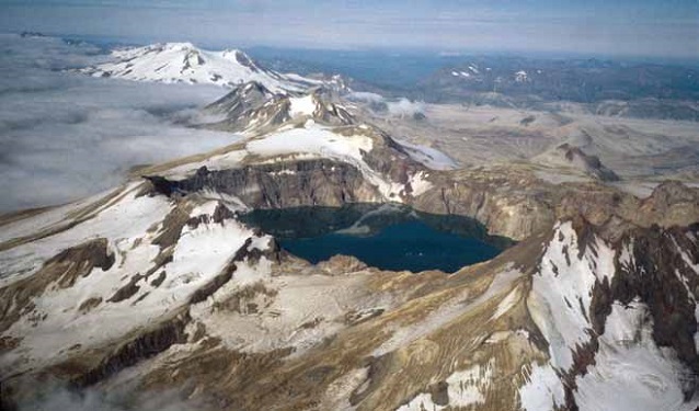
Mount Katmai, centered 6 miles (10 km) east of Novarupta, is a stratovolcano that once consisted of a pair of large cone-shaped volcanoes with interfingered lava flows. Both cones were beheaded by the caldera collapse of 1912 (Figure 3) (see previous article). The two cones of Mount Katmai had been active for more than 70,000 years. Thick stacks of lava flows and sequences of pyroclastic deposits from explosive eruptions are exposed in the caldera walls, products of at least 20 eruptive episodes. Mount Katmai has a varied volcanic history, erupting products with a wide compositional range (basalt to rhyodacite). One of the largest and most explosive events ever to occur at the Katmai volcanic cluster originated from Mount Katmai about 23,000 years ago. Rhyodacite pumice-fall and ash-flow deposits from the eruption were widely distributed, but have since been largely scoured away by glaciers. Remnants of the pumice fall preserved in nearby creeks are so thick that it seems likely the eruption was more voluminous than that of Novarupta in 1912. Since then, Mount Katmai erupted at least four more times, with both lava flows and ash falls. The largest of these is an explosive eruption thought to have occurred sometime between 16,000 and 12,000 years ago. Because pumice that fell near the vent landed on glaciers that occupied the valleys at that time, no undisturbed fall deposits remain near the volcano (Hildreth and Fierstein 2000, Hildreth and Fierstein 2003), but a fine ash layer on the Kenai Peninsula (225 km away) is probably equivalent (Reger et al. 1996, Fierstein 2007). It is clear that Mount Katmai has a history that includes more explosive eruptions than any of the other stratovolcanoes in the cluster.
USGS photograph by J. Fierstein
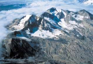
Trident Volcano (Figure 4) is a group of four overlapping stratovolcanoes and several lava domes as old as 150,000 years (Hildreth et al. 2003a). Although more deeply eroded by glaciers and in part older than adjacent Mageik and Katmai volcanoes, Trident Volcano produced the area’s most recent eruptive episode, from 1953 to 1974 (see Coombs and Bacon, this issue). The central and highest cone is considerably eroded and certainly inactive over the last 10,000 years, but nonetheless supports a vigorous field of sulfur-producing fumaroles on its lower southeast flank, first recorded in 1916 by botanist R.F. Griggs (Griggs 1922). Another fumarole, visible in 1951 aerial photographs as a 200-foot-wide steaming pit on the southwest ridge of the central cone, became the vent site for the new volcanic cone (Southwest Trident) that began to grow in 1953. In contrast to Mount Katmai, no large explosive deposits have come from any of the Trident peaks, although a few small remnants of pyroclastic-flow deposits south of the peaks are evidence of some minor explosive activity. Most of the eruptions of Trident Volcano have been lava domes and short-traveled blocky lava flows accompanied sporadically by small ash plumes.
USGS photograph by W. Hildreth
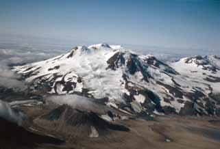
Mount Mageik, a compound stratovolcano just higher than 7,100 ft (2370 m), rivals Mount Katmai as the most extensive (80 km2) and most voluminous (30 km3) edifice in the Katmai cluster (Hildreth et al. 2000). Each of its four ice-mantled summits is a discrete eruptive center, and each is the source of numerous lava flows (Figure 5). Three of the eruptive centers are severely eroded by glaciers. They are each made up of sets of lava flows piled on top of each other that erupted during intervals 10,000 to 20,000 years long. Some of these lava flows are as old as 93,000 years, and eruptions at all three centers were long over by the time the fourth eruptive center began. The East Summit was the only part of Mageik built during the last 10,000 years. It erupted a dozen lava flows and seven explosive ash-fall-producing events, the youngest of which is about 4,000 years old. Because soil has developed on some of the lava flow surfaces but not on others in the sequence, it is likely that at least hundreds, if not thousands of years passed between eruptive episodes. The youngest Mageik eruption about 2,500 years ago was an explosion that formed a crater between two of the summits. Evidently, no magma erupted from this vent, but the crater is filled with a yellow-green acid lake that sends up curls of steam often mistaken for eruption plumes.
USGS photograph by W. Hildreth
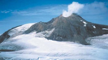
Mount Martin, just southwest of Mount Mageik, is a small volcanic cone and ten overlapping blocky lava flows that stretch northwestward for 6 miles (10 km). The cone is smaller than it seems, for although its summit exceeds 6,100 ft (2030 m) in elevation, it is built on a high ridge of much older sedimentary rocks.
NPS photograph by Lynn Fuller
Several ash-fall layers from Mount Martin are preserved in soils nearby and suggest that at least three eruptive episodes separated by 1,000 years to as much as several thousand years built Mount Martin between about 6,000 and 2,800 years ago (Fierstein 2007). Still active, the cone is marked by a persistent steam plume that coalesces from as many as 20 fumarolic jets that precipitate sulfur around a shallow lake on the floor of its 300-ft (100-m)-wide summit crater (Figure 6).
USGS photograph by W. Hildreth
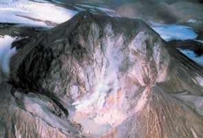
Alagogshak volcano, the southwesternmost member of the Katmai volcanic cluster, is marked by hydrothermally altered remnants of the summit crater of a severely eroded vent complex (Figure 7). Such rocks, when permeated by acidic hot water and gas from the volcano’s core, turn into colorful red, white, yellow and orange remnants rich in clay minerals. Lava flows extending as much as 6 miles (10 km) in most directions are all glacially ravaged. Alagogshak, oldest by far of all the Katmai cluster volcanoes, is made of lavas as old as 680,000 years and no younger than 40,000 years (Hildreth et al. 1999). This is the only Katmai cluster volcano that is no longer active.
USGS photograph by W. Hildreth
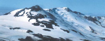
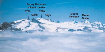
Snowy Mountain, the northeastern most volcano of the Katmai cluster, is largely ice-covered. It is made of a contiguous pair of small, deeply glaciated volcanic cones as well as a young lava dome that fills what was the summit crater for the northeastern one. Along the range crest, Snowy Mountain has three main summits, Peaks 6770, 7090, and 6875 (Figure 9). Only Peak 6875, the young dacite lava dome, is a vent. The other peaks are eroded remnants of lava flows from the two cones that are as much as 200,000 years old. The young lava dome sits in a scoop-shaped amphitheatre created by collapse of the upper part of the northeastern cone that had been weakened by persistent hydrothermal activity in the volcano’s core. The collapse produced a 22-km2 debris-avalanche deposit that came down in the last 1,500 years (Hildreth et al. 2001); the lava dome, therefore, is younger still.
USGS photograph by J. Fierstein
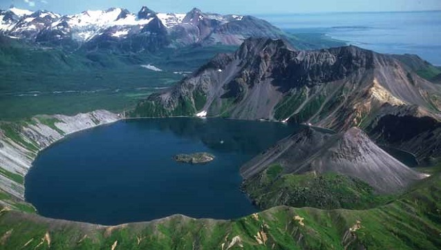
Kaguyak caldera in the northeast corner of the park is a steep-walled collapse caldera filled with a 500-foot (150-m)-deep lake that was created ~5,800 years ago in a large explosive eruption. Once thought to be a collapsed stratovolcano, recent work (Fierstein and Hildreth 2008) shows that ancestral Kaguyak was, instead, nine closely spaced but discrete clusters of lava domes. The domes, ranging from basalt to rhyolite in composition, are each stacks of short-traveled lava flows. Kaguyak is a good example of the episodic nature of volcanic activity. The earliest lava flows are as much as 300,000 years old. An especially active eruptive period between 60,000 and 30,000 years ago built five multi-component lava domes where the lake is now. All that activity was followed by a quiescent interval more than 20,000 years long. Then, about 6,000 years ago, another dome was extruded near the center of the cluster. This triggered explosions and culminated in the big event 200 years later that produced ash flows and falls, erupting enough magma that a 1.6-mile (2.5-km)-wide area collapsed to form the caldera, truncating the field of lava domes. Fine ash, largely winnowed out of the ash flows, is now found as a distinctive orange ash-fall layer (Fierstein) preserved widely in soils as far as the Valley of Ten Thousand Smokes, 50 miles (80 km) to the southwest. Some activity continued after the caldera-forming eruption, with emplacement of two more domes inside the new caldera that are now islands in the lake. Gas seeps still bubble up to the caldera lake surface, some with a strong sulfurous smell.
Aerial view of a snowy caldera
Volcanic Landscapes, Spectacular Parks
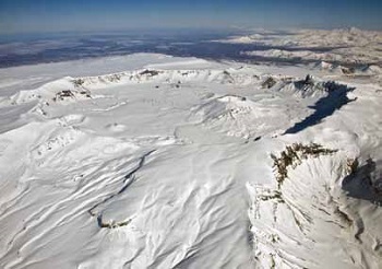
Volcanoes create spectacular and dynamic landscapes. The Valley of Ten Thousand Smokes so impressed Griggs that he urged President Wilson’s administration to preserve it for posterity, establishing Katmai National Monument in 1918. Created with the dual intention of protecting both the scenic wonders and preserving possibilities for continued scientific study of phenomena related to the 1912 eruption, the intent has been well fulfilled here. Expansion of the protected area and redesignation as a national park in 1980 validated and intensified both values. Clearly, the volcanoes of Katmai National Park and Preserve have provided geologists and other scientists with a range of possibilities for exploring and understanding volcanic phenomena. The compelling scenery and geology of other volcanic landscapes on the Alaska Peninsula and in the Aleutians have also been preserved in national parks and monuments. Among these are Iliamna and Redoubt Volcanoes in Lake Clark National Park and Preserve and Aniakchak caldera in Aniakchak National Monument (Figure 9). Much geologic work has already been done at Redoubt and Aniakchak (e.g., Coombs and Bacon, this issue). All three have been recognized as National Natural Landmarks (NNL) by the Secretary of the Interior and have been designated as nationally significant geological features. They are ready for the next generation of explorers and geologists.
References
Fierstein, J. 2007. Explosive eruptive record in the Katmai region, Alaska Peninsula: An overview. Bulletin of Volcanology 69: 469-509.
Fierstein, J., and W. Hildreth. 2001. Preliminary volcano-hazard assessment for the Katmai Volcanic Cluster, Alaska. U.S. Geological Survey Open-File Report 00-489.
Fierstein, J., and W. Hildreth. 2008. Kaguyak dome field and its Holocene caldera, Alaska Peninsula. Journal of Volcanology and Geothermal Research 177: 340-366.
Griggs, R.F. 1922. The Valley of Ten Thousand Smokes. National Geographic Society. Washington, D.C.
Hildreth, W., and J. Fierstein. 2000. Katmai volcanic cluster and the great eruption of 1912. Geological Society of America Bulletin [GSA Overview Paper] 112: 1594-1620.
Hildreth, W., and J. Fierstein. 2003. Geologic map of the Katmai Volcanic Cluster, Katmai National Park, Alaska. U.S. Geological
Survey Map I-2778, scale 1:63,360.
Hildreth, W., J. Fierstein, M.A. Lanphere, and D.F. Siems. 1999. Alagogshak volcano: A Pleistocene andesite-dacite stratovolcano in Katmai National Park. Geologic Studies in Alaska by the U.S. Geological Survey 1997. U.S. Geological Survey Professional Paper 1614: 105-113.
Hildreth, W., J. Fierstein, M.A. Lanphere, and D.F. Siems. 2000. Mount Mageik, a compound stratovolcano in Katmai National Park. Geologic Studies in Alaska by the U.S. Geological Survey 1998. U.S. Geological Survey Professional Paper 1615: 23-34.
Hildreth, W., J. Fierstein, M.A. Lanphere, and D.F. Siems. 2001. Snowy Mountain: A pair of small andesite-dacite stratovolcanoes in Katmai National Park. Geologic Studies in Alaska by the U.S. Geological Survey 1999. U.S. Geological Survey Professional Paper 1633: 13-34.
Hildreth, W., J. Fierstein, M.A. Lanphere, and D.F. Siems. 2002. Mount Griggs: A compositionally distinctive Quaternary stratovolcano behind the main volcanic line in Katmai National Park. Studies by the U.S. Geological Survey in Alaska, 2000. U.S. Geological Survey Professional Paper 1662: 87-112.
Hildreth, W., J. Fierstein, M.A. Lanphere, and D.F. Siems. 2003a. Trident Volcano: Four contiguous stratocones adjacent to Katmai Pass, Alaska Peninsula. Studies by the U.S. Geological Survey in Alaska, 2001. U.S. Geological Survey Professional Paper 1678: 1-28.
Hildreth, W., J. Fierstein, D.F. Siems, J.R. Budahn, and J. Ruíz. 2004. Rear-arc vs arc-front volcanoes in the Katmai reach of the Alaska Peninsula: A critical appraisal of across-arc compositional variation. Contributions to Mineralogy and Petrology 147: 243-275.
Hildreth, W., M.A. Lanphere, and J. Fierstein. 2003b. Geochronology and eruptive history of the Katmai Volcanic Cluster, Alaska Peninsula. Earth and Planetary Science Letters 214: 93-114.
Simkin, L., and T. Siebert. 1994. Volcanoes of the world. Geoscience Press. Tucson, AZ.
Reger, R.D., D.S. Pinney, R.M. Burke, and M.A. Wiltse. 1996. Catalog and initial analyses of geologic data related to middle to late Quaternary deposits, Cook Inlet region, Alaska. State of Alaska Department of Natural Resources, Division of Geological and Geophysical Surveys Report of Investigations 95-6.
Part of a series of articles titled Alaska Park Science - Volume 11 Issue 1: Volcanoes of Katmai and the Alaska Peninsula.
Last updated: October 26, 2021
