Lasting three days, the largest volcanic eruption of the twentieth century exploded June 6, 1912, from a new volcano, Novarupta. In the process, it created Katmai caldera and the Valley of Ten Thousand Smokes. Not only have the 1912 events remained scientifically important ever since, but also the 1912 deposits continue to provide insights about volcanic and magmatic processes that impact us and the land we live in.
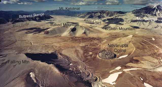
NPS Photo
Great Eruption of 1912, at Novarupta: The Exceptional Event
The magnitude and volume of the eruption at Novarupta in 1912 were exceptional, far larger than any other historical eruption in North America (Figure 2).
This fueled early U.S. Geological Survey and National Geographic Society scientific investigations that provided provocative perspectives and helped to shape thinking about volcanoes and magmas (Martin 1913, Griggs 1922). For the first time in recorded history, a great explosive eruption deposited its pyroclastic flows on land rather than in the sea (as at Krakatau in 1883), so that they could be studied in detail. It was also one of the few places where it was recognized that a wide range of magma compositions erupted together.
Rhyolite, dacite and andesite magmas (each containing different amounts of silica) swirled together to create white and black ‘banded’ pumice (Figure 3), an unusual occurrence that instigated debates about how these evolved together in the underground plumbing system. These unusual conditions and fascination with the “Ten Thousand Smokes” led President Wilson to preserve Katmai National Monument in 1918 for popular, scenic and scientific interest. Despite this attention, the eruption and its products remained poorly understood, owing in part to remoteness and difficult field conditions, but also because of a poor understanding of explosive eruptions in general and failure to identify the actual vent for the 1912 ejecta.
Many decades passed before Garniss Curtis (1968) established that the vent was Novarupta, not Mount Katmai as had previously been supposed. Early investigators Clarence N. Fenner and Robert F. Griggs mistakenly identified Mount Katmai as the vent for the eruption, because the near-vertical cliffs that surround the summit crater lake were fresh and glacier-free when first observed in 1916, and vigorous gas jets (fumaroles) ringed the caldera floor. Curtis’ work showed clearly that although Mount Katmai did collapse during the eruption, because most of the magma had been stored beneath it, almost all the magma vented at Novarupta 6 miles (10 km) away.
A magma chamber and caldera located so far from the erupting vent is highly unusual. Understanding the underground conditions or “plumbing system,” which enabled this, spurred debate that continues today. Over the last three decades, detailed studies of Novarupta deposits have contributed to a better understanding of how volcanoes work, how explosive pumice and ash erupt and are emplaced, how calderas collapse, and what happened at the vent during the 3-day eruption (Hildreth 1983, 1987, 1991, Fierstein and Hildreth 1992, Fierstein and Nathenson 1992, Fierstein et al. 1997, Hildreth and Fierstein 2000, Houghton et al. 2004, Fierstein and Wilson 2005, Hildreth and Fierstein 2012).
The “View from Afar” presented below is an overview of the eruption based on eyewitness reports and data recorded during the eruptions, all from a substantial distance. This is followed by “The Eruption Up-close”, a summary of events as they unfolded at and near the vent. Although no eyewitnesses could have survived near the vent, volcanologists pieced together what happened through detailed observations of the deposits left behind.
The unique combination of an eruption at Novarupta with collapse 6 miles (10 km) away at Mount Katmai provides an ideal opportunity for such studies. Nowhere else do young deposits from such a big eruption provide a geologic record up to the vent itself.
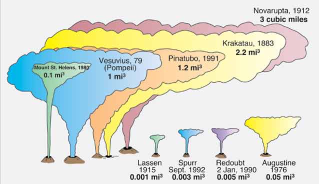
Graphic courtesy J. Fierstein
View From Afar
Initial signs of an impending eruption began with severe earthquakes felt at Katmai village on the Shelikof Strait coast “for at least 5 days prior to the eruption” (Martin 1913). More were felt on June 4 and 5, including as much as 160 miles (250 km) to the northeast, prompting the few inhabitants at Katmai village to evacuate by canoe down the coast toward Cold Bay (now Puale Bay). Unrest continued, as explosions were heard 140 miles (230 km) away on the morning of June 6. Not until 1 p.m. (Alaskan time) was the first towering eruption cloud witnessed by crew members of the steamer Dora, then in Shelikof Strait. Two hours later darkness abruptly enveloped the vessel as it was overtaken by the choking ash. Lightning flashed from the black cloud overhead as Captain McMullen changed course from the intended stop at Kodiak and headed toward the open Gulf of Alaska. Even “full steam ahead,” the Dora remained under the ash cloud until early the next day.
At Kodiak, 100 miles (160 km) southeast of the eruption center, the air became thick with ash and, for 60 hours, darkness was so complete that a lantern held at arm’s length could scarcely be seen. The terrified townspeople, some temporarily blinded by the sulfurous gas, crowded onto the U.S. Revenue Cutter Manning docked in Kodiak harbor, while one foot of ash (30 cm) smothered their town with three closely spaced periods of ash fall. The weight of the ash collapsed roofs in Kodiak; buildings were wrecked by ash avalanches that rushed down from nearby hill slopes; other structures burned after being struck by lightning from the ash cloud; and water became undrinkable.
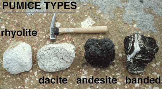
Courtesy of W. Hildreth
Effects of the ash were felt worldwide. From the vent at Novarupta, the towering column of ash, called a plinian eruption column, jetted skyward with little interruption for 60 hours.
Concurrently, it distributed ash flows that filled the Valley of Ten Thousand Smokes and fed a high umbrella cloud more than 1,000 miles (1,600 km) wide that shrouded most of southern Alaska and the Yukon Territory. Once the ash cloud had been sighted, it rapidly rose to a height greater than 100,000 ft (>30 km), where the jet stream carried much of it eastward. Strongly aided by winds blowing east-southeastward, ash fall began at Kodiak within 4 hours and by the next day had spread 625 miles (1,000 km) east and at least 60 miles (100 km) west.
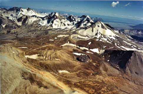
By midnight of the first day, 11 hours into the eruption, enough magma had escaped from beneath Mount Katmai that about 1.2 cubic miles (5 cubic km) of its summit collapsed. The collapse resulted in a 1.5-mile (2.5-km)-wide caldera, which has since accumulated a lake about 800 feet (250 m) deep (Figure 4). Caldera collapse was accompanied by 14 earthquakes of magnitudes 6 to 7, 100 shocks greater than magnitude 5, and countless smaller shocks (Figure 5).
By June 9, when the main outpouring finally ceased at Novarupta and the day dawned clear at Kodiak, the advancing ash cloud had begun dropping sulfur-permeated fallout on Puget Sound in Washington State. On the following day, the cloud passed over Virginia, and by June 17 it reached Algeria. Atmospheric effects (haze, smoke, red twilights) had been observed downwind, beginning in British Columbia on June 6, and in European locations two weeks later. The great quantity of ash and aerosol not only caused unusually brilliant sunsets, but, by shielding the sun’s rays, lowered average temperatures by about 2°F (1°C) in the Northern Hemisphere for more than a year.
Wind remobilization of the finest ash from the Valley of Ten Thousand Smokes during dry spells continues, a century later, to loft occasional dust clouds to elevations of thousands of meters.
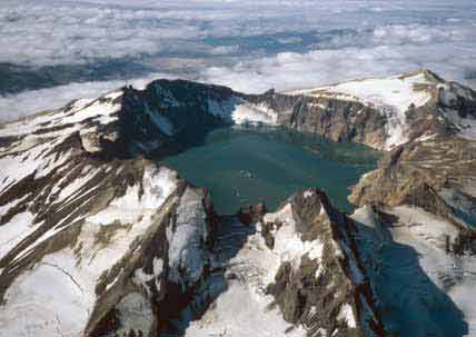
Courtesy J. Fierstein
The Eruption Up-Close
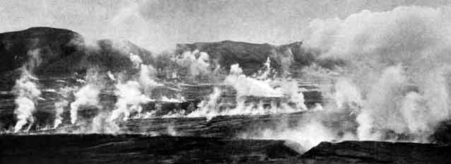
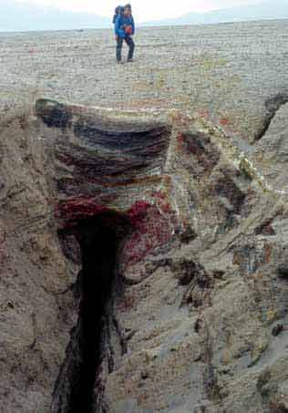
The 60-hour-long explosive sequence at Novarupta consisted of three discrete episodes (Figure 6), separated by lulls of at most a few hours duration (Martin 1913, Hildreth 1983, Fierstein and Hildreth 1992). During Episode I, the volume and rate at which the pumice and ash were ejected from the vent were so great that some of it went upward into the towering eruption column to be distrib-uted widely by regional and stratospheric winds and de-posited as ash fall (or, pyroclastic fall), while some flooded the vent area, flowing down the surrounding valleys and filling them as deep as 600 feet (200 m). These ash flows (or pumiceous pyroclastic flows, also called ignimbrites) remained hot for several decades, earning the name “Ten Thousand Smokes” for the many steaming cracks and fis-sures where surface waters that entered the hot ash-flow deposits were expelled as steam (Figure 7). Episode I left a 1.25-mile (2-km)-wide depression, filled with pumice and ash from its own eruption. Fault scarps caused by collapse and subsidence in 1912 encircle the area that provided the vent for the first day of eruption (Figure 8). Within this large ash-flow vent the subsequent eruptions bored through the partly consolidated deposits of Episode I, through a smaller vent that produced the ash falls of the next two days. These eruptions, Episodes II and III, also built a ring of pumice-rich ejecta around their smaller vent, which was plugged by the Novarupta lava dome that extruded after all the explosive activity was over.
In order to decipher what was happening at the vent on June 6-9, 1912, volcanologists look carefully at the surrounding deposits. The key to understanding these up-close events relies on being able to distinguish the three pumice types that make up the deposits: white rhyolite containing few mineral crystals, or phenocrysts; white to grey dacite with abundant crystals; and brown to black andesite, also with abundant crystals. Although ejected together throughout much of the eruption, their relative proportions varied with time. These variations were used to track the dispersal, character and thick-ness of each layer (first recognized and named Layers A through H by Curtis), both around the vent and in more distant locations, and that information was used to piece together what happened during those three days in 1912 (Hildreth 1983, Fierstein and Hildreth 1992).
Courtesy of the National Geographic Society
Episode I
Episode I began with widespread dispersal of purely rhyolitic fallout (Layer A) and synchronous emplace-ment of rhyolitic ash flows from the same high eruption column. After ejection of ~0.7 cubic miles (~3 km3) of rhyolitic magma over the course of a few hours, small amounts of andesitic and dacitic magma began contribut-ing to the eruption column, marking the onset of plinian Layer B (Figure 6). Pumice proportions in Layer B change from more than 99% rhyolite at its base to only about 15% at its top, matching the progressive shifts in (rhyolite/dacite/andesite) pumice proportions in the main sequence of ash-flow pulses, or packages, emplaced concurrently in the Valley of Ten Thousand Smokes (Fierstein and Hildreth 1992, Fierstein and Wilson 2005). By 0910 on June 7, ash-flow emplacement was over and ash fall stopped at Kodiak for a short time. Episode I lasted about 16 hours and produced almost all of the Valley of Ten Thousand Smokes ash flows (~2.6 mi3, 11 km3) and roughly half of the fall deposits (2.1 of 4 mi3, 8.8 of 17 km3).
Episodes II & III
Episodes II and III were similar to one another; each began after an eruptive lull, then erupted from a smaller vent nested inside the larger one of Episode I. Each deposited widespread fall layers (Layers C-D, and F-G, respectively), which were almost entirely dacitic. As with the preceding ash falls, Layers C and D were strongly dis-persed east-southeastward, but the wind relented and the subsequent ash falls were less strongly directed toward Kodiak (Figure 9). Layers E and H are largely accumula-tions of fine ash that settled regionally in the relative calm after each eruptive episode. Almost all of the deposits from these two episodes are widespread ash falls, but near the vent, short-traveled ash flows are preserved as well. Some of these, deposited from small explosions during the lull between the Episode II and III eruption columns, show the vent remained unsettled during this time.
Courtesy W. Hildreth
Three Lava Domes
The explosive episodes were followed by extrusion of three lava domes. Compared to the explosive violence of June 6-9, the growth of the domes was not much more than an afterthought of molten rock, largely rid of its former gas content, that slowly squeezed out of the vent. Though the exact timing is not known, these domes likely formed within days or as long as a year after the plinian events. One small dacite lava dome that plugged the Episode III vent was destroyed by small explosions; all that remains are lava blocks scattered atop Layer H (Adams et al. 2006). The same vent was plugged again by the rhyolitic Novarupta dome, which survives today. The third one is a dacite lava dome extruded on the floor of Katmai caldera, then partially disrupted explosively. Photographed by Griggs in 1916 and sampled by Fenner in 1923, it is now covered by the caldera lake.
Volcanological Significance of the 1912 Eruption
Many aspects of the three-day explosive eruption at Novarupta in June 1912 focused attention on this remote volcano, and it has become one of the most intensively studied in the world. Its eruptive volume of 3.1-3.4 mi3 (13-14 km3) of magma places it among the five largest in recorded history. At any time, such an eruption would attract much attention, but in 1912 the field of volcanology was in its infancy. Phenomena not previously seen or recognized anywhere else provided opportunities for a wide range of research. In addition to aspects already discussed, the eruption also led to pioneering studies in eruption dynamics and mechanisms of explosive eruptions, evolution of underground magma systems that produce volcanoes, and high-temperature vapor transport in fumaroles with relevance to metallic ore deposition.
USGS Photo
Investigations continue today, with recent work using state-of-the-art analytical instruments that measure things as small as bubbles of fluid trapped in individual crystals in pumices; these tell us how hot the magma was and at what depth it was stored before erupting (Coombs and Bacon, this volume). Other investigations consider a larger scale, like those that examine how seismic waves generated by earthquakes travel through subsurface areas beneath the volcanoes; these provide underground images of where and how magma is stored (Thurber et al., this volume).
Each new study uses previous work as a foundation. The focus on understanding the 1912 eruption and its products has led to significant advances in understanding volcanic and magmatic processes, what makes volcanoes erupt, and has changed the way scientists think about large explosive eruptions. The 1912 eruption has also provided opportunities for other types of research. Some have focused on the effects of the eruption on the surrounding environment, on flora and fauna, and on the people who lived there (see articles by Sherriff et al., Coletti, Jorgenson et al., Schaaf, and Partnow, this volume). Griggs’ (1933) prediction of rapid re-vegetation in years to come has not been realized in areas of thick ash inundation in and near the Valley of Ten Thousand Smokes, but where fallout was thin or eroded, plants recovered quickly. Although greenery is again lush in places where the accumulated ash was less than ~3 feet (1 m) thick, windswept ash-flow surfaces are still largely barren a century later. Today’s sparse vegetation provides little cover and meager food for the few animals that do venture into the Valley of Ten Thousand Smokes.
Novarupta, The Valley of Ten Thousand Smokes, and the Katmai volcanoes have been an open-air laboratory ever since Griggs’ time. Volcanological studies here have shaped how geologists think about explosive eruptions and continue to provide insights into a wide range of aspects about how volcanoes work.
References
Abe, K. 1992.
Seismicity of the caldera-making eruption of Mount Katmai, Alaska, in 1912. Bulletin of the Seismological Society of America 82: 175-191.
Adams, N.K., B.F. Houghton, S.A. Fagents, and W. Hildreth. 2006.
The transition from explosive to effusive eruptive regime: The example of the 1912 Novarupta eruption, Alaska. Geological Society of America Bulletin 118: 620-634.
Curtis, G.H. 1968.
The stratigraphy of the ejecta from the 1912 eruption of Mount Katmai and Novarupta, Alaska. In Studies in Volcanology, edited by R.R. Coats, R.L. Hay, and C.A. Anderson. Geological Society of America Memoir 116: 153-210.
Fierstein, J., and W. Hildreth. 1992.
The plinian eruptions of 1912 at Novarupta, Katmai National Park, Alaska. Bulletin of Volcanology 54: 646-684.
Fierstein, J., and M. Nathenson. 1992.
Another look at the calculation of fallout tephra volumes. Bulletin of Volcanology 54: 156-167.
Fierstein, J., B.F. Houghton, C.J.N. Wilson, and W. Hildreth. 1997.
Complexities of plinian fall deposition at vent: An example from the 1912 Novarupta eruption. Journal of Volcanology and Geothermal Research 76: 215-227.
Fierstein, J., and C.J.N. Wilson. 2005.
Assembling an ignimbrite: Compositionally defined eruptive packages in the 1912 Valley of Ten Thousand Smokes, Alaska. Geological Society of America Bulletin 117: 1094-1107.
Griggs, R.F. 1922.
The Valley of Ten Thousand Smokes. National Geographic Society. Washington, D.C.
Griggs, R.F. 1933.
The colonization of the Katmai ash, a new and inorganic “soil”. American. Journal of Botany 20: 92-113.
Hildreth, W. 1983.
The compositionally zoned eruption of 1912 in the Valley of Ten Thousand Smokes, Katmai National Park, Alaska. Journal of Volcanology and Geothermal Research 18: 1-55.
Hildreth, W. 1987.
New Perspectives on the eruption of 1912 in the Valley of Ten Thousand Smokes, Katmai National Park, Alaska. Bulletin of Volcanology 49: 680-693.
Hildreth, W. 1991.
The timing of caldera collapse at Mount Katmai in response to magma withdrawal toward Novarupta. Geophysical Research Letters 18: 1541-1544.
Hildreth, W., and J. Fierstein. 2000.
Katmai volcanic cluster and the great eruption of 1912. Geological Society of America Bulletin [GSA Overview Paper] 112: 1594-1620.
Hildreth, W., and J. Fierstein. 2012.
The Novarupta-Katmai Eruption of 1912: Largest Eruption of the Twentieth Century. Centennial Perspecitves. U.S. Geological Survey Professional Paper 1791.
Houghton, B.F., C.J.N. Wilson, J. Fierstein, and W. Hildreth. 2004.
Complex proximal deposition during the plinian eruptions of 1912 at Novarupta, Alaska. Bulletin of Volcanology 66: 95-133.
Martin, G.C. 1913.
The recent eruption of Katmai volcano in Alaska. National Geographic Magazine 24: 131-181.
Part of a series of articles titled Alaska Park Science - Volume 11 Issue 1: Volcanoes of Katmai and the Alaska Peninsula.
Last updated: October 26, 2021
