Introduction
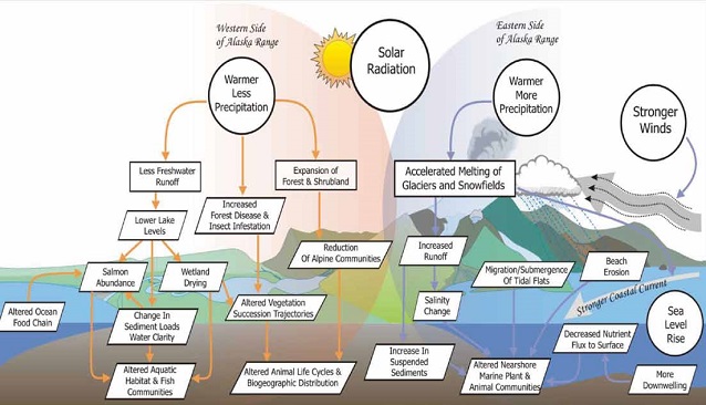
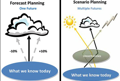
Changing climatic conditions are rapidly impacting environmental, social, and economic conditions in and around National Park System areas in Alaska (Figure 2) With over 50 million acres of parklands to administer, Alaska park managers need to better understand possible climate change trends to better manage arctic, subarctic, and coastal ecosystems and human uses of these areas. National Park Service (NPS) managers have been exploring scenario planning as an alternative approach for science-based decision-making in the face of an uncertain future. With the magnitude and effects of climate change uncertain across various parts of Alaska, scenario planning allows us to develop and test decisions under a variety of plausible climate futures that are grounded in the most current science. Scenarios are not forecasts, but offer a range of possibilities for the future, providing a framework for recognizing and adapting to change over time (Figure 3). Climate change scenarios will help prepare Alaska park managers for looming changes, to make informed decisions with the least regrets for future outcomes.
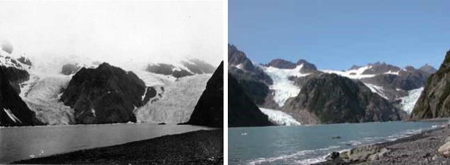
USGS photographs by Bruce F. Molnia
NPS and the University of Alaska Fairbanks Scenarios Network for Alaska Planning (SNAP) are collaborating on a three-year project to help Alaska NPS managers, adjacent landowners, and key stakeholders to develop plausible climate change scenarios for all NPS areas in Alaska. Final products will include climate change scenario planning exercises and reports for all the NPS units in Alaska, with efforts organized around each of the four NPS Inventory and Monitoring (I&M) networks.
Scenario planning is a well tested tool with business and government applications for a number of important questions, including the implications of climate change (Schwartz and Randall 2003). The NPS has worked with the Global Business Network (GBN), an international leader in scenario planning, and other partners to tailor the scenario planning process for climate change in and around parks. While the basic scenario planning process remains similar to each other, the results are as unique as the areas on which they are focused. This article summarizes the process using examples from a workshop focused on southwestern Alaska.
Stage one in this project was a training workshop on climate change scenario planning in August 2010, facilitated by GBN. Participants learned how to develop scenarios based on frameworks of critical uncertainties, and then fleshed out the beginnings of scenarios for two pilot parks, Kenai Fjords National Park and Bering Land Bridge National Preserve. Webinars were held weekly before the workshop to orient trainees to the scenario-building process, climate projections, and associated climate effects. The training workshop included key personnel with NPS parks and I&M networks in Alaska, NPS Climate Change Response Program staff, major adjacent area land managers, SNAP and climate change scientists.
Two climate change scenario planning workshops were recently completed in Anchorage, Alaska. The first one occurred in February 2011 and addressed park areas in the Southwest Alaska Network (SWAN), which includes Kenai Fjords, Katmai, Lake Clark, Aniakchak, and Alagnak. Draft summary results of this workshop are provided in this article. The second workshop addressed two parks along the northwestern coast of Alaska, Bering Land Bridge and Cape Krusenstern, and was completed in April 2011. Participants included representatives from the parks in question, NPS staff from the Anchorage office, UAF-SNAP personnel, and key individuals from other agencies, businesses, and com-munity stakeholders in the region. Thirty-four individuals contributed a wide range of perspectives and expertise to the inputs and outcomes of the SWAN workshop, and 26 individuals participated in the second workshop.
Courtesy of Global Business Network
Summary of the SWAN Workshop Process and Results
Preparations
A reading list provided to participants suggested advance reading of two books and a paper: “Beyond Naturalness” (Cole and Yung 2010); “The Art of the Long View” (Schwartz 1996), and “Understanding the Science of Climate Change – Talking Points Impacts to Alaska Maritime and Transitional Zones” (Jezierski et al. 2010). Before the workshops in Anchorage, participants took part in three pre-workshop webinars. These webinars covered: an introduction to scenarios planning; overview of Alaska climate change scenario drivers appropriate for the SWAN network area; and potential climate change effects, based primarily on reviews of published literature. The webinar presentations that are available on a webpage (Fresco 2011) include: SNAP projections for temperature, precipitation, thaw date, freeze date, and season lengths in the affected areas at various times into the future; climate change driver tables; and effects tables.
Summary
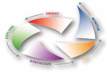
The workshop began with a plenary session on the fundamentals of scenario planning. Scenarios are intended to be stories of divergent yet plausible, relevant, and challenging futures that stretch thinking and provide a tool to navigate change. Scenario development involves five steps: orient, explore, synthesize, act, and monitor (Figure 4).
Courtesy of UAF-SNAP
Orient
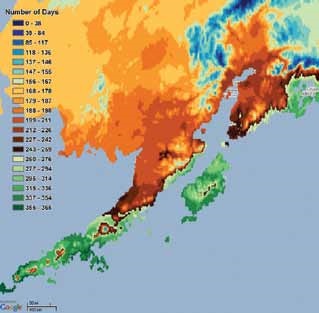
In step one, participants considered strategic issues that were framed in focal questions: “How can NPS managers best preserve the natural and cultural resources and values in their jurisdiction in the face of climate change?” and, “How will climate change effects impact the landscapes in which management units are placed over the next 50 to 100 years?” For the second focal question, participants considered the SNAP climate projections for temperature, precipitation, and freeze dates or unfrozen seasons (see Figure 5 for an example of model output). These model outputs were generated based on the average of five global circulation models used by the Intergovern-mental Panel on Climate Change (IPCC). SNAP selected the best-performing climate models for Alaska. Learn more about SNAP methods.
Explore
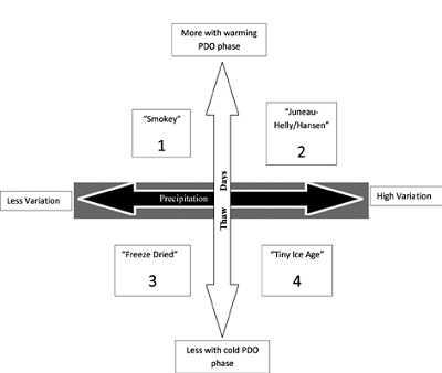
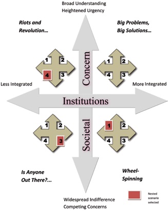
In step two, participants discussed critical forces of climate change that could affect parks (Figure 1). Critical forces, in this case, projected climate variables, were prioritized based on having high impact and uncertainty. Participants then divided into two groups, to explore and select two critical climate variables to frame into a scenario matrix, producing four futures (Figure 6). In the next stage of the workshop, each group nested the four climate futures in a matrix representing varying degrees of public concern and of institutional involvement with climate change, producing 16 futures (Figure 7).
Synthesize
In step three, participants selected three to four scenarios from the 16 futures to turn into descriptive narratives. Scenarios were selected based on the criteria of being: Plausible, Relevant, Divergent, and Challenging. From each scenario, participants identified a set of implications or “effects,” which were drawn both from the effects tables discussed during the webinars and the participants’ professional and personal experiences. Following this the implications and potential consequences were folded into a narrative.
Act
Groups then outlined future actions appropriate to each selected scenario. These potential actions formed the initial part of step four. The next part of step four was to identify “no regrets” actions; that is, actions that could provide substantial mitigation or adaptations to all potential futures. The final step in the process will be to monitor effects of actions over time and continue to validate the scenarios, adjusting action strategies, as needed.
This process is summarized for the SWAN riverine group. The group explored “climate drivers” for the bioregion (Figure 8) and also considered other critical drivers such as: volcanic eruptions (local acidification); major climatic cycles – Pacific Decadal Oscillation (PDO), Arctic Oscillation (AO), and Jet Stream changes; and variable stream flows. They ultimately selected two from the following short list of climate drivers: precipitation (variability), temperature (variability), thaw days (more or fewer), and PDO (warm/cold phase shifts). They refined their list to just thaw days (more or fewer days above freezing) and precipitation (low/high variation). PDO effects (multi-year cycles of warming and cooling) were combined with thaw days, creating a cool phase PDO with fewer thaw days and a warm phase PDO with more thaw days to push extreme possibilities.
The group then described the conditions that would likely result from each of the four combina-tions of thaw days and precipitation (Figure 6), and assigned a descriptive name to each scenario.
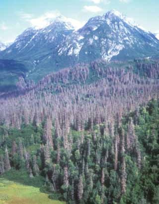
1. The climate scenario from the upper left quadrant of Figure 6, named “Smokey”, would be expected to result in the following environmental conditions: drought stressed vegetation; increased incidences of disease and pests; longer growing season; maximum shrub expansion (with less overland access); long-term reduction in stream flows; initially higher stream flows from seasonal glacial melt; reduction and eventual loss of glaciers; long-term reduction in stream flows; increased fire on the landscape; fewer salmon fry surviving due to their smaller size; more difficult access by waterless water with warmer and drier conditions, and less precipitation so barge transports on Naknek Lake and Lake Clark are reduced; fewer biting insects; decreased waterfowl; exposure of cultural resources; lowering of groundwater tables; more fugitive dust from mining should a Pebble Mine be developed; increased competition for water; use; and decreased subsistence travel over water and snow (Figure 9).
2. “Juneau /Helly Hansen” is the climate scenario from the upper right quadrant of Figure 6 and would be expected to result in the following environmental conditions: increased rain on snow events (increased flooding); thicker vegetation; increased erosion; increased lightning; increased evaporation (soil drying); more berries (good habitat for bear, moose, caribou); decreased area of alpine tundra; arrival of black bear; increases in waterfowl; increased impacts to park infrastructure; decreased backcountry use (due to rain and reduced flying days); increased hurricanes; decreased salmon production due to flooding; in-creased contamination due to runoff events; increased avalanches (Figures 11-12).
3. “Freeze-Dried” is the climate scenario from the lower left quadrant of Figure 6 and would be expected to result in the following environmental changes: persistent permafrost; decreased productivity of plants and berries, with associated wildlife impacts; continu-ing overland access; intensified competition for water resources between communities and mining; stable facilities and infrastructure; slow retreat of tundra ponds; extension of the range of Dall sheep; stable lichen ranges support caribou; high wind potential develops; and brown bear populations decrease (Figure 13).
4. “Tiny Ice Age” is the climate scenario from the lower right quadrant of Figure 6 and would be expected to result in the following environmental conditions: stable to larger glaciers; viable winter travel access; moderate pests and diseases and extreme weather events that may impact salmon (Figure 14).
Nested Scenarios
Each of the four climate scenarios described above were nested within a larger social/institutional framework (Figure 7). This framework explored how each story might play out in a world with greater or lesser degrees of societal concern and institutional commitment. We altered the GBM framework slightly, redefining the horizontal axis as “institutional” rather than “governmental”, and at national, state, and local scales rather than at national and international scales. Because 16 scenarios present far too many possible futures for anyone to fully consider, the riverine group selected the three scenarios highlighted in red. One of those is described below as an example.
The following is one example scenario that includes future implications, important management actions, research and information needs. A descriptive narra-tive was also developed to illustrate how the scenario could affect people and managers. It is important to reiterate that a scenario is not a prediction, but rather an assessment of what could result if the conditions defined by the scenarios matrix were to occur.
Nested Scenario 3 “Freeze-Dried” is framed in a social context referred to as “of riots and revolution.” The po-tential future implications under the conditions described for this scenario included numerous changes to natural, cultural, and subsistence resources, socioeconomics, and facilities. This scenario differed from the others in that salmon resources could be severely decreased, plant vegetative growth would be limited, and significant economic and cost of living issues would occur.

This scenario would result in cool and dry conditions with less water, yielding poor conditions for salmon reproduction, less snow, and large shifts in wildlife distributions and populations. Historical and archeo-logical resources would not be seriously affected, but conflicts could increase between subsistence, sport, and commercial user groups regarding access, seasons, and allocations for increasingly limited resources. Access over snow and river would be reduced, making access for local area residents limited and difficult. Fewer locals would retain their commercial fishing permits, with rising cost of living, and increased fuel costs. High governmental deficits, inflation, and less funding for land management would further impact rural communities. Coupled with an increased cost of living would be a reduction in fish and wildlife resources for subsistence, resulting in more rural residents moving to urban and regional population hubs. Local communities would suffer a loss of traditional values and behaviors including diminished sharing and the use of Traditional Ecological Knowledge. The dry conditions would increase the risk and occurrence of wildland fires, but most facilities would not be severely damaged.
Important management actions would include intensive management of fish and wildlife resources. Federal harvest preference for local rural residents would be triggered. Current and future critical habitats for fish and wildlife would be protected, including migration routes, breeding grounds, and ecosystem services. A more flex-ible process for adjusting harvest of resources to reflect rapidly changing conditions would be devised. Federal local hire authority would be greatly enhanced. Long-term funding for managing invasive species would be secured. Future climate change scenario workshops would need to make a greater effort to include important stakeholders.
Research and information needs would include an intensified science outreach and education effort to multiple audiences. A higher understanding of Alaska’s protected areas in the global context would be presented. Funding for interdisciplinary studies would be acquired, and social scientists for the Landscape Conservation Cooperatives and Climate Science Center in Alaska would be hired to balance the biologists. An ethnography and oral history program would be initiated to document important cultural information. Communications between the Alaska Landscape Conservation Cooperatives (LCC) would be enhanced, and the Bristol Bay area and its fisheries would be addressed under one LCC. Climate change models would be validated with inventory and monitoring data going forward in time.
NPS photograph by Page Spencer
Narratives
Climate change scenarios can be used to create multiple outreach tools to assist land managers and to educate the public. One such product is a set of imaginative narratives or stories that help to visualize and synthesize a range of plausible yet divergent futures. As an example, the following narrative was created to synthesize this climate change scenario. This narrative envisions an open letter to Senator Will Goforth, from the Alaska Peninsula Mayors Council, hypothetically published by the Alaska Daily News in July, 2030 (Figure 10).
The process should be refreshed periodically as important new information becomes available. Park managers, park neighbors, and stakeholders can prepare for uncertain future conditions by using the best available scientific information and climate projections to create plausible, divergent, relevant, and challenging future climate change scenarios. Working through scenarios, and considering their implications to Alaska’s national parks and surrounding areas can help us all better prepare for uncertain future conditions in face of climate change.
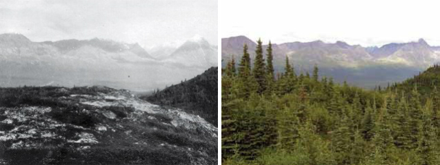
Left photograph by Stephen R. Capps. Right photograph by M. Torre Jorgenson.
Scenario narratives are stories that help participants to visualize a range of divergent, yet plausible, relevant and challenging futures. This example is a hypothetical letter from future constituents to their senator, describing the issues they could be dealing with about 20 years from now and asking the senator for help.
Dear Senator Goforth,
We the undersigned appreciate your many years of wise public service and support for Alaska’s coastal communities. We are writing today to ask your help again in dealing with a crisis for which government agencies seem unable or unwilling to help our communities. You are well aware of the importance of community, place, and subsistence to rural Alaskans.
While most people in our communities still live a subsistence lifestyle, it has become harder to subsist, and harder to maintain a viable community. After more than a decade of diminishing stream flows and sharply declining salmon returns, many local fishermen have been forced to sell their salmon permits, their livelihood, and their family legacy to out-of-state businesses. After our fish processing plant closed, more people left to seek wage work elsewhere. We were devastated when school enrollments dropped below the minimums. Because schools have closed, there will soon be few younger people and families left in the community. With the prohibitively higher costs of fuel and electricity, we are thankful that some residents still have good paying jobs in government and community services. But the number of such positions has also declined with falling tax revenues. A few residents found jobs with new construction, wind farms, and mining operations on nearby state and corporation lands, but most good jobs seem to be filled by Outsiders.
Federal and state agencies have compounded the challenges faced by our communities. For example, with the loss of salmon, we have increasingly looked to hunters to provide for our aging residents. The decades-long drought, coupled with a history of water resources mismanagement, deforestation by wildland fires and mining impacts, and steadily increasing federal predator protection, has made it increasingly necessary for hunters to travel long distances to find harvestable wildlife. Agency regulators don’t appreciate that the changed landscape and unrealistic hunting seasons make access by boat, foot, and snow machine unreliable. Now, those same agencies are working against our hunters, by denying use of ORVs for access to game on government lands. Senator, we need the agencies to work with our public, not against us, and we desperately need more good jobs in our rural communities before our young families all move away to hub communities and urban areas.
Today, we ask for your sponsorship of the “Salmon for our Children” bill, a program to fund construc-tion and operation of an expanded network of government-funded community salmon hatcheries. We also ask for your support of a local-hire mandate, provisions for securing any necessary water rights from adjacent federal lands, and reasonable community access to federal lands by ORV in this bill.
Respectfully,
The Members of the Peninsula Mayors Council

References
Cole, D.N., and L. Yung. 2010. Beyond Naturalness, Rethinking Park and Wilderness Stewardship in an Era of Rapid Change. Island Press.
Fresco, N. 2011. University of Alaska, Scenario Network for Alaska Planning with Climate Briefs, Climate Drivers Table, Climate Projections, and other documents. http://bit.ly/jYBKxs
Schwartz, P. 1996. The Art of the Long View. Doubleday.
Schwartz, P., and D. Randall. 2003. An abrupt climate change scenario and its implications for United States National Security. Global Business Network. http://www.gbn.com/articles/pdfs/Abrupt%20Climate%
20Change%20February%202004.pdf
Jezierski, C., A. Schramm, and R. Loehman. 2010. Understanding the Science of Climate Change – Talking Points Impacts to Alaska Maritime and Transitional Zones. https://www.nps.gov/climatechange/docs/MaritimeTransitionalTalkingPoints.pdf
Part of a series of articles titled Alaska Park Science - Volume 10 Issue 2: Connections to Natural and Cultural Resource Studies in Alaska’s National Parks.
Last updated: August 9, 2016
