Article

World War II Aleut Relocation Camps in Southeast Alaska - Chapter 3: Funter Bay Mine, pt. 1

Color photo of buildings along a shore with forest backdrop
Figure 57. Historic buildings and building ruins of the Admiralty Alaska Gold Mine are visible along the shore of Funter Bay. From left to right are: the wash house ruin, the two-story bunkhouse, the shop, the roof of the mill, the Sam Pekovich residence, and a modern prefabrication metal building.

Villagers from St. George were housed at the shoreside camp of an old gold mine on Funter Bay (Figure 57). The Admiralty Alaska Gold Mine is a collection of old buildings including a mill, a road and tramway inland, two adits and other workings, and the seasonal homes of Sam Pekovich and Andrew Pekovich. The mill and mining camp are located about one mile from the cannery, on the southeast shore of Funter Bay (Figure 9). The mine is patented land owned by Sam and Andrew Pekovich and the Admiralty Alaska Gold Mining Company, and includes old mineral claims going back to the late 1890s. The land near the coast is gently rolling and steepens inland to become Robert Barron Peak. A thick forest of hemlock and spruce, with some cedar and fir, blankets the landscape (Guard 1958:6).

Early Years

The claims were originally staked by Richard G. Willoughby, a prospector and opportunist who worked his way north along the Pacific Coast in the mid-19th century, arriving in Wrangell by 1875 (DeArmond 1957). Willoughby was a contemporary of Joe Juneau and Richard Harris – the historical discoverers of gold at Juneau in 1880. He subsequently kept a cabin in Juneau on the street eventually named for him, becoming “one of the best known pioneer miners in Alaska”(New York Times 1902). Between July of 1888 and January of 1889 Willoughby and his partner A. Ware staked ten mineral claims on the southeast shore of Funter Bay (Chipperfield 1935). The territorial governor reported in 1891 that the Funter Bay mine “has continued its usual activity” (Knapp1891:30), but the details are unknown. Six years later Willoughby (without his partner) amended the claims, according to Chipperfield (1935), and in 1902 he died while in Seattle (New York Times 1902).
Black and white photo of a pier with buildings along the shore and mountains behind
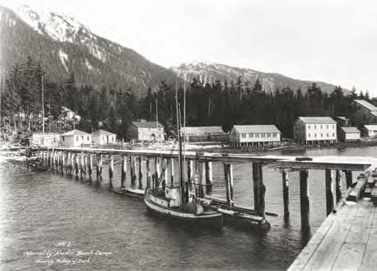
Figure 58. Looking south from the dock around the early 1920s, the mill building of the Admiralty Alaska Gold Mine stands at far right. The two-story bunkhouse right of center was still in use in 2008, as was the tool shed immediately to its right.

Alaska State Library Winter and Pond collection PCA 87-0394

The Territorial Commissioner of Mines (Maloney 1915:12) reported in 1915 that “the old Funter Bay mine on Admiralty Island has been reopened and “was operated on a profitable basis during the year.” On December 20th or 29th, 1919, Henry Roden, W.S. Pekovich,and other citizens of the Territory of Alaska incorporated the Admiralty Alaska Gold Mining Company with control over Willoughby’s claims, according to documents in the possession of mine investor, officer, and caretaker Andrew Pekovich. By then several owners had come and gone, according to Pekovich – a son of Serbian immigrant W.S. Pekovich. The Admiralty Alaska Gold Mining Company was formed to develop the Funter Bay claims, and the sale of shares funded construction of a waterfront mill and support buildings (Figure 58), plus a rail line to workings including two adits inland at the base of Robert Barron Peak. In July of 1923 the Admiralty Alaska Gold Mining Company amended and recorded Willoughby’s ten claims (Chipperfield 1935).

U.S. Geological Survey geologist A.F. Buddington (1926:46) described the Funter Bay deposits as mostly gold-quartz veins accompanying the Mertie Lode – a mineralized sulphide at about the 2000’ elevation and 6000’ from the mill. By 1929 gold-quartz veins had been mined from four claims: the Tellurium, Uncle Sam, King Bee, and the Heckler Blanket, and three concentrate shipments were sent to the smelter at Tacoma in 1926 and 1927 (Eakin 1929:6-7). W.S. Pekovich left the Board of Officers to serve as General Manager during those years, according to Andrew Pekovich.

The 1930s were generally good years for mine operators, at first because of the Depression’s cheap labor, then inadvertently in 1934 because President Franklin D. Roosevelt made private ownership of gold illegal, forced citizens to sell to the government at $20.67 per ounce, and subsequently revalued it at $35 per ounce (Saleeby 2000:33-34). But the Admiralty Alaska Gold Mine had little if any production during those years. In 1935 the company applied for a patent to the ten Funter Bay claims, prompting the USFS District Ranger’s report (Chipperfield 1935) and leading to legal ownership of the land. Chipperfield described the buildings and workings, and their condition, and opined that the claims had been idle for the three prior years.

The lack of activity noted by the USFS District Ranger in 1935 reflected the Funter Bay mine’s corporate officers’ attention being focused instead on mining to the south at Hawk Inlet. In addition to being an officer for the Funter Bay mine, Henry Roden was also President of the Alaska Empire Gold Mining Company according to a December 12, 1932, letter submitted with a Hawk Inlet mine report by Juneau surveyor Frank A. Metcalf. That company was associated with the Hawk Inlet Gold Mining Company (Alaska State Library 2002). W.S. Pekovich was also General Manager for the Alaska Empire operation and lived at Hawk Inlet with his family for much of the time between about 1932 to 1950, reports Andrew Pekovich, leaving his father’s cousin Rado Pekovich as caretaker at the Funter Bay mine. Connections between the mining companies were strong, with suggestions in the archival record that claims and equipment were shared or exchanged (Stewart 1933:13; Townsend 1941). Together they controlled 200 claims stretching from Funter Bay to Hawk Inlet (Stewart 1933:13).

Strategic material surveys conducted in support of World War II prompted the U.S. Geological Survey to assemble existing mining reports for government review. Geologists A.F. Buddington’s notes and reports of visits to Funter Bay in 1936, 1937, and 1938 were used by geologist John Reed (along with his own visit) to evaluate Funter Bay’s potential wartime mineral contribution in 1942. Of interest was the nickel-copper component of the Mertie Lode higher up the slope of Robert Barron Peak, but Reed’s (1942) report judged the ore grades insufficient to warrant mining.

Line drawn map with points along a road labeled A-V labeled "Pribilof Evacuation Camp"
Figure 59. A map of the Admiralty Alaska Gold Mine’s mill and camp buildings made in August of 1942 (with bold letters added) shows a six-room building (U) built for St. George evacuees upslope from the original alignment of buildings. Building F is listed in the legend but was not originally plotted – it burned down soon after St. George villagers arrived. Building G was listed but not plotted – it was soon constructed at the tideline across from Building E. The dotted line is a domestic pipe.
Black and white photo of a wood framed building.
Figure 60. A one-story frame building north of the mill (Building N on Figure 59) is said by Sam Pekovich to have been the assay office, though the 1942 map identifies it as living quarters and a smaller building further south as the assay office. Note at lower left a stack of rollers for vanners.

Alaska State Library Butler/Dale collection PCA306-neg898.187 (Aleuts)

A map made in August of 1942 shows most of the original shoreline buildings described by Chipperfield seven years earlier (Figure 59). All the buildings were of frame construction. Dominating the shoreline was the tall mill building, measuring 40’ x 60’, with its steep, conspicuous roof. A tram track from the upland workings dumped ore from a cart into the top of the mill to begin the processing system. In a typical mill of the period, the ore would fall onto a “grizzly” or grate and be sorted for feeding either directly into a battery of stamps or through a crusher first and then the stamps; from there the finely crushed ore would progress down through the mill across amalgamating plates and on to concentration tables (Sagstetter 1998:56). In 1935 Chipperfield noted that the ten stamps once operating at the mill had been removed. A photograph of a building said to be the assay office incidentally shows a pile of vanner rollers (Figure 60), providing more detail about the ore concentrations and sorting systems. Other major industrial features on the shoreline were a shop and an assay office, plus one and then later two wharfs (Figures 58-59).

Many of the shore buildings mapped in 1942 were for housing. Two buildings on the north end of the alignment were “permanently occupied” – one by Rado L. Pekovich, who was identified as the watchman, and the other by Mrs. S. Pekovich – the first wife of W.S. Pekovich. A two-story 24’ x 50’ bunkhouse on pilings over the intertidal zone, with space for 20 people, was described as unfinished in 1935 by Chipperfield. An older bunkhouse (Building E), identified as 2-story from photographs (Figures 58, 61), measured 20’ x 40’. Three buildings are identified as “living quarters,” with three or four rooms each (Figure 59). Other dwellings consist of one “bungalow” and a couple “shacks.” Two buildings (one 20’ x 40’, the other 24’ x 40’) are listed as “mess house,”each with a secondary function – one had storage rooms, the other was used as a warehouse and office with a dormitory in the loft. The 1942 map doesn’t plot the mess house with storage (Figure 61) because it burned down within a couple months of the Aleut arrival.
Composite of four black and white images. Top: two photos of wooden buildings with boardwalks. Bottom: interior shot and outhouse photo.
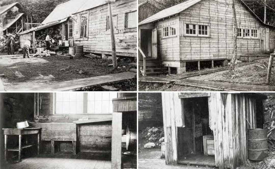
Figures 61-64. Top: Old mess house. Building T, later home of Sam Pekovich. Bottom: Large pots and a sloping dishdrainer suggest this may have been the interior of the mine’s mess hall. In contrast to the cannery, the Funter Bay mine had at least one outhouse on land.

Fig. 61: University of Alaska Fairbanks Fredericka Martin collection 91.223.3417
Fig. 62-64: Aleutian Pribilof Islands Association (copy print, source unknown)

Utilities for the mine were simple. Water was piped to a large laundry/toilet/shower building south of the mill –Building T (Figure 62). The source was either a small impoundment box on a creek to the southeast or via the existing large 3’-diameter penstock laid in a ¾ mile-long ditch to serve the milling process. A WW II period photograph of a kitchen interior shows a wood washing basin served by two independent sets of 1” pipe, indicating a hot-water heater (Figure 63). An outhouse serving the southernmost dwelling (Building R – the home of “Smiley” Jukich, the maternal grandmother of Sam and Andrew Pekovich) was perched over a small creek about 30’ from the high tide line. Outhouses serving the remainder of the pre-war mining camp are not identified on the map and may have been attached to one or both wharfs extending into the bay. Two small buildings near the tide line identified as women’s toilet and men’s toilet (Figure 59) were almost certainly constructed for the mine’s new wartime occupants. A wartime photograph shows a third outhouse on land upslope (east) of a shoreline boardwalk (Figure 64).

The Admiralty Alaska Gold Mine had more than one power source, though likely not all were in operation at once. Installed in the mill were two large 100 horsepower Seymour-MacIntosh diesels, accounting for one system. According to Sam Pekovich, another generator was housed in a shed just east across the boardwalk from the bunkhouse (Building L; though the small building isn’t plotted, it shows on WW II photographs). Serving the mine adits and aerial tram was a large onsite Pelton wheel. Archival photographs show poles and overhead electrical lines extending north at least to Building B, and – since the northernmost cabin A was identified as “permanently occupied by Mrs. S. Pekovich” – the line probably extended to her home also.

World War II and the Camp Experience

By June of 1942 the Admiralty Alaska Gold Mine had been out of production for at least 15 years, and no longer was there the need for a large crew of workers or the shoreside facilities to serve them. Rado Pekovich was the mine's onsite caretaker and at least one other related individual lived there, while the W.S. Pekovich family lived (until about 1950) at nearby Hawk Inlet. Negotiations between the federal government and representatives of the mine are evidenced in the archives only by a July 15, 1942, letter sent from USFWS General Superintendent Edward C. Johnston in Seattle to Alaska Indian Service agent Claude M. Hirst in Juneau, implying that initially the President of the mining company (probably still at that time Henry Roden, a well-connected territorial politician) wanted $250 per month to house Aleut evacuees. Ultimately the mine was leased for one dollar per year, according to Pekovich family members.

Black and white photo of four men gathered on a rough wood porch.
Figure 65. Mine watchman Rado Pekovich (right) talks with USFWS agents Lee McMillan (center), Carl Hoverson (left of center), and Roy Hurd (far left). At far right is the mess house (Building K). At far left is Building B with Buildings C, D, and E behind and center.

University of Alaska Fairbanks Fredericka Martin collection 91.223.277

St. George villagers had more or less the same evacuation experience as the St. Paul villagers, arriving at Funter Bay on the USAT Delarof together and disembarking at the cannery on June 24. The following day the St. George villagers were moved across the bay to the mine. Fewer archival photographs are available for the mine compared to the cannery, and only two wartime images show activity – men chopping wood for the mess house (Figure 61), and a meeting between Rado Pekovich and USFWS officials Lee McMillan, Carl Hoverson, and Roy Hurd (Figure 65).

The mining camp facilities adequate for the Pekovich family’s activities were not adequate to comfortably serve the entire village of St. George, and an onsite report prepared by USFWS officials three days before the arrival of the Delarof and its human cargo described those inadequacies. Old cords and bare wires created electrical hazards, the assay office and mill contained poisonous chemicals, the existing sewage system consisted of only two outhouses on pilings over the beach, and drinking water was not piped to any of the buildings. The mining camp’s buildings were generally smaller than those of the cannery, but were in better shape.

Black and white photo of buildings along a shore with Cyrillic writing below.
Figure 66. A photograph of the Funter Bay mining camp annotated in Cyrillic describes the buildings. 1. Chicken coop, 2. Hospital, 3 & 5. Barracks, 4. Kitchen, canteen, food storage warehouse and temporary church, 6. Gold mine mill.

Aleutian Pribilof Islands Association Fr. Michael Lestenkof collection

Villagers immediately set to work to make the place more habitable, erecting tents, repairing buildings, improving the plumbing, and addressing the most obvious safety issues. Many cords of wood had to be cut – with saw and axe – to heat the drafty buildings. Fishing teams, hunting parties and clamming expeditions were undoubtedly organized to feed the villagers as they were for the St. Paul contingent across the bay. An annotated photograph of the camp (Figure 66) indicates that the village priest, Father Feodosiy, lived three winters in Building B (Figures 59, 65). A room at the end of the mess house (Building K) was converted into a small chapel using the icons and vestments brought from the church at St. George (Figures 67-68).

Composite of two black and white photos. Left: mostly empty interior. Right: highly decorated alter
Figures 67-68. The one-story mess house had a room set aside as a chapel, here seen through the doorway with across and the date “1944” painted above. St. George villagers brought with them the icons and vestments from their Russian Orthodox Church and reconstructed the village altar.

Left: Aleutian Pribilof Islands Association (copy print, source unknown). Right: Aleutian Pribilof Islands Association Fr. Michael Lestenkof collection

The cannery continued to be the social center, having the post office, the store, and the floats and wharf for delivery of freight and passenger service to Juneau and elsewhere. Of the two Pribilof villages St. George typically received less federal attention and resources compared to St. Paul because the latter had much larger seal rookeries and a harbor – and therefore a larger Native population maintained by USFWS. So it was not surprising that the St. Paul camp, with three times the population as St. George, was the hub of activity. Small resident boats and skiffs plied Funter Bay regularly but the Aleut villagers arrived with only two baidars and those belonged to USFWS, so local transportation was likely limited at first. Father Michael Lestenkof had evacuated his outboard motor from St. Paul, and Father Feodosiy procured a skiff, according to St. George elders Terenty Merculief, Sr., Andronik Kashevarof, Sr., and Victor Malavansky, who alluded in a 1998 interview to a youthful wartime event in which some or all of the three “borrowed” the priest’s boat and almost swamped it in the bay.

Health and sanitation were chronic problems at both Funter Bay camps during the internment, and several government officials from various agencies wrote frank reports describing the dismal circumstances of the displaced Aleuts. One of the more sensational accounts was that of Alaska Attorney General Henry Roden as delivered in an often-cited letter to Governor Ernest Gruening after Roden “had occasion to visit Funter Bay in mid-September 1943” (Kirtland and Coffin 1981:43). Overlooked is the fact that Roden had been a longtime officer (President and Treasurer) in the Admiralty Alaska Gold Mining Company (Alaska State Library 2002), and he may have been the person who had attempted negotiating the $250 lease for the property. Roden had a long political career that included seats in the 1st Territorial Senate (1913-1914), the 13th (1937-1938) and 15th (1941-42), as well as service as Attorney General in 1928-1929 for Governor James Wickersham and later in 1943. As both a well-connected territorial official and a longtime Funter Bay mine investor he may have had an influential role in the decision to house Aleuts at Funter Bay.

Wartime Construction

Tents were used to house the overflow of villagers at the Funter Bay mine until more buildings could be erected. One of the first construction tasks was to complete the unfinished bunkhouse. In early August the USFWS vessel Penguin delivered materials with which to build a long narrow one-story bunkhouse (Kohlhoff 1995:94), labeled as Building U on the 1942 map (Figures 59, 69). It was constructed on a raised bench overlooking the camp and was reached by a flight of stairs from the boardwalk (Figure 72). Materials were also delivered for a wash house (Building G) built on pilings at the high tide mark across from Bunkhouse E (Figure 70). The building had four doors facing east towards the boardwalk. Based on his post-war familiarity with the building, Sam Pekovich described the south room as containing a wash room and a one-hole privy against the wall over the beach. The next room north contained three toilets. The room after that contained three showers. The north room contained a woodstove and boiler, a 300-gallon wood water tank, and a 4-kw generator that likely postdated the war period. In 1944 ten surplus Army Quonset huts were brought to Funter Bay, of which two were erected at the mining camp on the water side of the boardwalk across from the assay office or Building N (Zacharof 2002).

Some original mining camp buildings were destroyed during the internment. Within a few short months a power house and the old mess house (Building F) burned to the ground, according to Sam Pekovich.

Post-War Development

After the villagers went back to St. George, the Pekovich family continued their involvement in the Funter Bay mine property through their stock holdings in the Admiralty Alaska Gold Mining Company (which owns 130 acres), their status as officers and caretakers for the company, and their eventual ownership of about 35 adjacent acres. The Territorial Commissioner of Mines continued to list the mine as active into the 1950s, when 30 people were said to have been employed doing maintenance (Holdsworth 1955:75). As late as 1958 “the main camp buildings and general facilities are adequate to take care of a large crew,” and except for “a small Jeep..., a power wagon, Willys pickup, or other front-wheel-drive truck, pipes, rails, ties, vent pipes, fan... for driving a 1,200 foot tunnel, [and] a small jumbo [drill],...the equipment and tools on the property are nearly adequate to proceed with the suggested exploration program” (Guard 1958:3-4).

The mine’s shoreline was mapped as part of Alaska Tidelands Survey 712 in 1970, at which time most of the original buildings were still standing (Figure 72). Little work was done on the claims in subsequent decades, but the continuing stream of lead, zinc, silver, and gold from Hecla Mining Company’s Greens Creek mine only 20 miles away has sustained the hope that the Funter Bay deposits will someday be brought into production. For two summers in the mid-1980s crews mapping the geology of the Mansfield Peninsula for Noranda Exploration leased the two-story bunkhouse, according to Sam Pekovich.

The camp has seen some changes in its building inventory in recent decades. Building T at the south end of the camp was remodeled and enlarged by Sam Pekovich as a second residence to his home in Juneau. The dwelling (Building R) at the far south end of the complex (Figure 71) was removed and a modern prefabricated utility building (Figure 73) was installed nearby in about 2005. At least one other original mine building was demolished for the material by local residents.

Black and white map showing location of cabins, bunkhouses, residences, warehouses, shops, etc along a road
Figure 72. In 1970 the Admiralty Alaska Gold Mine’s shore features were mapped as part of Alaska Tidelands Survey 712 (from which this illustration was prepared). Labels are those of the 1970 survey; letters correspond to those of the 1942 map (Figure 59).

Part of a series of articles titled World War II Aleut Relocation Camps in Southeast Alaska.

Aleutian Islands World War II National Historic Area

Last updated: February 14, 2021