|
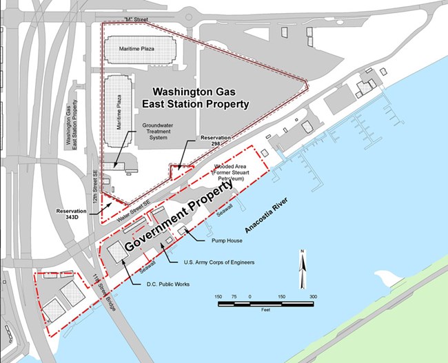
Washington Gas – East Station Site is located in southeast Washington, D.C. along the western bank of the Anacostia River, south of M Street and east of 11th Street. The site includes areas impacted by the residuals of gas manufacturing. 
NPS Site HistoryThe Washington Gas - East Station Site (the Site) includes an area located adjacent to the former gas-manufacturing plant operated by the Washington Gas Light Company (Washington Gas). The Site currently includes soil, sediment, and groundwater contaminated with hazardous substances associated with previous plant operations. The National Park Service (NPS), with support from the District of Columbia Department of Energy & Environment (DOEE), is overseeing environmental investigations and cleanup activities at the Site under the Comprehensive Environmental Response, Compensation, and Liability Act (CERCLA). NPS and DOEE are overseeing CERCLA investigations performed by Washington Gas as part of a 2012 Consent Decree. Washington Gas manufactured gas at its former plant continuously from 1888 to 1948, and intermittently from 1949 until the mid-1980s. Coal and oil were the primary materials used in the gas-manufacturing process. By-products of the manufacturing operations were occasionally disposed of and used as ground fill on the adjacent property, which was owned by the United States and managed by NPS. This land, mainly between Water Street and the Anacostia River, is called the “Government Property” in Site documents and was recently transferred to the District of Columbia (the District). The fill from the manufactured gas plant included residual products from the cleaning of coke filter beds, tar that was mixed with solid waste, and wood chips contaminated with absorbed tar and cyanides. The plant was demolished in 1986, and the aboveground oil storage tanks on the Washington Gas property were removed in 1997. Plant operations and disposal of materials generated during the gas-manufacturing process caused contamination of soil, groundwater, and Anacostia River sediments. NPS and DOEE are currently overseeing remedial investigations (RIs) intended to determine the nature and extent of this contamination. The initial CERCLA investigation and cleanup activities focused on soil and groundwater at the parcel of land bordered by Water Street SE to the northwest, the wooded area near the Eastern Power Boat Club to the east, the Anacostia River to the southeast, and the southbound lanes of the 11th Street bridge to the west (labeled “Government Property” on the Site Map). The environmental investigations currently being conducted are focused on groundwater and Anacostia River sediments. To allow initial cleanup activities to occur while other investigations continued, the Site was divided into two operable units (OUs). OU1 is surface and subsurface soils (also known as the “landside portion”) located on the “Government Property” area described above; and OU2 includes groundwater, surface water, and sediments of the Anacostia River (also known as the “in-river portion”). OU1 has a known physical boundary (described in the previous paragraph). The boundaries of OU2 are currently being determined through the ongoing RI. Washington Gas–East Station Site Environmental InvestigationsBeginning in 1983, several environmental investigations were conducted at and near the Site to evaluate the nature and extent of contamination, evaluate risks to human health and the environment, and analyze cleanup alternatives. Those investigations showed that the Site was contaminated with industrial waste from the former manufactured gas plant. Additionally, water beneath the surface at the Site, both shallow and deep, has also been determined to be contaminated with hazardous substances associated with those historical operations. Hazardous substances from the former plant operations have also been detected in the sediments of the Anacostia River. Based on the results of these investigations, and in accordance with CERCLA, NPS selected a remedial action for OU1 in a Record of Decision (ROD) issued on September 14, 2006. The selected remedial action included:
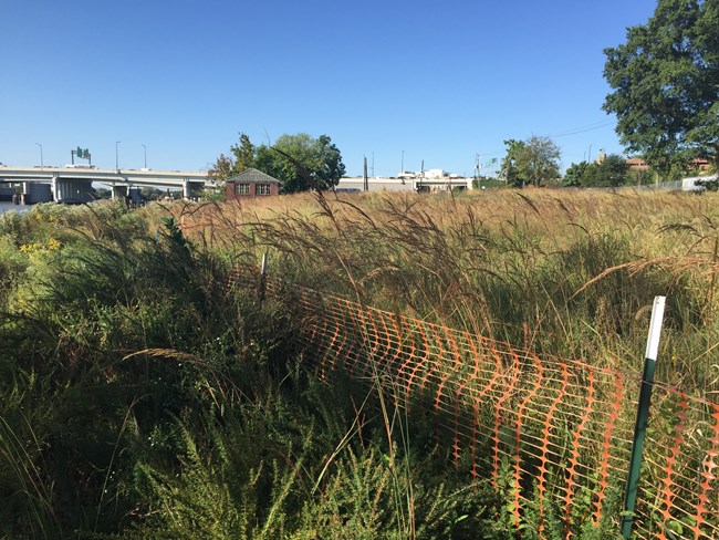
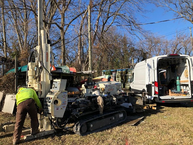
The ROD for OU1 recommended (1) that an existing pump-and-treat system on the site of the former manufactured gas plant remain in operation and its effectiveness be further evaluated, as well as (2) further investigation of OU2. In 2015, Washington Gas, with oversight from NPS and DOEE, performed soil removal at the Site and replaced excavated contaminated soils with clean fill and topsoil. NPS and DOEE assisted with selecting native meadow plants for OU1 that would increase biodiversity. Washington Gas currently operates a groundwater treatment system on the site of the former manufactured gas plant. This system is intended to capture contaminants that may otherwise migrate off-site in groundwater. On-going OU2 investigations will provide data to help determine the current pump-and-treat system’s effectiveness at preventing off-site migration of groundwater contaminants. Washington Gas began its investigation of OU2 in 2015. The objective of the investigation is to check the effectiveness of the groundwater treatment system and to determine the nature and extent of contamination in groundwater, surface water, and sediments of the Anacostia River resulting from migration of contaminants from the former manufactured gas facility. The OU2 investigations that began in 2015 have been completed in phases. After collection of data and at each important decision point during the ongoing OU2 RI, Washington Gas summarized the data collected in a Technical Memorandum, which also proposed the next investigation steps. Washington Gas submitted each Technical Memoranda to NPS and DOEE for approval prior to beginning the next investigation step. The OU2 investigation encompasses the upland portion of the Site (also identified as the government property, or “landside portion”) and the nearby reach of the Anacostia River (identified as the “in-river portion”). All OU2 investigation results will ultimately be summarized and evaluated in the OU2 RI report. The sections below describe the OU2 RI activities which began in 2015 and continue today and also the achievement of the OU1 vegetation performance standards. October 2015 through March 2016Landside Investigative Activities:Contractors for Washington Gas drilled borings as deep as 80 feet below ground surface at 28 locations. Soil cores collected from these borings were inspected for soil type and evidence of contamination, and soil samples collected from the borings were analyzed for manufactured gas-related chemicals. Following completion of field work in December 2015, Washington Gas prepared Technical Memorandum 1, which included illustrations of cross-sections showing the geological layers along and away from the Anacostia River. The cross-sections show the geology, which may identify possible pathways for contaminants to travel through groundwater to the river. As part of Technical Memorandum 1, Washington Gas proposed locations and depths where groundwater samples should be collected to confirm whether these pathways (for example, sandy layers) are present. During the subsequent field work, Washington Gas also collected samples of site-related contamination (coal tar) that gathers in their recovery wells; the analytical results can be used to compare chemical “fingerprints” in other samples. April 2016 through May 2016Landside Investigative Activities:Contractors for Washington Gas used grab groundwater sampling probes at 24 locations to collect a total of 51 groundwater samples from various depths. The information from these groundwater samples indicated approximately how much water was flowing through the soil at each depth, and whether manufactured gas-related contaminants were present. The cross-sections prepared as part of Technical Memorandum 1 were updated with this information. Work performed in April and May 2016 was documented in Technical Memorandum 2, which also presented proposed locations for new groundwater monitoring wells. The purpose of the monitoring wells is to allow the collection of groundwater samples from the same locations at different times to provide information about how contaminants move in groundwater and how the contamination concentrations change over time. June 2016 through March 2017Landside Investigative Activities:Washington Gas evaluated the data from their landside investigations—including geology, presence of contamination, groundwater movement, and groundwater sampling results—to identify areas where contaminants may be moving from the land towards or into the Anacostia River. Technical Memorandum 3 summarized this information and proposed the collection of sediment, surface water, and groundwater samples from beneath the river in areas most likely to be affected. Because the Anacostia River is tidal and contaminants can move both upriver and downriver, Washington Gas also identified locations in the Anacostia River that could serve as reference locations (i.e., background locations) to document the river’s conditions in areas not expected to be influenced by contamination related to the Site. April 2017 through August 2019In-River Investigative Activities:Washington Gas collected samples from the top 6 inches of sediment in the Anacostia River. Washington Gas used analytical data from these samples to propose 15 locations where additional samples would be collected to evaluate (1) the aquatic biota living in the shallow sediment and (2) the impact of the detected contamination on organisms living in the shallow sediments. The proposed sampling locations and rationale are described in Technical Memorandum 4. In August 2017, Washington Gas expanded the in-river sampling area and collected additional sediment, surface water, and groundwater (beneath the Anacostia River) samples. Sediment from sampling cores were collected from a total of 72 locations from an area between the I-695 bridges downriver to the west, and upstream to the eastern edge of the Eastern Power Boat Club property to the east. Washington Gas communicated the results of the in-river sampling to NPS and DOEE results of the in-river sampling in early 2018 and agreed to include the results in the draft RI report. Landside Investigative Activities:Based on the results of the landside investigation completed in 2016 and 2017, the landside investigation area was expanded to the east to include the Eastern Power Boat Club. Shallow soil and groundwater at the Eastern Power Boat Club is being investigated separately under DOEE oversight. Contractors for Washington Gas drilled additional soil borings and installed groundwater monitoring wells to check for manufactured gas-related chemicals. The results of the investigation are presented in Technical Memorandum 5. Based on their monitoring, Washington Gas found that the pump-and-treat system does not capture all groundwater at the government property and the Eastern Power Boat Club property, and some flows into the Anacostia River. About three-quarters of the groundwater that crosses the seawall boundary is in the fill unit, and almost a quarter of the water that flows across this boundary is in the sand and gravel unit, which is about 40 feet below ground surface. The groundwater that is not captured carries chemicals from the buried manufactured gas waste from the land to the Anacostia River. Using the concentrations of chemicals detected in groundwater samples from monitoring wells close to the seawall, Washington Gas estimated the weight of contaminants that discharge to the Anacostia River. In 2017, these included annual discharges of benzene (39 pounds per year), cyanide (12 pounds per year), and polycyclic aromatic hydrocarbons (PAHs) (1.6 pounds per year). The timing of the discharges is related to the tides in the Anacostia River: more groundwater and contaminants flow to the river at low tide than at high tide. The discharges are visible sometimes at low tide when rainbow-colored, oily sheens appear on the surface of the river at the seawall. Washington Gas is responsible for maintaining the floating white booms beside the seawall that are intended to capture these sheens. 
NPS October 2019 through OngoingLandside Remedial Action Activities (OU1):In 2020, NPS documented that Washington Gas achieved the required vegetation performance standards as required by the Consent Decree. In October 2021, the District recorded an Environmental Covenant that restricts future excavation at the Government Property that could result in releases of or exposure to contaminants that remain in the ground. In 2023, NPS documented the achievement of all of the remedial action performance standards for OU1. 
NPS Landside and In-River Investigative Activities (OU2):Washington Gas collected additional data to further evaluate the high benzene concentrations found in groundwater in the sand and gravel unit underlying the Site. The additional investigations included landside drilling at more than 45 borings to screen for indications of benzene and soil types using a membrane-interface probe and hydraulic profiling tool and collection and analysis of groundwater samples and soil cores. Washington Gas also collected groundwater samples from beneath the Anacostia River. The results of these additional investigations will be provided in the OU2 RI Report, which is currently being prepared. Community InvolvementCommunity involvement is an important part of the CERCLA process and the public will have the opportunity to review and comment on the proposed cleanup action for OU2. Washington Gas - East Station Site DocumentsThe Site Administrative Record (AR) consists of the documents that form the basis for the selection of the CERCLA cleanup action. NPS maintains two administrative records for the Washington Gas Site, one for OU1 and a separate AR for OU2. The OU1 administrative record index lists all documents that served as the basis for determining the response action for OU1. The OU2 administrative record index includes documents related to OU2 activities through October 2015. NPS has prepared a list of documents that are not yet included in the OU2 AR, including the technical memorandums noted in the sections above. Contact InformationNational Capital Parks — East Superintendent's Office |
Last updated: May 19, 2025
