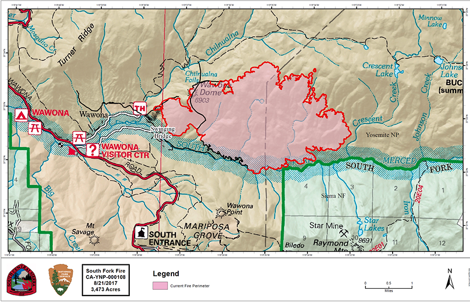
South Fork Fire
Start date: 8/13/17 2:30 pm
Size: 3,473 acres
Cause: Unknown
Fuels: Mixed conifer, oak and brush
Crews made significant progress yesterday building and strengthening line on the west side of the fire above Wawona. Contingency lines were also established to the northwest leading to Turner Ridge. Firefighters now have access to the South Fork and have been inserted to extinguish spot fires that have been occurring the past few days. Today crews will continue burning operations above Wawona from the fireline to the South Fork of the Merced. Mandatory evacuations will remain in place in Wawona for the area east of Highway 41 on Forest Dr. and Chilnualna Falls Rd. until further notice.
The fire remains active on the west and south edges. Crews continue to spike in an effort to utilize as much daylight as possible. A combination of firing operations, air support, and direct line construction will continue. Aircraft will assist ground crews when conditions allow generally beginning mid-day.
Strategic objectives remain the same: continue suppression efforts by utilizing air and ground resources to hold the western and southern flanks while monitoring the northern and eastern edges. Minimal Impact Suppression Tactics are being used in the Yosemite Wilderness to manage the area of the fire, using natural barriers such as rocks or streams, trails, and other minimal disturbance methods to contain the fire.
Thunderstorm activity is expected to cause erratic winds over the fire area through mid-week. Gusty winds associated with thunderstorms could cause problematic fire activity near the fire if they materialize.
There are currently 758 personnel assigned to the fire: 22 hand crews, 7 helicopters, 20 engines.

Empire Fire
Location: N 37° 38' 40" x W 119° 37' 6" at approximately 7,300 feet elevation
Discovery Date: July 31st, 2017
Size: 1,750 acres
Cause: Lightning
The Empire Fire is being managed for both resource and protection objectives. It is approximately 1 mile south of the Bridalveil Creek Campground east of Alder Creek drainage and west of Bridalveil Creek drainage, burning in Red fir. Fire behavior has been actively flanking and backing with some single and group tree torching. The fire is burning in heavy pockets of dead and down timber, reducing fuels buildup which increases forest resiliency. Projected fire growth is expected in the northeast and southeast flanks.
The affected area is in a fire-adapted wilderness. Allowing fires to burn naturally can result in healthier, more diverse ecosystems. Reducing fuels buildup minimizes the potential for future severe fires. Although the current fire may have transient, moderate smoke impacts, more severe fires can cause unhealthy levels of smoke for extended periods, over a much wider area.
Trails are closed from Bridalveil Creek Campground at the second junction with the Ostrander trail and from Westfall Meadow to the Deer Camp junction, along Alder Creek. Bridalveil Creek Campground is closed for fire resource use.
The fire will be visible from the high country and may be seen from multiple viewpoints in the immediate area off Glacier Point Road including Sentinel and Washburn Points.
Fire Managers are working with the local Air Quality Districts and will be monitoring smoke impacts to the park and local communities. Community members who are sensitive to smoke may want to close their windows and doors and monitor the air quality links below.
Additional information
- Rapid Notify is a community alert system for rapid event notifications. Register by visitinghttp://www.rapidnotify.com/
customer/Yosemite.html or https://alert.rapidnotify.com/ . - Nixle is a public-safety notification system. Sign up for emergency alerts by texting 95389 to 888-777 or visit their website at www.nixle.com
- Fire Information: e-mail us
- Yosemite National Park Fire Information website: http://www.nps.gov/yose/blogs/
fireinfo.htm - Facebook, search: Yosemite Fire and Aviation: https://www.facebook.com/YosemiteFire
- Twitter, search @YosemiteFire: http://www.twitter.com/
YosemiteFire - Air Quality: https://www.nps.gov/yose/
learn/nature/aqmonitoring.htm or Current PM2.5 conditions
