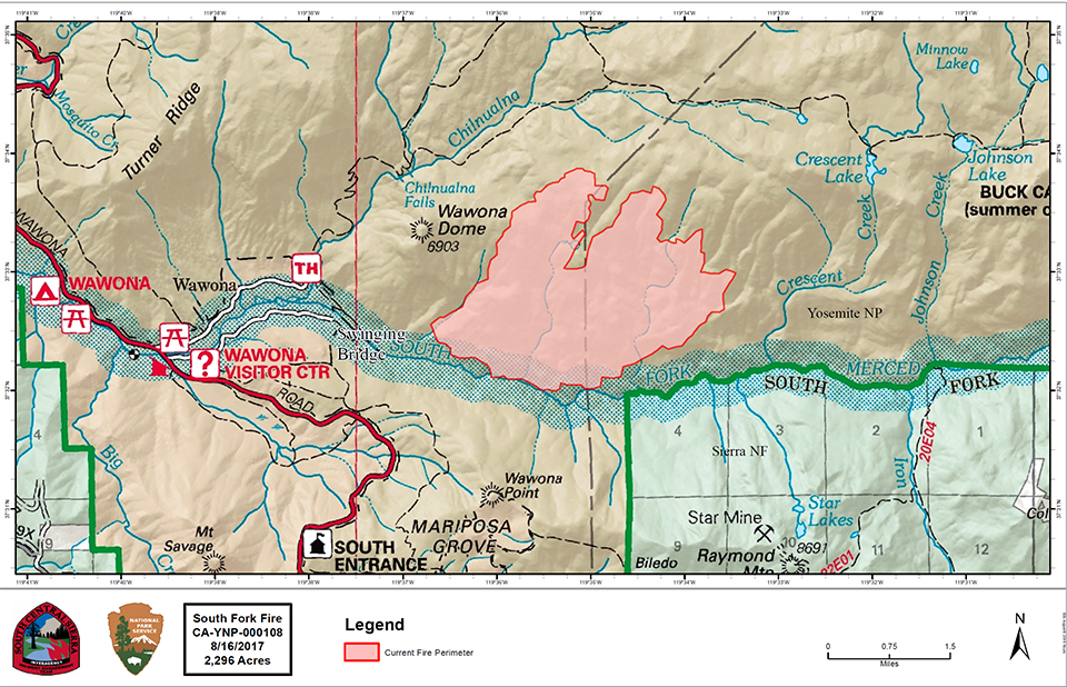
South Fork Fire
Discovered: 8/13/17 2:30 p.m.
Size: 2,296 acres Containment: 5%
Cause: Unknown
Fuels: Ponderosa pine transitioning to White fir
Strategy: Suppression
There will be a community meeting on Wednesday, August 16 at 6 pm at the Wawona Community Center.
The South Fork fire is burning 1 mile east of the community of Wawona upstream of Swinging Bridge in the South Fork of the Merced River drainage. The fireline is holding north of the South Fork and east of Chilnualna Creek. Air resources will continue to assist the firefighting effort in dropping retardant and water on the west and south flanks of the fire.
Smoke is expected to be heavy in the fire area and adjacent communities and is likely to be very dense in Wawona in the evenings and mornings. Community members who are sensitive to smoke may want to close their windows and doors and monitor the air quality links below.
The South Central Sierra Interagency Incident Management Team (Deron Mills IC) assumed command of the fire at 6:00 AM on August 16th.
Current Closures
- Wawona Campground
- Bridalveil Creek Campground
- Chilnualna Falls Trail
- Big Trees Golf Course
- Big Trees Stable - the Wawona mule rides are not operating
- The Badger Pass-Glacier Point shuttle will not operate until further notice as the incident command post is occupying the Yosemite Ski and Snowboard Area facility and parking lot. The Glacier Point Road will remain open to the public, however, it will close periodically between 10am and 5pm each day when parking at Glacier Point fills to capacity (and will reopen when sufficient space is available). Traffic delays should be expected.

Empire Fire
Location: N 37° 38' 40" x W 119° 37' 6" at approximately 7300 feet elevation
Discovery Date: July 31st, 2017
Size: 1400 acres
Cause: Lightning
The Empire Fire is being managed for both resource and protection objectives. It is approximately 1 mile south of the Bridalveil Creek Campground east of Alder Creek drainage and west of Bridalveil Creek drainage, burning in Red fir. Fire behavior has been actively flanking and backing with some single and group tree torching. The fire is burning in heavy pockets of dead and down timber, reducing fuels buildup which increases forest resiliency. Projected fire growth is expected in the northeast and southeast flanks.
The affected area is in a fire-adapted wilderness. Allowing fires to burn naturally can result in healthier, more diverse ecosystems. Reducing fuels buildup minimizes the potential for future severe fires. Although the current fire may have transient, moderate smoke impacts, more severe fires can cause unhealthy levels of smoke for extended periods, over a much wider area.
Trails are closed from Bridalveil Creek Campground at the second junction with the Ostrander trail and from Westfall Meadow to the Deer Camp junction, along Alder Creek. Bridalveil Creek Campground is closed for fire resource use.
The fire will be visible from the high country and may be seen from multiple viewpoints in the immediate area off Glacier Point Road including Sentinel and Washburn Points.
Fire Managers are working with the local Air Quality Districts and will be monitoring smoke impacts to the park and local communities. Community members who are sensitive to smoke may want to close their windows and doors and monitor the air quality links below.
Additional Information
- Nixle is a public-safety notification system. Sign up for emergency alerts by texting 95389 to 888-777 or visit their website at www.nixle.com
- Fire Information: e-mail us
- Yosemite National Park Fire Information website: http://www.nps.gov/yose/blogs/
fireinfo.htm - Facebook: https://www.facebook.com/YosemiteFire/
- Twitter, search @YosemiteFire : http://www.twitter.com/
YosemiteFire - Air Quality: https://www.nps.gov/yose/
learn/nature/aqmonitoring.htm or https://airnow.gov/index.cfm? action=airnow.local_city& mapcenter=0&cityid=533
