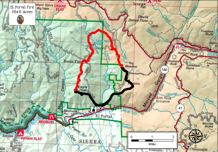
The El Portal Fire remains very active in extremely steep and remote terrain requiring heavy dependence on TYPE 1 hand crews and aviation assets. As with any incident in Yosemite National Park, firefighter and public safety is our number one priority. We appreciate everyone’s assistance with this priority.
- The fire is currently 3,545 acres and 34% contained.
- Resources assigned include 864 Fire Personnel, 7 helicopters and fixed wing as needed
- As of July 29 at 9AM, the evacuation order for Old El Portal was lifted.
- As of July 27, a Type 1 Interagency Management Team, from Southern California, was given command of this fire. The fire is on both NPS lands and Stanislaus National Forest. Joint Unified Command has been established.
- On July 26, at approximately 3:15, the El Portal fire began in the community of El Portal.
Foresta – Fire remains active near community
- Evacuations remain in effect for Foresta.
- Structures in Foresta remain threatened. Two structures have been lost in Foresta – both of which were lost on the first day of the fire, located at the same address.
- Structure protection engines remain in the area.
Campgrounds & Roads Affected – Hwy 120 Remains Open (from Big Oak Flat to Tioga Pass)
- Crane Flat and Yosemite Creek Campgrounds are closed.
- Bridalveil Campground is being used for fire operations and is therefore closed.
- The Big Oak Flat Road is closed between Crane Flat south to the junction of Highway 140. This is a hard closure until further notice for the public, employees and residents.
For More Information
Fire updates for the El Portal Fire are provided by the Type 1 Incident Management Team, working closely with park management. Fire information call center: 209-372-0327 or 209-372-0328.
Additional Fire Activity in Yosemite – all lightning started fires in designated Wilderness
- Dark Hole (647 acres, 5% contained) – managing for minimum impact to wilderness character and is being managed by the Type 1 Interagency Team.
- Mount Starr King (.5 acres) – smoldering and creeping
- Lembert (.25 acres) – smoldering and creeping
- Cathedral (.5 acres) – smoldering and creeping
- Elbow (2 acres) – smoldering and creeping
PDF of fire map [1.91 MB PDF]

