Last updated: March 23, 2021
Thing to Do
View Landmarks along the Santa Fe Trail

NPS Photo
Landmarks
Campsites, springs, and geology served as visual markers and needed stops along the trail. Step back in time and take in a trail view at these sites:
For more location information: Places to Go on the Santa Fe Trail
Sites operating hours and public admittance will vary by location. Some sites may be available to view, but not visit. Please check with the individual site for more specific information.
Pets being allowed will vary by location. Please check with the individual site for more information.
Fees being charged will vary by location. Please check with the individual site for more information.
Accessibility information will vary by location. Please check with the individual site for more specific information. Services animals are allowed at all locations.
Trail Landmarks to Visit
- Santa Fe National Historic Trail
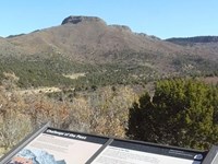
Rabbit Ears Mountain

Rabbit Ears Mountain served as a vital landmark for Santa Fe Trail travelers on the Cimarron Route. Located in North Eastern New Mexico, this largely undeveloped area offers a step into the past. Follow in the footsteps of Trail travelers and use Rabbit Ears Mountain to guide your visit to nearby sites where you will see Trail ruts, campsites, and grasslands.
- Santa Fe National Historic Trail
Santa Clara Cemetery

Wagon Mound is a village in Mora County, New Mexico, United States. It is named after and located at the foot of a butte called Wagon Mound, which was a landmark for covered wagon trains and traders going up and down the Santa Fe Trail. It is now Wagon Mound National Historic Landmark. Santa Clara Cemetery, in Wagon Mound, contains the gravestone of Charles Fraker, a Santa Fe Trail traveler.
- Santa Fe National Historic Trail
Starvation Peak

Starvation peak is butte that sits at over 7,000 feet, located on along Interstate 25 between the town of Pecos and Las Vegas. A prominent landmark to motorists on the highway today, it was also a noted landmark on the Santa Fe Trail. Santa Fe travelers stopping at Bernal Springs would be camping below the towering butte.
- Santa Fe National Historic Trail
Raton Pass

Raton Pass, at the border of present day New Mexico and Colorado, was one of the most important, yet treacherous, segments of the Mountain Branch of the Santa Fe Trail. The pass cut through the snow-capped Sangre de Cristo Mountains, allowing wagons access to the vast western territory. Shorter routes were eventually developed, but Raton Pass, which crossed easier terrain, remained in use.
- Santa Fe National Historic Trail
Santa Fe Spring
- Santa Fe National Historic Trail
Sapling Grove, Overland Park
Since the late 1820s, Sapling Grove, located on the headwaters of Turkey Creek, was a significant campsite on the Santa Fe Trail. George Sibley, an Indian agent who was commissioned to survey the trail in 1825-27, included Sapling Grove on his list of campsites. The park has several interpretive historical markers that discuss 19th century trail activities.
- Santa Fe National Historic Trail
Comanche National Grassland

Several Santa Fe Trail routes coursed through these grasslands, including the Mountain Route, the Granada-Ft. Union Wagon Road, and the Aubry Cutoff. This vast grassland covers more than 440,000 discontinuous acres in southeastern Colorado. It is composed of a large Carrizo Unit near Springfield, along with a smaller Timpas Unit southwest of La Junta. The grassland's headquarters are located at 27204 Highway 287 in Springfield.


