Last updated: October 23, 2023
Lesson Plan
Stepping Off the Map

- Grade Level:
- Upper Elementary: Third Grade through Fifth Grade
- Subject:
- Literacy and Language Arts,Math,Social Studies
- Lesson Duration:
- 60 Minutes
- Thinking Skills:
- Understanding: Understand the main idea of material heard, viewed, or read. Interpret or summarize the ideas in own words. Applying: Apply an abstract idea in a concrete situation to solve a problem or relate it to a prior experience. Analyzing: Break down a concept or idea into parts and show the relationships among the parts. Creating: Bring together parts (elements, compounds) of knowledge to form a whole and build relationships for NEW situations.
Essential Question
Why are maps very important?
How do you make a map?
Objective
Students will be able to use written directions to create a map giving:
• Cardinal directions
• Landmarks and distances
Background
When the Corps of Discovery began its journey across the western reaches of the North American continent, little was known about much of the route. They did know the Missouri River extended far beyond the Mandan villages in present day North Dakota. Information learned in conversations with fur traders and American Indians of the region hinted at the geography of the land, but these details had not been confirmed or the region mapped.
As with so many aspects of the expedition, President Jefferson gave very clear instructions as to what he expected the Lewis and Clark Expedition to accomplish on the expedition and it included faithfully recording the information about this unexplored region.
Taken along on the expedition were maps by such cartographers as Aaron Arrowsmith and Nicholas King. Arrowsmith’s map of the continent showed the Rocky Mountains as a single line of mountains running down the center of the unexplored region and left the remainder of this area blank. King's map included details in dotted lines where he thought rivers flowed or mountains existed. His Rocky Mountain range were somewhat wider than Arrowsmith's, but extended only as far south as today's Colorado. Also carried on the expedition were Alexander MacKenzie's records of his explorations of today’s western Canada.
Even though it had been previously traveled and explored, William Clark was the first to carefully map the Missouri River's course between Camp River DuBois and the Mandan villages. When they departed from their winter encampment site at Fort Mandan, the explorers truly stepped off the map. From this point on, Clark was measuring distances and plotting directions through a landscape never looked at in this way.
Preparation
Print out or display the following handouts:
- Information for Filling in the Blanks
- Filling in the Blanks Map
- Map Comparisons
- Today’s Map of the Lower Columbia River
- Clark’s Map of the Lower Columbia River
- Defining Clark’s Map of Local Area
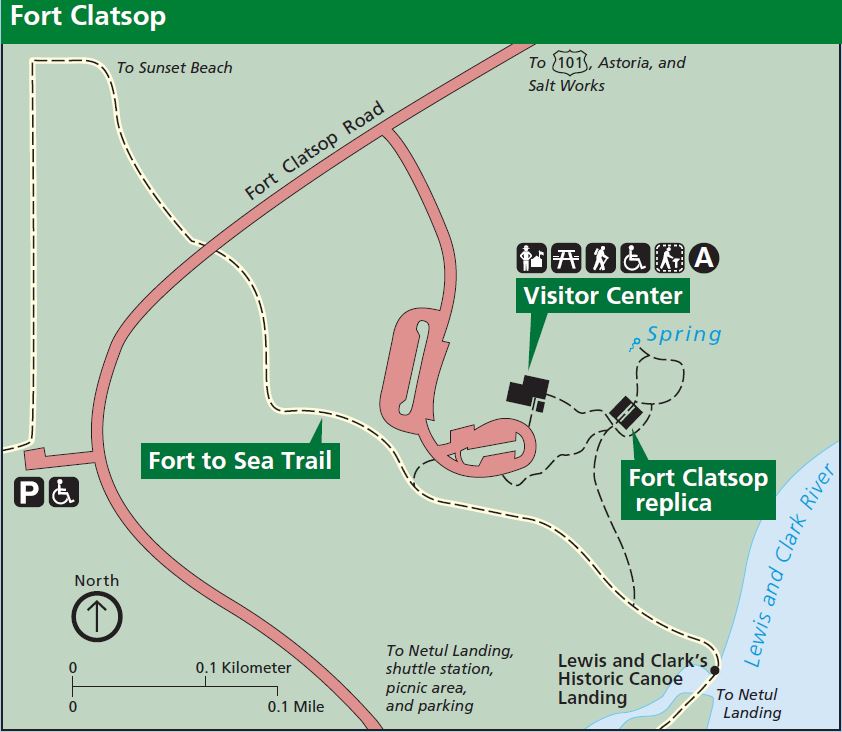
- Map of Fort Clatsop
Materials
Download Information for Filling in the Blanks
Download Filling in the Blanks Map
Download Map Comparison Handout
Download Clark's Map of the Lower Columbia River
Download Today's Map of the Lower Columbia River
Download Defining Clark's Map of Local Area
Procedure
Procedure:
1. Have a group discussion with students as to how and why:
- maps change over time.
- different types of maps are needed, such as road maps, topography maps, etc...
- different types of maps are so important today.
3. Have students compare the two maps Today’s Map of the Lower Columbia River and Clark’s Map of the Lower Columbia River and answer the questions on the handout Map Comparisons.
- Discuss the similarities and differences between these two maps.
- Clark’s Map of the Lower Columbia River - This map has been cleaned up and numbers for the various sites have been added since the original map is no more legible than what is presented here.
- The small numbers on this map correspond to the list on Defining Clark’s Map of Local Area which has legible versions of what Clark wrote on his map.
Assessment Materials
Have the students—working either individually or in groups—follow the directions on the handout Information for Filling in the Blanks to complete Filling in the Blanks Map
- Once the map is completed, have a group discussion about the difficulty or ease the students had with this assignment.
- Show students the actual map of Fort Clatsop found in the Lewis and Clark National Historical Park brochure. Then discuss how their maps differ and the different ways they determined where an object was to be located.