Last updated: September 15, 2023
Lesson Plan
Carving Mountains

- Grade Level:
- Middle School: Sixth Grade through Eighth Grade
- Subject:
- Science
- Lesson Duration:
- 60 Minutes
Essential Question
How do glaciers impact the landscape?
Objective
Students will be able to:
• Compile team dictionaries of mountain and glacial terms.
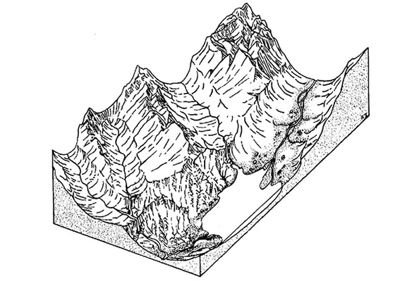
• Work cooperatively to design and build a mountain range out of clay that contains glacial features.
• Optional: build models to scale.
• Identify landforms in their clay models that have cultural significance.
Background
Make glacial feature labels and or definition cards for each group. Have boards/trays for models to be built on, clay ready and place to put models out. This activity is designed to get students research experience on glaciers and the tactile experience of building a scale model of mountains with glacially carved features. View the Carving Mountains Instructional Video.
This lesson is one unit of the Work House: A Glacier National Park Science and Indian Education Program. It can be completed as a stand alone lesson or as part of the greater Work House course.
The full Work House Program is available on Glacier National Park's website.
Background information as well as the full lesson plan can be found as a PDF here.
Preparation
- Two class periods - one to do research on glacial terms. The second to construct clay models. Additional time if students want to paint or use models for other presentations.
- Watch the Carving Mountains Instructional Video
- Research materials to include Earth Science texts, books dealing with the geology of Glacier National Park and Montana
- Images of geological features of Glacier National Park
- One or more raised relief maps of Glacier National Park
- Paper for recording research
- Several recycled 4’ by 4’ plywood boards
- Moist, recycled pottery clay or large supply of modeling clay
- Tools for working clay
- An appropriate ruler to establish a reference scale for elevations
- Paper or light cardboard for labels
- Pins to hold labels
- Scissors
- Fine-point pens
- Plastic covering to prevent drying out of models in general
- Good dictionary
Procedure
- Use the vocabulary list provided (and add others of your choosing) as a guide for students to use in compiling team dictionaries of mountain and glacial terms.
- Divide the students into cooperative learning groups; give each group fresh balls of clay and tell them to sculpt mountain formations on a team board until they are satisfied with what they have done. It will add relevance if students are encouraged to replicate an area of the park with which they are familiar. The raised relief maps of the park are a great resource for this. A math component can be added if students must do it to scale! (1 inch = 1000 feet elevation for example, so a 10,000 foot peak would be 10 inches high).
- Provide glacial feature labels (or definition cards) to an appointed or chosen chairperson for each team. Ask individuals to identify or remold specific features into the group of mountains. This requires alterations of the original mountains. When there is some question about a formation to be labeled, students may use available books and other resources for immediate research.
Extensions
Writing Extension: Using the vocabulary and other terms they came across in their research, each team should generate a dictionary definition of mountain and glacial terms. When dictionaries are completed, students should examine other teams’ models and help each other refine formations and definitions. This process will help them to internalize their research. The next obvious question might be, “What do we do with the clay models when the students finish?” Ask the students! Maybe they would like to paint them, show them to another class or parents, write an adventure story that takes place in the mountains, generate some appropriate weather in their models, pour water over them to trace natural drainage, or make models of indigenous animals and plants to put in their created environments.
Field Trip Extension:
- Ranger-Led Field Trips and Service Learning Projects in Glacier National Park. Earth Science and Forest Processes field trips about park geology.
- Self-Guided Field Trips as well as Guided Tours - various concession operated - in Glacier National Park.
- Glacier Institute - geology and other education programs.
- Guided Tours in Glacier National Park- various concession operated.
Vocabulary
Alpine meadow, avalanche, col, crevasse, esker, fold, glacial trough, glaciation, hanging valley, kettle lake, lateral moraine, medial moraine, moraine, mountain pass, mountain range, outwash plain, peak, plateau, terminal moraine, tree line, valley glacier.
Assessment Materials
When the labeling and remolding are complete, the students should be able to define and discuss their work.
Additional Resources
- Climate Change Resource Guide.
- USGS Repeat Photography Project and Repeat Photo Education Trunk.
- Ice Patch Archaeology Resource Brief
- Glacier National Park Ice Patch Project Interactive Website with Kids Page - Confederated Salish and Kootenai Tribes of the Flathead Reservation, the Blackfeet Nation, the Univ. of Wyoming, Univ. of Colorado Boulder, Univ. of Arizona, Glacier National Park’s cultural resources program and the Rocky Mountains Cooperative Ecosystem Studies Unit (CESU).
- Flathead Community of Resource Educators Website - contains a resource link to the Flathead Watershed Sourcebook - which contains cultural and natural history of the Flathead watershed.
- Glacier National Park Conservancy Bookstores - books specific to Glacier.
- Tall Tales, Mechanical Weathering, Glacier Features, Mountain Names, OPI-Indian Education for All Lesson, 5th grade.
