Last updated: February 17, 2022
Lesson Plan
Cartography: Map Making and Red River Campaign of 1864 Battle Plans

- Grade Level:
- High School: Ninth Grade through Twelfth Grade
- Subject:
- Math,Social Studies
- Lesson Duration:
- 30 Minutes
- Thinking Skills:
- Understanding: Understand the main idea of material heard, viewed, or read. Interpret or summarize the ideas in own words. Evaluating: Make informed judgements about the value of ideas or materials. Use standards and criteria to support opinions and views.
Essential Question
How can shared observations and indirect communication affect the quality and accuracy of the information being transmitted?
Objective
1. The learner will draw a Civil War battle map from oral directions.
2. The learner will analyze the sequence of events of the Red River Campaign 1864.
Background
“On the eve of the Civil War, few detailed maps existed of areas in which fighting was likely to occur. Uniform, large-scale topographic maps, such as those produced today by the US Geological Survey, did not exist and would not become a reality for another generation. In most cases, the best medium-scale, published maps available in 1861 were those sponsored by various state legislatures.”
“The most detailed maps available in the 1850s were of selected counties…commercially produced wall maps showed roads, railroads, towns and villages, rivers and streams, mills, forges, taverns, dwellings, and the names of residents.”
United States / Union Mapping
“Federal military authorities were keenly aware that they were unprepared to fight a war on American soil. Any significant campaign into the seceding states could be successfully carried out only after good maps, based on reliable data from the field, had been prepared. Existing federal mapping units, such as the Army’s Corps of Topographical Engineers and Corps of Engineers…were considered of immense importance to the war effort and were given full support to expand and carry out their missions. Although Federal authorities were unprepared to fight a war, they had one great advantage over the Confederacy: they were able to build upon an existing organizational structure, which included equipment and trained personnel.”
Confederate Mapping
“The Confederate Army had difficulty throughout the war in supplying its field officers with adequate maps. The situation in the South was acute from the beginning of hostilities because of the lack of established government mapping agencies capable of preparing large-scale maps, and the inadequacy of reprinting facilities for producing them. The situation was further complicated by the almost total absence of surveying and drafting equipment, and the lack of trained military engineers and mapmaker's to use the equipment that was available.”Information above was adapted from http://memory.loc.gov/ammem/collections/civil_war_maps/cwmpostm.html
The Red River Campaign of 1864
The Union Army in Louisiana in 1864 had three main objectives to complete with the Red River Campaign. The first goal was to capture as much Confederate cotton as possible. Second, capture the temporary state capital of Shreveport. Shreveport produced many war related goods for the Confederacy, such as ironclad boats and submarines. Third, was to invade Texas, the last large provider for the Confederacy of men, horses, and food, much of which came from Mexico. The Union Brigadier General of the operation, Nathaniel Banks, had a two part plan to complete the mission. The first part of the strategy was to make a major thrust up the Red River. Second, the Union army stationed in Little Rock, Arkansas would march to Shreveport. In March of 1864, the campaign began with General Nathaniel Banks and 20,000 men marching north from Bayou Teche and Union Admiral David Porter with a large fleet of ships and 10,000 sailors sailing up the Red River. Over the next week the Union sailors stripped the countryside of Confederate cotton (or what was not burned by the planters themselves to keep the Union from getting their cotton), claiming it for the US Navy. In April of 1864, Banks and Porter reached the large port of Grand Ecore, just north of Natchitoches. Porter continued upriver and Banks marched towards Shreveport by the way of Mansfield. Confederate General Richard Taylor launched an all out attack just outside of Mansfield – one of the largest battles west of the Mississippi River. The Union sorely lost the Battle of Mansfield, but it saved Shreveport for the Confederacy. General Banks was shocked that the Confederates had attacked before they had reached Shreveport. The Union Army retreated and was going to regroup in Pleasant Hill, but was attacked the next day. The Battle of Pleasant Hill was technically a Union victory, but Banks decided to retreat anyway.While Banks was fighting in Mansfield and Pleasant Hill, Admiral Porter and his boats continued up towards Shreveport. Just past Coushatta, in Loggy Bayou, the Confederates had blocked the Red River with sunken steam boats. Porter and his fleet had to turn the boats around and retreat to Alexandria.The Union retreat quickly became a frenzy of burning and looting along the Red River and Cane River. The destruction of civilian homes and property was not ordered, but not discouraged either. When Banks’ army finally retreated from the city of Alexandria, the soldiers burned the city to the ground. Twenty-two city blocks were destroyed and scores of civilians had to jump into the Red River to escape the flames. The Red River Campaign was a disaster for the Union. None of the campaign’s goals were achieved, numerous ships were lost, and thousands of men were dead, wounded, or captured. For the people of Louisiana, it was the most destructive campaign of the entire war.
Information adapted from Jones, Terry L. Ph.D. The Louisiana Journey. Layton, Utah; Gibbs Smith Publishing, 2007.Preparation
Materials Needed:
- Magnetic Compass
- Drawing Compass
- Rulers
- Reproduction Maps from the Battles of Gettysburg, Fort Donelson, and Chickamauga (Optional)
- Two Examples of Hand drawn Maps
- Battle of Mansfield Map Directions Handout
- White paper
- Writing tools / various colors
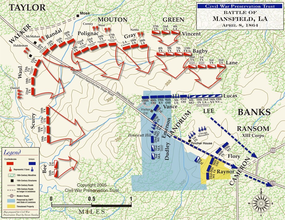
Materials
Image Description: A map showing the Battle of Mansfield as described in activity. US / Union troops are shown in blue (lower half of map) and Confederate shown in red (upper half)
Procedure
Battle of Mansfield Map Directions
Turn your paper so the longer sides are on the top and bottom (landscape).
- You are going to draw a map of a battlefield. The top side of your paper will represent the north side of the battle field. The scale of your map is 1 inch equals 1 mile. Make a legend: Blue triangle = Union Artillery; Blue Circle = Union Cavalry; Blue Rectangle = Infantry; Red triangle = Confederate Artillery; Red Circle = Confederate Cavalry; Red Rectangle = Confederate Infantry
- Write the Title of the Map at the bottom center (The Battle of Mansfield April 8, 1864).
- Measure 1 inch from the bottom Southeast corner of the map and make a mark, then measure 2 inches from the Northwest corner of the map. Connect these two dots with a brown road. Label the road “Old Stage Road”.
- Draw a rail fence represented by a brown zigzag line two miles from the Northwestern corner along the south side of Old Stage Road. After 2 miles, take the fence due South to the edge of the map. Label rail fence.
- Draw a rail fence represented by a brown zigzag line two miles from the Northwestern along the north side of Old Stage Road. After 2 miles, take the fence due East to the edge of the map. Label rail fence.
- Measure 4 miles northwest from the southeast corner of the map. Draw a creek flowing north, and make it veer northeast after it crosses the road.
- Draw a 2 inch by 3 inch oval in the middle of the page in green representing a hill. Label the formation “Honeycutt Hill”.
Place the following Union regiments:
- Infantry regiment: 1 mile in the middle of the road from the south east corner facing northwest.
- 2 Infantry regiments: 1 mile further, on the south side of the road in the field facing northwest
- 2 Infantry regiments: Opposite on the north side of the road, facing northwest
- 2 Cavalry regiments: 2 miles further on the road, facing northwest
- 3 Artillery regiments: directly south of the museum on the road
- 4 Cavalry regiments: south of the artillery regiments, on Honeycutt Hill
- 1 Infantry regiment: directly north of the museum
- 7 Infantry regiments: from the last regiment along the fence line going eastward, facing north
- 4 Cavalry regiments: place south of 7 infantry regiments at the fenceline2
- 2 artillery regiments: place south of the 4
Place the following Confederate regiments:
- 4 infantry regiments: South of Old Stage Road along the western side of the rail fence facing eastward.
- 2 artillery regiments: behind the 4 infantry regiments that you just drew.
- 1 Infantry regiment: 2 miles from the northwest corner of the road on the north side of the fence, facing south east.
- 4 cavalry regiments: eastward from the previous infantry unit
- 4 infantry regiments: put one regiment immediately north of the last four cavalry regiments
- 4 cavalry regiments: put one regiment immediately north of the last four infantry regiments.
- The Confederate were on the offensive. Draw arrows going towards the union troops from the Confederate troops.