Mission San José de Tumacácori-- Spanish Colonial Missions of the Southwest Travel Itinerary

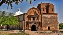
Mission San José de Tumacácori — at Tumacacori National Monument Photograph courtesy of Jsweida under the Createive Commons license

Mission San José de Tumacácori
Tumacácori National Historical Park, Arizona
Coordinates: 31.562638, -111.050008
#TravelSpanishMissions
Discover Our Shared Heritage
Spanish Colonial Missions of the Southwest Travel Itinerary
Mission San José de Tumacácori
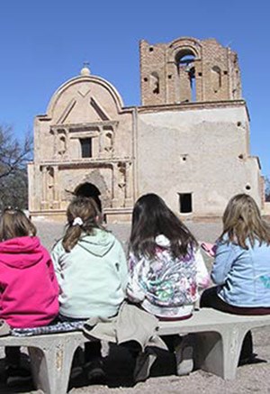
Today, Tumacácori is visited by thousands of people every year.

Courtesy of the National Park Service.
Founded by Jesuit Father Eusebio Francisco Kino in January 1691, Mission San Cayetano de Tumacácori was the first mission to be located in what is now Arizona, and was part of the global Spanish mission system of colonization that attempted to create a self-sufficient agricultural community, convert local Indians to the Catholic religion, and generate revenue for Spain. Originally located on the east side of the Santa Cruz River, the mission moved, following the Pima Revolt in 1751, to its present location on the west side of the river. The mission was then rechristened San José de Tumacácori.

By 1757, the community had built a small adobe church. Following the expulsion of the Jesuits from the Spanish empire in 1767, the Franciscan order took over management of the Pimería Alta missions. Around 1800, the community began construction of a larger church. Although in use by the early 1820s, the building was never entirely completed. Apache raids and other stress factors in the 1840s eventually led to the abandonment of Tumacácori in December 1848. The inhabitants moved to Mission San Xavier del Bac, just south of Tucson.

Today, Mission San José de Tumacácori is a popular tourist destination administered as part of Tumacácori National Historical Park. The mission church building is maintained in a state of arrested ruin, with the goal of preserving the original structure rather than additional restoration or speculative completion of architectural features.

The native people who lived in the region around Tumacácori called themselves "O'odham," meaning "people" in their language. They were known in the past by the problematic colonial terms Pima and Papago. Their homeland included the area that is now Southern Arizona and the northern part of the Mexican state of Sonora. The O'odham were farmers, raising corn, beans, squash and other crops using flood irrigation long before the Spanish came. The people called "Papago" by the Spanish are known today as the Tohono O'odham, or "desert people," and continue to live and farm in southern Arizona. People from other indigenous groups lived at and around the mission as well, including Yaqui, Apache, Yuman, and Opata, in addition to the mission priests who originated from various parts of Europe and the Americas. Disease often spread in waves ahead of the Spaniards, decimating native villages before Spaniards arrived, but the native peoples of Southern Arizona were resilient, surviving disease and European and American colonialism.
Mission San José de Tumacácori
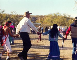
O'odham Circle Dance at the Fiesta de Tumacácori held at the park annually.

Courtesy of the National Park Service.

"Open Territory with Good Lands"

Missions were often established near existing Indian villages. The mission grounds were an institutionalized landscape with a highly defined spatial pattern that divided and separated land for religious use, priest quarters, specialized work areas, Christianized Indian quarters, mission agricultural/livestock lands, orchards and irrigation ditches, or acequias. Native settlements around the mission consisted of large villages of mud and brush houses and numerous smaller scattered villages and extended family habitations. Wheat was the primary agricultural crop, followed by corn. The O'Odham adopted winter wheat from the Spanish. It became important to their diet and could be harvested in what previously had been a lean time of the year. Archeologists have found large numbers of bowls for soups and stews and flat ceramic comales used to make tortillas.

Ranching was also an important part of mission life, and with herds of thousands of cattle and sheep, the people at the mission likely kept busy shearing, herding, and butchering these animals. The acequia fed orchards and fields where a large number of domesticated plants like wheat, maize, squash, watermelon, cantaloupe, lentils, peppers, and peaches were grown. In recent years, the National Park Service has conducted fieldwork within the orchard area, locating foundations of the walls that once surrounded the orchard and the compuerta, or washing basin. The compuerta of the historic acequia served as a weir that consistently raised the depth of upstream water within the canal for diversion into the surrounding fields and gardens.

Abandoned in 1848 under pressure of Apache raiding, Tumacácori began falling into disrepair during the American period in Arizona. Tumacácori became a National Monument in 1908, and part of the National Park Service in 1916, but had no resident ranger until 1929. Archeological and preservation work at the mission began in 1917, with excavations by Frank Pinkley who also installed a roof over the adobe church.
Mission San José de Tumacácori
Mission San José de Tumacácori, profile of the church and the granary.

Photo by Ammodramus. Courtesy of Wikimedia Commons.
What you can see today

The Franciscans began work around 1800 on an ambitious undertaking - a church that would match the frontier baroque glory of the celebrated Mission San Xavier del Bac not far to the north. Under the direction of a master mason, a crew of Indian and Spanish laborers laid five-foot thick cobblestone foundations that year, but construction ground to a halt as funds dried up. Over the next few years, they were able to add a few courses of adobe bricks. It was not until 1821 that work truly resumed. The church was almost completed in 1822. The ruins of the large church remain a landmark in the Santa Cruz Valley, with its 9ft thick adobe walls to support the bell tower and the choir balcony. Attached to the main church are the baptistery and the sacristy. Nearly everything with the exception of the roof and the floor of the church is original. Some of the original decorations on the interior of the cupola in the sanctuary are still visible today.
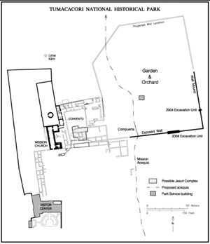
Nearby the church are the remains of the priest's residence and community area known as the convento, enclosing a large plaza where many of mission's main activities took place. The large adobe structures required constant maintenance, and in the area around the quadrangle, archeologists have found large pits where local soil was mined to make adobe. Visitors can also see the large lime kiln used for the unpleasant job of heating lime to make mortar and plaster for the buildings. Lime helped preserve the adobe by protecting it from moisture. Behind the church are the ruins of a cemetery and the round mortuary chapel. Originally, this mortuary chapel was supposed to have a domed roof, but construction of that apparently never began, so the resulting incomplete structure is (and apparently always has been) open to the sky. Also on the site is a reproduction of a ki, or traditional O'odham house, much like the ones the O'Odham would have lived in around the mission. Visitors can also walk by the compuerta and the historic mission garden/orchard.
Mission San José de Tumacácori
Plan view of the Tumacácori mission complex.

NPS map. Courtesy of the National Park Service.

Tumacácori National Historical Park in Southern Arizona protects the ruins of three missions founded during the Spanish colonial era. The park preserves and tells the stories of these Spanish missions and their influence on the American Indian communities of the Pimería Álta and on the continuing culture of the American Southwest. Visitors enter Tumacácori National Historical Park through the Tumacácori visitor center. The visitor center offers a 15 minute video, an excellent museum, and a bookstore. Guided tours are available at 11:00 and 2:00 January through March, and may be available at other times and seasons. Special tours, such as guided walks to the Santa Cruz River, may also be available. The park website describes tours currently offered.

Tumacácori National Historical Park hosts La Fiesta de Tumacácori each year on the first full weekend in December. This event celebrates the many cultures that have historically been associated with the Santa Cruz Valley with traditional foods, crafts, music, and dance. The Juan Bautista de Anza National Historic Trail passes through the park, providing opportunities for walkers, bird watchers, and equestrians.

Plan Your Visit

Tumacácori National Historical Park, a unit of the National Park System is located 45 miles south of Tucson, AZ off exit 29 on I-19. The visitor center for the Tumacácori National Historical Park is located at 1891 East Frontage Rd., Tumacácori, AZ and is open 9:00am to 5:00pm daily, except Thanksgiving Day and Christmas Day. Click here for the National Register of Historic Places file: text and photos. There is an admission fee. For more information, visit the National Park Service Tumacácori National Historical Park website or call 520-377-5060. The Juan Bautista de Anza National Historic Trail passes through Tumacácori; please visit their website for information on sites along the 1,200-mile trail that connects history, culture, and outdoor recreation across 20 counties of Arizona and California.
Tumacácori National Historical Park is also featured in the National Park Service Places Reflecting America's Diverse Cultures: Explore their Stories in the National Park System Travel Itinerary and the American Latino Heritage Travel Itinerary.

Last updated: April 15, 2016

Tools

  • Site Index