Directions & Transportation

 
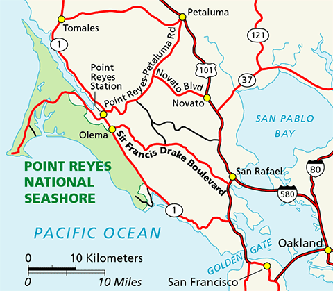
A color map of Marin County and the northwest San Francisco Bay Area with Point Reyes National Seashore shown in green on the left side of the map.

Point Reyes is located along the west coast of California approximately thirty miles (fifty km) north of San Francisco off of Highway 1 (see Maps). Travelers may approach the park from the winding scenic Highway 1, either northbound or southbound. Visitors can also reach the park via Sir Francis Drake Boulevard or the Point Reyes-Petaluma Road.

Below are directions for the quickest routes to Point Reyes National Seashore's Bear Valley Visitor Center from San Francisco, the East Bay, Sacramento, and Petaluma. For directions from the Bear Valley Visitor Center to points of interest and trailheads within Point Reyes National Seashore, please visit our Directions to Park Destinations page.

Public Transportation

Public transportation to the Bear Valley Visitor Center from San Rafael along Sir Francis Drake Boulevard is available through the West Marin Stagecoach.

Parking at Bear Valley

On weekends and holidays, the paved parking lot adjacent to the Bear Valley Visitor Center can fill early, especially if visitors who are spending more than thirty minutes in the Bear Valley area park in the paved lot. To help reduce traffic congestion in the paved parking lot, day hikers, backpackers, and other visitors who will be spending an extended period of time (i.e., more than thirty minutes) in the Bear Valley area are encouraged to park their vehicles in the gravel parking lot on the left (east) side of the access road close to the Bear Valley Trailhead. (Download the Bear Valley Area Map [504 KB PDF])

Other Useful Information

Alternative Fuel Vehicles

RVs and Trailers

Road Closures in Point Reyes National Seashore

Directions Using GPS or Internet Mapping Applications

Top of Page


Directions from San Francisco

  • From San Francisco, go north on U.S. Highway 101 across the Golden Gate Bridge.
  • Follow U.S. 101 about 9 miles (14 km) north of the Golden Gate Bridge to the Sir Francis Drake-San Anselmo exit, exit 450B.
  • Make sure you are in the lane for San Anselmo (the second lane from the right) and exit onto Sir Francis Drake Boulevard heading west.
  • Follow Sir Francis Drake west approximately 21 miles (33 km)—passing through San Anselmo, Fairfax and Samuel P. Taylor State Park—until it intersects with Highway 1 at Olema.
  • Turn right on Highway 1 and proceed north about 0.1 miles (0.2 km) to the intersection with Bear Valley Road.
  • Turn left onto Bear Valley Road and head west about 1/2 mile (0.8 km). Look for a big red barn on the left and a sign for "Visitor Center; Headquarters; Information" on the right with an arrow pointing left.
  • Turn left after passing by the red barn and proceed up the left-fork of the access road to the Bear Valley Visitor Center, the park's primary contact station.

Top of Page


Directions from the East Bay (San Francisco Bay Area)

  • Follow Interstate 580 west across the Richmond-San Rafael Bridge.
  • Shortly after the bridge, take the Sir Francis Drake Blvd. exit (the second exit after the bridge).
  • Follow Sir Francis Drake west approximately 22 miles (35 km)—passing through San Anselmo, Fairfax and Samuel P. Taylor State Park—until it intersects with Highway 1 at Olema.
  • Turn right on Highway 1 and proceed north about 0.1 miles (0.2 km) to the intersection with Bear Valley Road.
  • Turn left onto Bear Valley Road and head west about 1/2 mile (0.8 km). Look for a big red barn on the left and a sign for "Visitor Center; Headquarters; Information" on the right with an arrow pointing left.
  • Turn left after passing by the red barn and proceed up the left-fork of the access road to the Bear Valley Visitor Center, the park's primary contact station.

Top of Page


Directions from Sacramento

  • Follow Interstate 80 about 50 miles (80 km) west toward Vallejo.
  • Take Exit 33B to head west on California Highway 37 toward Novato/San Rafael.
  • Be sure to merge into the left lane of the off-ramp, because the right lane quickly becomes an exit lane off of Highway 37.
  • From Interstate 80, follow California Highway 37 west about 19 miles (30 km).
  • Take the Black Point/Atherton Avenue exit, which is about 1 mile (1.6 km) past the bridge over the Petaluma River. At the stop sign, turn left onto Atherton Avenue.
  • Follow Atherton Avenue west 3.2 miles (5.1 km). As the road crosses Highway 101, it becomes San Marin Drive. Continue west for about 2.5 miles (4 km) to the junction with Novato Blvd.
  • Turn right onto Novato Blvd. and proceed west for about 6 miles (10 km) to the Point Reyes-Petaluma Road.
  • Turn left and follow the Point Reyes-Petaluma Road southwest toward Point Reyes Station for about 7 miles (11 km) to the junction with Platform Bridge Road.
  • Continue straight onto Platform Bridge Road and wind your way south for 2.4 miles (3.8 km) to the junction with Sir Francis Drake Boulevard.
  • Turn right onto Sir Francis Drake Boulevard and drive west for 1.8 miles (2.9 km) to the intersection with Highway 1 at Olema.
  • Turn right on Highway 1 and proceed north about 0.1 miles (0.2 km) to the intersection with Bear Valley Road.
  • Turn left onto Bear Valley Road and head west about 1/2 mile (0.8 km). Look for a big red barn on the left and a sign for "Visitor Center; Headquarters; Information" on the right with an arrow pointing left.
  • Turn left after passing by the red barn and proceed up the left-fork of the access road to the Bear Valley Visitor Center, the park's primary contact station.

Top of Page


Directions from Petaluma

  • From Highway 101, take the East Washington Street exit in Petaluma.
  • Follow East Washington Street southwest about 0.6 miles (1 km) to Lakeville Street.
  • Turn left and proceed southeast one block to D Street.
  • Turn right onto D Street, which will become the Point Reyes-Petaluma Road, and head southwest for about 16 miles (25 km) to the junction with Platform Bridge Road.
  • Continue straight onto Platform Bridge Road and wind your way south for 2.4 miles (3.8 km) to the junction with Sir Francis Drake Boulevard.
  • Turn right onto Sir Francis Drake Boulevard and drive west for 1.8 miles (2.9 km) to the intersection with Highway 1 at Olema.
  • Turn right on Highway 1 and proceed north about 0.1 miles (0.2 km) to the intersection with Bear Valley Road.
  • Turn left onto Bear Valley Road and head west about 1/2 mile (0.8 km). Look for a big red barn on the left and a sign for "Visitor Center; Headquarters; Information" on the right with an arrow pointing left.
  • Turn left after passing by the red barn and proceed up the left-fork of the access road to the Bear Valley Visitor Center, the park's primary contact station.

Top of Page


Alternative Fuel Vehicles

Do you plan to travel to the park in an alternative fuel vehicle? If so, good for you! Your actions help us reduce petroleum use and reduce greenhouse gas emissions that are contributing to anthropogenic climate change. Plan your trip with the Alternative Fueling Station Locator from the Department of Energy (search on zip code 94956) and visit our Electric Vehicle Charging Stations page to learn where you can charge your vehicle within Point Reyes National seashore.

Top of Page


RVs and Trailers

Some of the park's roads and parking lots are closed to or do not have space for recreational vehicles (RVs) and vehicles pulling trailers. While there may appear to be sufficient parking space early in the morning at some of the smaller parking lots, the parking lot can quickly fill. On a number of occasions, RV drivers have parked in a lot and by the time the driver returned to depart, the parking lot was full and there wasn't sufficient room to maneuver the RV out of the parking lot without damaging other vehicles. Not until much later, after the parking spots adjacent to and in front of the RV were cleared, was the driver of the RV able to safely get the RV out of the parking space and out of the lot. Some visitors who arrived during this time and were told by the driver of the RV (and later by park staff) that they couldn't park in the parking lot, even though there were parking spaces apparently available, weren't too happy.

If you are traveling with a trailer or are driving an RV towing a passenger vehicle, consider unhitching at the bus/RV/trailer-only parking lot at Bear Valley and taking only the passenger vehicle for the drive out to the Lighthouse area.

Overnight parking/camping in RVs and trailers is prohibited throughout Point Reyes National Seashore. Visit our Nearby Campgrounds page for alternatives.

Top of Page

Last updated: May 7, 2024

Park footer

Contact Info

Mailing Address:

1 Bear Valley Road
Point Reyes Station, CA 94956

Phone:

415-464-5100
This number will initially be answered by an automated attendant, from which one can opt to access a name directory, listen to recorded information about the park (e.g., directions to the park; visitor center hours of operation; fire danger information; wildlife updates; ranger-led programs; seasonal events; etc.), or speak with a ranger. Please note that if you are calling between 4:30 pm and 10 am, park staff may not be available to answer your call.

Contact Us