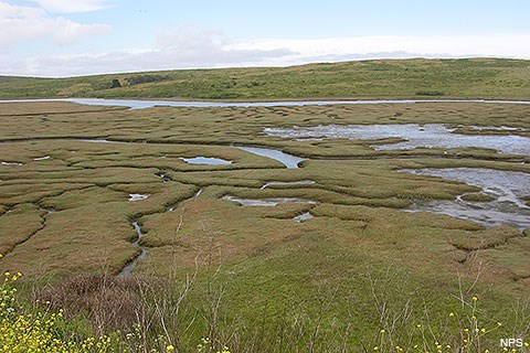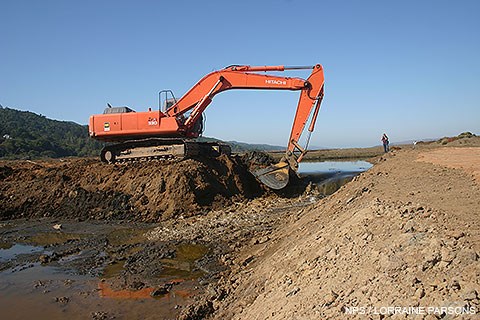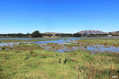
Where freshwater streams meet saltwater, they form estuaries—one of the most fertile habitats on earth. These rich habitats provide spawning grounds for crabs and numerous fish species, and are a vital stopping point for migratory ducks and shorebirds as they fly thousands of miles up and down the Pacific Flyway. The shores of an estuary are often fringed with wetlands—a generic term used to describe a variety of habitats where the land is at least sometimes covered with water. Salt marshes are a particular kind of wetland that occurs in saline environments, like near estuaries or bays. Common freshwater wetlands can include marshes and swamps. Another type of wetland habitat is riparian habitat, which is found along streams and lakes and typically supports verdant stands of water-loving plants. In all of these kinds of wetlands, submerged and partially submerged vegetation provide food and refuge for a myriad of species, and also capture sediment and pollutants. Wetlands play an important role in the health of aquatic and terrestrial ecosystems. They provide valuable functions for humans and wildlife such as storing floodwaters, dissipating energy of flood flows, improving water quality, providing habitat and food for wildlife, as well as providing recreational opportunities and support of mariculture and fisheries industries. Loss or degradation of wetlands eliminate or substantially reduce the potential for wetlands to serve some of these important functions. Land development has claimed much of the wetland habitat in the Bay Area, but a number of restoration projects, including those spearheaded by the National Park Service and its partners at Drakes Estero, Estero de Limantour, and the Giacomini Wetlands, are attempting to reverse that trend. Lower Glenbrook Quarry Restoration & Dam Removal at Turney PointPoint Reyes National Seashore completed the Glenbrook Quarry Restoration and Dam Removal Project within the Estero de Limantour during the week of October 5, 2009. The 15-foot high, 600-foot long Lower Glenbrook Dam was constructed in 1960 with material mined from the adjacent hillslopes and failed in 1982 during a major storm event. Contractors removed approximately 19,000 cubic yards of the former dam, using that material to restore the abandoned mine land features within Wilderness. The excavation of the remaining dam from the estuary restored a priority abandoned mine land site and removed a non-conforming structure from the Phillip Burton Wilderness. The project reestablished the natural hydrologic and shoreline regime in Limantour Estero, part of the Phillip Burton Wilderness. Limantour Estero is a biologically rich estuary that was recently designated a Marine Reserve through the California Marine Life Protection Act. 

Left image
Right image
Removal of the fill from the estuary returned natural hydrologic conditions to the estuarine habitat at Point Reyes National Seashore by removing remaining infrastructure which impeded the development and function of the tidal marshplain. The project area is subject to sea level rise and restoration of natural process within this estuary is a climate change adaptation strategy to ensure maintenance of a healthy and functional estuarine ecosystem. Funding for this project was provided through the NPS Abandoned Mine Lands program, the Bella Vista Foundation, and Point Reyes National Seashore Association. The Restoration of the Lower Glenbrook Quarry and Dam Removal at Turney Point Environmental Assessment examined alternative means to restore natural hydrologic function and assessed the potential environmental effects of the implementation of each strategy. This Environmental Assessment addressed removal of the remnant portions of the Lower Glenbrook Dam, which breached in 1982, and restoration of the adjacent spillway and quarry areas used to construct the original dam. The remains of the dam and disturbed lands associated with the quarry and spillway were considered a non-conforming structure in the Philip Burton Wilderness. The project is intended to restore natural conditions and enhance estuarine habitat in this portion of Drakes Estero. The project did not result in habitat conversion and was consistent with other restoration efforts in the park such as the Coastal Watershed Restoration and Giacomini Wetland Restoration. This Environmental Assessment evaluated the potential environmental consequences of three alternative strategies for implementing the Lower Glenbrook Quarry and Dam Removal at Turney Point Project. The public comment period for the project EA closed February 22, 2008. As a result of the public review process and consultation with regulatory agencies the National Park Service determined that this project would not result in significant impacts. A Finding of No Significant Impact (FONSI) was completed and signed by the acting Regional Director on May 19, 2008. Point Reyes National Seashore Completes Restoration within the Phillip Burton Wilderness - October 9, 2009 (157 KB PDF) Glenbrook Quarry Restoration and Dam Removal: Restoring Natural Process in the Phillip Burton Wilderness slideshow - October 9, 2009 (7,611 KB PDF) Giacomini Wetland Restoration ProjectIn the 1940s, the Giacomini family, with the support of the Army Corps of Engineers, had constructed a system of levees at the head (e.g., south end) of Tomales Bay, in order to "reclaim" land and convert the wetlands into pasturelands. However, the levees dramatically reduced floodwater retention in the floodplains of Lagunitas Creek and Tomasini Creek, with the levees along Lagunitas Creek potentially exacerbating flooding of adjacent private properties. Removal of riparian vegetation on levees had also decreased the ability of riparian systems to dissipate the energy of flood flows, leading to faster, more turbulent, and erosive flows. In Olema Marsh, steadily increasing water surface levels created by poor drainage of Bear Valley Creek flows had not only reduced the potential volume of floodwater that can be stored, but increased flooding of adjacent county roadways, such as Levee Road (the locals' name for Sir Francis Drake Boulevard between Point Reyes Station and Inverness Park) and Bear Valley Road. In 2000, the National Park Service acquired the Waldo Giacomini Ranch at the head (e.g., south end) of Tomales Bay for the purpose of wetland restoration using a combination of Congressional appropriations and mitigation monies from the California Department of Transportation. While the Giacomini Ranch and Olema Marsh, by 2000, were largely wetland and home to at least two federally listed threatened or endangered species, their value to the larger Lagunitas Creek and Tomales Bay ecosystems had been greatly diminished by land degradation and the lack of hydrologic connectivity. Wetlands on the Giacomini Ranch largely consisted of expanses of wet pasturelands created through seeding of nonnative grasses and herbs. With such low biodiversity, the pasturelands lacked the structural habitat diversity so important to wildlife. The conversion of Olema Marsh to freshwater marsh through diking had ostensibly increased its attractiveness to some wildlife species, such as waterbirds, but it had likely also displaced species that could have historically occurred in the transitional zone between fresh and salt water, such as the federally listed endangered species, tidewater goby (Eucyclogobius newberryi). 
From 2000 to 2008, the National Park Service, with its partners, engaged the public in the planning process for the restoration of the Giaocomini Wetlands. Construction of the restoration component of the Giacomini Wetland Restoration Project was implemented in two principal phases-Phase I in fall 2007 and Phase II in summer and fall 2008. Phase I, which spanned from September 2007 through December 2007, principally involved removal of agricultural infrastructure and conditions and creation of special status species habitat. The second and largest phase of the project was Phase II, which ran from July 2008 through December 2008. Phase II focused on marshplain and floodplain restoration, with the climax occurring on October 26, 2008, when levees were breached, allowing salt water to flow across an area from which it had been excluded for decades. Visit our Giacomini Wetland Restoration Project: Summary of Construction Under Phase I and II page to learn more details. 
Construction efforts aimed at restoring the former Waldo Giacomini Ranch to wetland were largely complete as of December 2008. However, this did not mean that restoration or construction was entirely complete. Additional construction may occur in future years in the Giacomini Ranch and Olema Marsh should additional funding become available. These restoration activities include continued restoration of hydraulic connectivity in Olema Marsh and further lowering of high elevation areas in the Giacomini Ranch, as well as continued treatment and retreatment of non-native invasive plant species. Restoration, too, is an ongoing process. While the bulldozers and excavators may be gone, the process of restoring these diked and altered systems to fully functional marshes is just beginning and will continue to unfold into the future. Please visit our Restoration web pages for updates and information on the status of the restoration process. Coastal Watershed Restoration ProgramThe Coastal Watershed Restoration Program was launched in the early 2000s to restore five coastal watersheds within Point Reyes National Seashore's wilderness area. The objective was to remove and restore physical impediments and correct abandoned roads associated with past land-use practices which are known to pose major ecological threats. These facilities were the centerpiece of coastal development activities that threatened the area in the late 1950s and led directly to the Congressional establishment of the Seashore on September 13, 1962, "to save and preserve, for the purpose of public recreation, benefit, and inspiration, a portion of the diminishing seashore of the United States that remains undeveloped (PL 87-657)." The project included a number of specific physical treatments within the five coastal watersheds, all draining into the Drakes Estero system. This project removed facilities from wilderness and estuarine areas, and replaced existing road crossings with structures that allow for natural hydrologic process and fish passage for anadromous salmonids (two federally listed threatened species, coho salmon and steelhead trout) and other aquatic species. Drakes Estero Road Crossings Improvement ProjectIn 2004, Point Reyes National Seashore proposed replacement or improvements to culverted road crossings at six locations within the Drakes Estero Watershed. The need for the project was to repair or replace existing road-crossing facilities in a manner that is sustainable ecologically and hydrologically, with infrastructure that will require less maintenance for long-term park operations. The Drakes Estero Road Crossings Improvement Project included a number of specific physical treatments within five coastal watersheds, all draining into the Drakes Estero system. This area is recognized as a part of the most intact and ecologically significant estuarine areas in the state of California. The restoration will provide for the return of the natural hydrologic regime in the Drakes Estero system and ultimately allow for the reintroduction and enhancement of endangered aquatic populations. The project area lies within the Central California Ecologically Sensitive Unit for the federally listed coho salmon and steelhead trout and contains habitat critical to these species' survival. During a storm in January 2006, six of the nine project sites experienced hydrologic failure that resulted in serious flood damage to adjacent structures, historic buildings and roadways, further highlighting the need to replace these structures as soon as possible. The project restored five coastal watersheds within the park's wilderness area by removing facilities from wilderness and estuarine areas, and by replacing existing road crossings with structures that allow for natural hydrologic process and fish passage for anadromous salmonids and other aquatic species. Geomorphic Restoration ProjectThe Coastal Watershed Restoration - Geomorphic Restoration Project of 2008 was implemented to restore natural hydrologic function at several locations within Point Reyes National Seashore. It addressed two water impoundments and one road crossing site within the Drakes Estero Watershed. Project areas included the Glenbrook Road Crossing, a non-conforming structure in the Philip Burton Wilderness, Muddy Hollow Dam, and Limantour Beach Pond Dam, both constructed across portions of Estero de Limantour. The project was intended to restore natural conditions and increase estuarine habitat at Point Reyes. The project was needed to reduce the maintenance demands at Point Reyes, to eliminate the risk of catastrophic failure of culverts and dams, and to increase sustainability, both operationally and ecologically within these small coastal watersheds. Resource Briefs:
Adobe® Acrobat Reader® may be needed to view PDF documents. Science & Research Project SummariesFrom 2006 to 2018, Point Reyes National Seashore and Pacific Coast Science and Learning Center (PCSLC) staff and communication interns assisted scientists conducting research through the PCSLC and the San Francisco Bay Area Inventory & Monitoring Network to produce a series of Resource Project Summaries, ten of which were about wetlands and wetland species at Point Reyes. These one- to two-page summaries provide information about the questions that the researchers hoped to answer, details about the project and methods, and the results of the research projects in a way that is easy to understand.
|
Last updated: October 24, 2024
