Drakes Beach has reopened with partial access between the hours of 10 am and 4 pm. Open areas for beach access will depend on the daily location of seals, and staff will be on site to inform visitors of open and closed areas. More
The Limantour Beach Accessible Parking Lot Road will be closed until further notice as new vault toilets are installed. The main parking lot & the path to the beach remain open.
Trail Closure on Sky Trail on Wednesday, April 16 (or on April 17 or 18).
The Sky Trail will be closed between the Baldy Trail & the Coast Trail from 9 am to 3 pm on April 16 (or 17 or 18), while crews perform restoration work. Please follow all posted signs. The rest of the Sky Trail & the surrounding trails will remain open. More
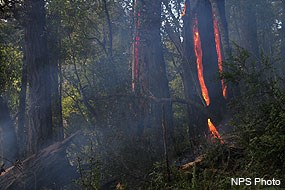
Douglas-fir trees that were ignited near Divide Meadow by a rare lighting strike in March 2009.
Wildfires are a vital part of the natural environment of coastal California. Fire has many beneficial impacts on our ecosystems, including recycling nutrients, allowing some species of plants and animals to grow and thrive, and creating and enhancing diversity across the landscape.
Fires were quite common at Point Reyes for thousands of years before 1850. While fires in this area were—and still are—seldom sparked by lightning, the Coast Miwok intentionally ignited fires to manage vegetation. The Coast Miwok set fires in meadows on a regular basis to increase food availability and seed harvests, and to control scrub encroachment into grasslands in order to make hunting easier.
Over the last century, wildfires at Point Reyes have become much less common due to active suppression of natural and human-generated fires. But with growing awareness of the importance of wildfire to maintaining healthy, natural ecosystems, the National Park Service has been revising how it manages fire. The Fire Management Program at Point Reyes National Seashore now works to protect neighboring communities from the risk of wildfires while also using prescribed fire as a tool for natural resource management.
Have an adventure AND contribute to community science at the same time? Learn how you can earn a limited-edition patch while helping to monitor the regrowth of various ecosystems in the wake of the 2020 Woodward Fire in Point Reyes National Seashore.
Locations:Bandelier National Monument, Bighorn Canyon National Recreation Area, Black Canyon Of The Gunnison National Park, Bryce Canyon National Park, Canyonlands National Park, Capitol Reef National Park, Capulin Volcano National Monument, Carlsbad Caverns National Park, Cedar Breaks National Monument, Chiricahua National Monument, City Of Rocks National Reserve, Crater Lake National Park, Craters Of The Moon National Monument & Preserve, Curecanti National Recreation Area, El Malpais National Monument, Florissant Fossil Beds National Monument, Gila Cliff Dwellings National Monument, Glacier National Park, Golden Gate National Recreation Area, Grand Canyon National Park, Grand Teton National Park, Great Basin National Park, Great Sand Dunes National Park & Preserve, Lake Roosevelt National Recreation Area, Lassen Volcanic National Park, Mesa Verde National Park, Mount Rainier National Park, North Cascades National Park, Olympic National Park, Oregon Caves National Monument & Preserve, Point Reyes National Seashore, Redwood National and State Parks, Saguaro National Park, San Juan Island National Historical Park, Sunset Crater Volcano National Monument, Valles Caldera National Preserve, Walnut Canyon National Monument, Whiskeytown National Recreation Area, Yellowstone National Park, Yosemite National Park, Zion National Parkmore »
Offices:Wildland Fire Program
Douglas fir is widely distributed throughout the western United States, as well as southern British Columbia and northern Mexico. Douglas fir is able to survive without fire, its abundantly-produced seeds are lightweight and winged, allowing the wind to carry them to new locations where seedlings can be established.
In October 1995, an illegal campfire in Point Reyes National Seashore ignited the largest wildfire to hit the area in sixty years. The Vision Fire, as it came to be known, scorched more than 12,000 acres, affecting not just the seashore’s flora and fauna, but also the private lands of nearby residents. Dozens of homes and other structures were destroyed. Memories of Vision have haunted Point Reyes ever since.
Join Science Communication Intern Jerimiah Oetting as he dives into how the Woodward Fire compares to its predecessor, what that recovery will look like in the coming months and years, and how certain vulnerable species might be impacted by wildfires in three new episodes of The Natural Laboratory podcast series.
This year’s fire season was historic in California. According to Cal Fire, over 4 million acres had burned as of mid-November. That's more than double the footprint that made 2018 the previous record holder. The Woodward fire in Point Reyes National Seashore, at 5,000 acres, was only a small component of that total. But it was driven by the same conditions that fuel the state’s largest fires: human-caused climate change and fire suppression.
Dense thickets of young Bishop pine were removed along Limantour Road in Point Reyes National Seashore. The trees were cleared and thinned for 30 feet on either side of the road under a cooperative agreement with a local conservation corps. The recent roadside thinning treatments extend a fuel break into the next section where the vegetation has transitioned to Bishop pine. Thinning will improve emergency access and egress during a wildfire along this major park corridor.
Locations:Cabrillo National Monument, Channel Islands National Park, Chiricahua National Monument, Coronado National Memorial, Fort Bowie National Historic Site, Golden Gate National Recreation Area, Grand Canyon National Park, Organ Pipe Cactus National Monument, Pinnacles National Park, Point Reyes National Seashore, Saguaro National Park, Santa Monica Mountains National Recreation Area, Sequoia & Kings Canyon National Parksmore »
Offices:Wildland Fire Program
Chaparral is a general term that applies to various types of brushland found in southern California and the southwestern U.S. This community contains the most flammable type of vegetation found in the United States.
In February 2012, an excavator mounted with a mastication drum treated part of Bayview Fire Road at Point Reyes National Seashore. All vegetation within 15-25 feet of the fire road was mulched. This technique accomplished in a few weeks what would have taken months for a 10-person crew to achieve, making it highly cost effective. The road is a critical evacuation route for hundreds of residents, and fuel reduction will enhance its use as a control line in fire suppression.
415-464-5100
This number will initially be answered by an automated attendant, from which one can opt to access a name directory, listen to recorded information about the park (e.g., directions to the park; visitor center hours of operation; fire danger information; wildlife updates; ranger-led programs; seasonal events; etc.), or speak with a ranger. Please note that if you are calling between 4:30 pm and 10 am, park staff may not be available to answer your call.