Last updated: October 5, 2020
Place
Smoking Place

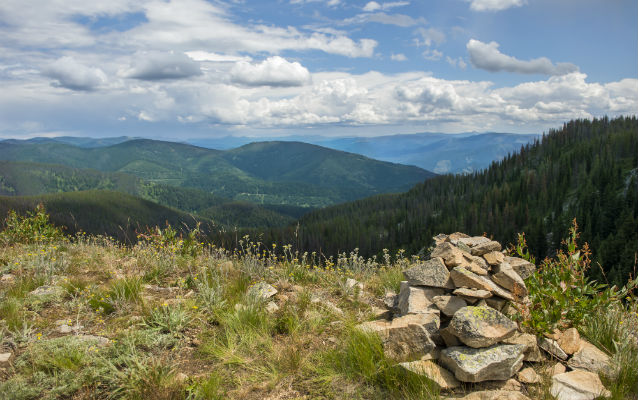
Photo by Tommy LaVergne, courtesy of Rice University.
Lewis and Clark NHT Visitor Centers and Museums
This map shows a range of features associated with the Lewis and Clark National Historic Trail, which commemorates the 1803-1806 Lewis and Clark Expedition. The trail spans a large portion of the North American continent, from the Ohio River in Pittsburgh, Pennsylvania, to the mouth of the Columbia River in Oregon and Washington. The trail is comprised of the historic route of the Lewis and Clark Expedition, an auto tour route, high potential historic sites (shown in black), visitor centers (shown in orange), and pivotal places (shown in green). These features can be selected on the map to reveal additional information. Also shown is a base map displaying state boundaries, cities, rivers, and highways. The map conveys how a significant area of the North American continent was traversed by the Lewis and Clark Expedition and indicates the many places where visitors can learn about their journey and experience the landscape through which they traveled.
On June 27, 1806, the expedition proceeded east on the rugged Lolo Trail. Clark wrote, “we halted by the request of the Guides a fiew minits on an ellevated point and Smoked a pipe on this eminance the nativs have raised a conic mound of Stons of 6 or 8 feet high and erected a pine pole of 15 feet long. from hence they informed us that when passing over with their families some of the men were usually Sent on foot by the fishery at the enterance of Colt Creek in order to take fish and again meet the party at the quawmash glade on the head of Kooskoske river. from this place we had an extencive view of these Stupendeous Mountains principally Covered with Snow like that on which we Stood; we were entirely Serounded by those mountains from which to one unacquainted with them it would have Seemed impossible ever to have escaped […] after haveing Smoked the pipe and Contemplating this Scene Sufficient to have dampened the Spirits of any except Such hardy travellers as we have become, we continued our march.”
Smoking Place is located within Clearwater National Forest, along Forest Road 500, also known as the Lolo Motorway. Constructed in the 1930s, the single lane dirt road roughly follows the historic route traversed by Lewis and Clark west of the Bitterroot Divide. The rock cairn originally described by Clark is no longer extant; a smaller cairn now marks the landscape. The site is a component of the Lolo Trail National Historic Landmark.
