Last updated: November 11, 2024
Place
Green River Overlook: Green River Overlook
J. Carver
Quick Facts
Location:
Island in the Sky
Significance:
Wayside Panel
Amenities
1 listed
Historical/Interpretive Information/Exhibits
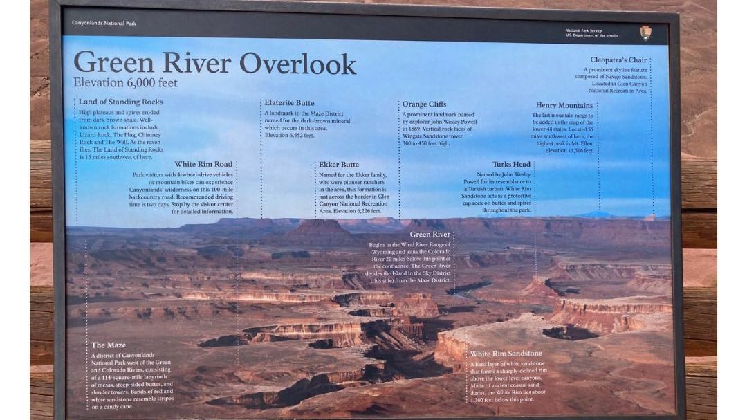
Elevation 6,000 feet
Left to Right: Land of Standing Rocks: High plateaus and spires eroded from dark brown shale. Well-known rock formations include Lizard Rock, The Plug, Chimney Rock and The Wall. As the raven flies, The Land of Standing Rocks is 15 miles southwest from here.
The Maze: A district of Canyonlands National Park west of the Green and Colorado Rivers, consisting of a 114-square-mile labyrinth of mesas, steep-sided buttes, and slender brown towers. Bands of red and white sandstone resemble stripes on a candy cane.
White Rim Road: Park visitors with 4-wheel-drive vehicles or mountain bikes can experience Canyonlands' wilderness on this 100-mile backcountry road. Recommended driving time is two days. Stop by the visitor center for detailed information.
Elaterite Butte: A landmark in the Maze District named for the dark-brown mineral which occurs in this area. Elevation 6,552 feet.
Ekker Butte: Named for the Ekker family, who were pioneer ranchers in the area, this formation is just across the border in Glen Canyon National Recreation Area. Elevation 6,226 feet.
Orange Cliffs: A prominent landmark named by explorer John Wesley Powell in 1869. Vertical rock faces of Wingate Sandstone tower 300 to 450 feet high.
Green River: Begins in the Wind River Range of Wyoming and joins the Colorado River 20 miles below this point at the Confluence. The Green River divides the Island in the Sky District (this side) from the Maze District.
White Rim Sandstone: A hard layer of white sandstone that forms a sharply-defined rim above the lower level canyons. Made of ancient coastal sand dunes, the White Rim lies about 1,300 feet below this point.
Turks Head: Named by John Wesley Powell for its resemblance to a Turkish turban. White Rim Sandstone acts as a protective cap rock on buttes and spires throughout the park.
Henry Mountains: The last mountain range to be added to the map of the lower 48 states. Located 55 miles southwest of here, the highest peak is Mt. Ellen, elevation 11,506 feet.
Cleopatra's Chair: A prominent skyline feature composed of Navajo Sandstone. Located in the Glen Canyon National Recreation Area.