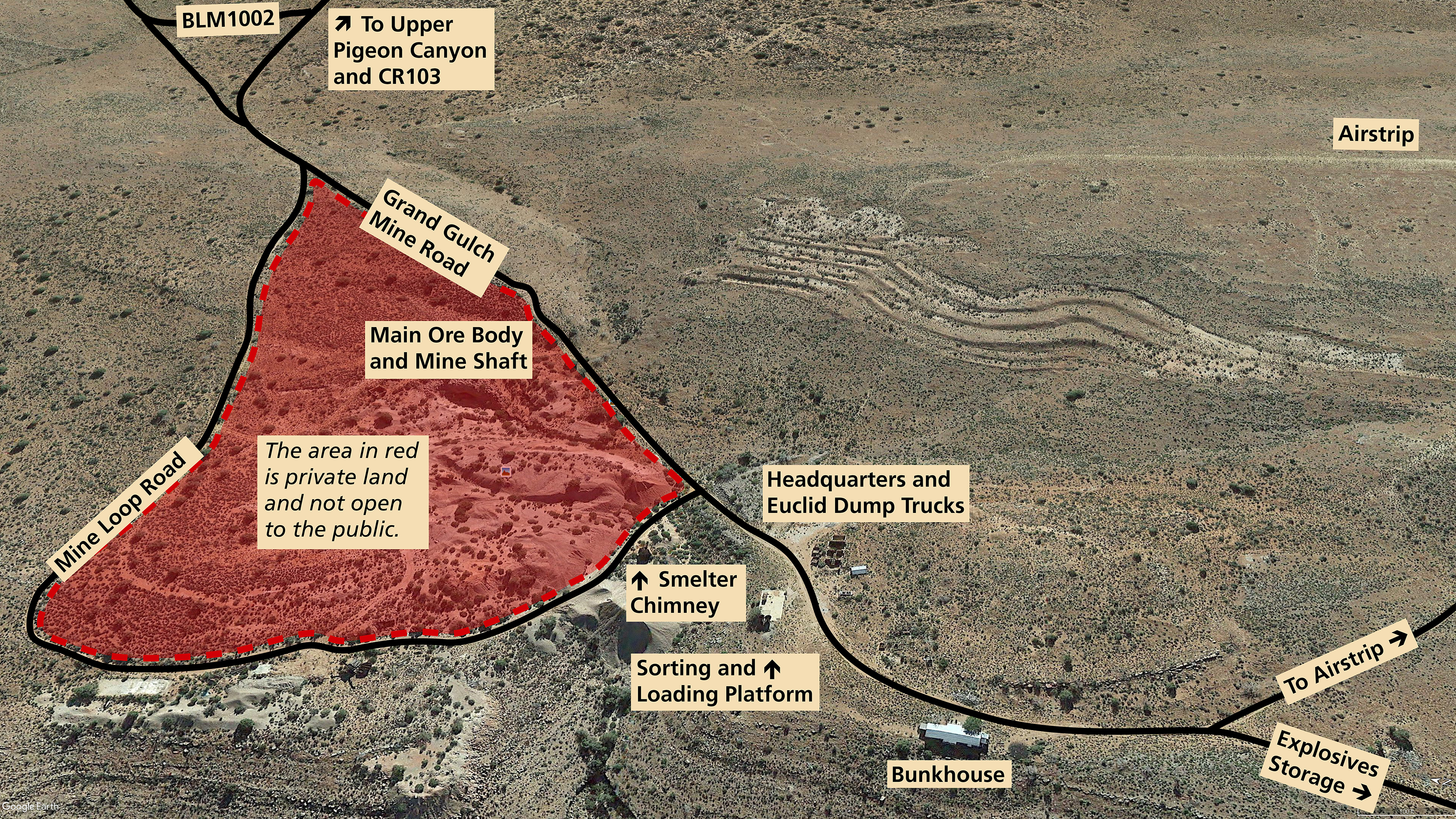
Grand Gulch Mine

Two abandoned dump trucks in front of a ruin of a brick mine building
Two abandoned Euclid mine trucks in front of the ruins of the Grand Gulch Mine Headquarters. These trucks were brought in during the short-lived uranium boom of the 1950s. No significant uranium deposits were found in the mine.

NPS

 
The green coating on this limestone rock is called malachite, a form of copper ore.
This is a piece of ore from the mine. The green color is a copper mineral called malachite. Less common are the blue pieces of azurite, a different copper ore that is also found in the tailings piles. Please remember collecting is not allowed so that others can discover these colorful stones.

NPS - J. Axel

From St. George the drive time to the Grand Gulch Mine is about 3 hours one way. Most of the year the mine is accessible. The two exceptions are after a winter snow when the road can be impassible until dry, and from July - September when flash floods in upper Pigeon Canyon can wash the road out creating high cut banks. Be sure to bring a shovel.

Watch the new 12 minute film about the history of the Grand Gulch Mine.

Why was there so much copper here? This was unlike most mines. Read more about the geology of the Grand Gulch Mine breccia pipe.

Safety:
While almost all of Parashant has no cell phone service, rangers have reported 1-2 bars of Verizon cell phone and data service at the Grand Gulch mine airstrip information kiosk. There is a view south through a canyon gap toward Meadview, AZ, where the cell tower is located. Planes still land here so be aware of low flying aircraft. A vault toilet is planned for installation at the aistrip in 2021.

As you explore the Grand Gulch Mine, avoid parking off the road. There is a lot of rusty metal hidden in the grass which can slice open a tire.
 
Image taken in 1917 showing several mine workers, a 100 foot long pile of rocks and several mine buildings
Image taken in 1917 of Grand Gulch mine operations during World War 1.

NPS

 
Vehicle Recommendations:
• High Clearance Trucks or SUVs (passenger cars, minivans, or RVs will not make it)
• Four Wheel Drive
• All-Terrain Tires

Directions
From Interstate 15, take Exit 2 east onto the Southern Parkway (Hwy 7) toward the airport. Take Exit 3 (River Road) and turn south. Set your vehicle trip odometer to 0 where the pavement ends at the state line.

BLM Road 1069
You have now crossed into Arizona and are on BLM Road 1069. The road is well maintained gravel. For the first 4 miles you will be on Arizona State Trust Land. At mile 4.4 you will pass the BLM Arizona Strip sign. You are now on BLM land. BLM1069 winds its way up to Quail Hill Pass. At mile 20.6 you will reach the BLM1004 junction in Wolf Hole Valley. Continue straight.

Mohave County Roads 5 and 103, BLM Road 1002
At the BLM1004 junction in Wolf Hole Valley, BLM1069 turns into CR5. Travel 18.5 miles south through the broad Main Street Valley to the turn onto CR103. Travel 25.2 miles on CR103 until you reach the right turn onto BLM1002. After a short distance BLM1002 drops into Upper Pigeon Canyon where high clearance and four wheel drive will be needed.

BLM1002 winds its way down 10.3 miles through the scenic canyon on a moderately rough road. Continue on BLM1002 past the BLM1012 junction (notice the large cattle watering tank here). It is another 4 miles to the Grand Gulch Mine (map). The main road continues to two large dump trucks (photo above) and several ruins. This is a good place to park. You are free to explore the site but remember to leave historic items for others to discover. Collecting is not allowed.

Extreme 4x4 Roads in the Grand Gulch Mine Area

BLM1012 heads south from BLM1002 past two other breccia pipe copper mines. It then climbs up to Snap Canyon. This road is only for high clearance short wheelbase 4x4s and UTVs.
 
Two jeeps in a rocky canyon driving across boulders
This is NOT the main road to the Grand Gulch Mine. For those with a specialized 4x4 with high clearance and tough tires, the original mine road through Grand Gulch Canyon (BLM1050) is a great adventure. Most people will take the main route on BLM1002 from County Road 103 to the mine.

NPS - J. Axel

BLM1050 is the old ore road dugway from the mine down to the Pakoon Basin through Grand Gulch Canyon. After some repair work was done in 2020 after a washout, this road is once again passable for UTVs and properly equipped high-clearance short wheelbase 4x4s. Pickup trucks and stock SUVs will not make it on this road. This road is steep and crosses several sections of boulders as seen in the photo. Vehicle damage is possible and tow bills are very expensive from this location. Technical 4x4 experience is needed as well as a second person to spot you as you climb through the boulder sections.
 
Stars and a shooting star above the historic bunkhouse ruin
The dark night skies of the Parashant are stunning from the Grand Gulch mine. There are no nearby sources of artificial light other than a faint glow on the horizon from far away cities. (Photo is of the miner's bunkhouse)

NPS - Todd Miller

 
small backcountry plane on Grand Gulch Mine airstrip
A bush plane in the grass at the Grand Gulch Mine's unpaved airstrip. Upper Grand Wash Cliffs in the background including Hudson Point (farthest point in the upper left)

J. Axel - NPS

Last updated: December 16, 2020

Park footer

Contact Info

Mailing Address:

Public Lands Visitor Center
345 East Riverside Drive

Saint George, UT 84790

Phone:

(435) 688-3200
This federal interagency office is staffed by employees from the National Park Service, Bureau of Land Management, U.S National Forest Service, and by dedicated volunteers from the local community. Phones are answered Monday through Friday, 8 a.m. to 4:30 p.m. The visitor center is closed on Saturdays, Sundays, and all federal holidays.

Contact Us