|
I have learned a lot from trees;

Emil Christofferson Special Concerns:
Backcountry Camping: A backcountry permit is required for all overnight stays. Permits are limited. There are numerous campsites along this trail, at most five miles apart. Some of the camps, such as Two Mile or Thunder Basin are small and do not hold larger groups. Designated stock camps are located at McAllister, Junction, and Thunder Basin, as well as at Five Mile along the Park Creek Trail. Access from SR 20: Follow State Route 20 to mile 130, Diablo Lake. Enter the south side of Colonial Creek Campground and park in the large lot above the boat ramp. Stock parties should access this trail via the trailhead that lies uphill from the parking lot behind the trailer dump station. This is the preferred trailhead for horses. Hikers and backpackers should walk the length of the campground, following the signs to the amphitheater, where the main trail begins. Access via Stehekin: From Stehekin Landing, take the shuttle bus to High Bridge and follow the Old Wagon and Upper Stehekin Valley (old road) trails 7.5 miles (12 km) to the Park Creek Trail.

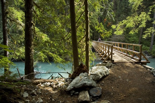
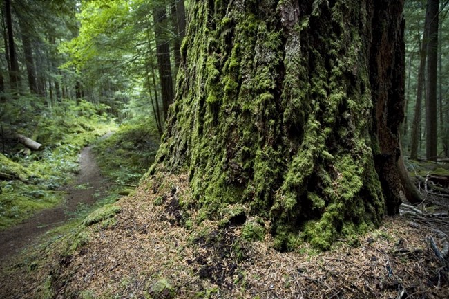
Emil Christofferson Detailed Trail Description The first half mile (.8 km) follows Thunder Arm of Diablo Lake. Note the turquoise color of the lake and stream. This is because Thunder Creek carries a heavy load of “rock flour,” ground by the many glaciers of its headwaters. This trail was opened by prospectors and trappers. Mining developers and the US Forest Service made major improvements in the early 1900’s. Look for old blazes, and a few cut stumps along the way. The trail winds through some exceptionally large old cedar and fir trees, with periodic views of the creek. Woodland flowers abound in season. This is the home of many birds, including owls, woodpeckers, and osprey near the creek. Look for deer and other animal tracks in the sandy soil and mud. At around 1.5 miles (2.4 km) the trail crosses Thunder Creek on a large wooden bridge. Thunder Camp lies just on the other side, and is a wonderful destination for families or for a first backpack. Many day hikers also enjoy bird watching from the bridge or exploring the nearby gravel bars. A quarter mile past the bridge and camp, the Fourth of July Trail junction is on the left. Following this trail up 3.2 miles (5.1 km) of switchbacks to Fourth of July Pass provides beautiful mountain views, particularly from the backcountry camp. Neve Camp is a quarter mile beyond this junction, and is another lovely forested camp set well off the trail alongside the thunderous waters of the creek--which looks and sounds more like a small river at this point. Along Thunder Creek Trail, the first open view is from a 1970 burn at about 4.5 miles (7.2 km). Here an emerging forest of young Douglas-fir and a profusion of seed bearing herbs and shrubs attract birds, rodents and their predators. Across the valley, note a newer burn from lightning strikes in 1990. Rock cliffs and McAllister Glacier provide natural fire breaks and a splendid backdrop for this evolving forest scene. The next backcountry camps, McAllister hiker, stock and group, are located at mile 6.7 (10.8 km) and are a popular overnight destination. The bridge to the old McAllister camps washed out in a flood but a new camp was built in 2021, along with a trail re-route away from the eroding banks of Thunder Creek. Access to McAllister hiker, stock and group camp are all found along this new trail. Smaller Tricouni Camp lies 1.3 miles (2.1 km) beyond McAllister, in a more open salal forest, just after crossing Fisher Creek on a bridge. From Tricouni, the trail begins its first real climb: a relentless 2.2 miles (3.5 km) gains over 1000 feet (305 m) to reach Junction Camps (hiker and stock) and a major trail junction. From the high ridge of the hiker camp, enjoy an expansive view of Boston Glacier and Tricouni Peak. From here, one may either take the Fisher Creek Trail 14.8 miles (23.8 km) over Easy Pass to SR 20, or continue on the Thunder Creek Trail to Park Creek Pass. Both ways lead to grand trail experiences. Just past Junction, a one mile (1.6 km) side trail drops precipitously to the historic Meadow Cabins, associated with early mining activities, and located at the edge of a large swamp. The main trail drops steadily for 2.6 miles (4.2 km) into the valley through stands of old fire-scarred Douglas-fir and even-aged lodgepole pine. Then, a steep one mile (1.6 km) climb through silver fir forests brings the hiker to Skagit Queen Camp. Just beyond the camp are relics of early 1900s mining development. The water-powered generator ran an air compressor which supplied piped compressed air to drill rigs up Skagit Queen Creek. Look for signs of mining activity further along the trail. Much effort and money was expended before developers abandoned this remote and rugged land. Above Skagit Queen, the trail rises steeply for a mile (1.6 km) into the mouth of Thunder Basin, a hanging glacial valley. More hiking through avalanche paths and stands of silver fir leads to the fringes of the subalpine zone where Thunder Basin Stock Camp is located, 2.9 miles (4.7 km) beyond Skagit Queen. Just before reaching the stock camp, ford Thunder Creek, now a much smaller but still strong creek. Do not cross during periods of high water. The hiker camp is located another mile (1.6 km) past the stock camp, in a subalpine meadow of heather and subalpine fir. Bring a portable food canister if you are camping here, as tall trees are scare and black bears common. Park Creek Pass looms above the camp, and views abound. 
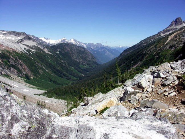
Michael Kirshenbaum Beyond the Thunder Basin hiker camp, the trail continues its climb over another 1.5 miles (4.2 km) through steep meadows and snowfields to Park Creek Pass (6,100 ft/1860 m), a notch between Mt. Logan to the northeast and Mt. Buckner to the southwest with views in both directions into the great valleys below. An ice axe is often needed for travel over the steep snow of this pass through mid-summer. The subalpine meadows surrounding the pass have been eroded from past uses. There is no camping at the pass or in the surrounding fragile meadows to allow these plants to recover and survive. Camping in the designated sites below the pass helps keep the meadows healthy for all to enjoy. From Park Creek Pass, the Park Creek Trail descends quickly through heather and wildflower meadows into a hanging valley and then down again into willowy meadows just before reach Five Mile Camp. Look back for final views of Buckner and its hanging glaciers. The trail heads into the forest and shortly arrives at Five Mile Camp, a creek-side stock camp. Contouring down the forested slopes of Park Creek Valley, the trail passes one more camp, small Two Mile, just after crossing Park Creek on an improved log crossing. The floods of 2003 re-arranged this camp significantly, leaving only the one small site. The trail drops steeply once more, through a forest that now includes big leaf and vine maple, before leveling out and intersecting the Upper Stehekin Valley Trail (the old Stehekin Valley Road, which was washed out by floods in 1995, 2003, and 2006 before the upper stretch was finally closed). Park Creek Camp sits at this junction. From here, parties can head west following the Stehekin River up and over Cascade Pass, or turn east to head toward Stehekin or Bridge Creek. High Bridge, which is the turn-around point for the Stehekin Valley shuttle bus, is a 7.5 mile (12 km), mostly flat walk. 
NPS / Rosemary Seifried 
|
Last updated: September 3, 2021
