
Danny Lee Visiting New River Gorge National Park and Preserve by vehicle is an up-and-down experience. While some roads travel along the rim and some along the river, others wind up-and-down between the two. Vistas along the rim offer views of the sandstone walls of the gorge and the river below. At the bottom of the gorge along the river there is relatively little flat land, but it provides an opportunity to view the New River and its plants and animals.
Life is diverse and abundant within the park. Vultures soar over the gorge, salamanders hide in the damp forest, great blue herons stand at the river's edge, and deer browse the slopes. Spring with its wildflowers and fall with its tapestry of colored leaves are special times for a gorge visit. 
NPS photo New River Gorge Scenic DriveEncircling the heart of New River Gorge National Park and Preserve, the drive is an estimated three-hour trip. The 83-mile route includes interstates, divided highways, and two-lane roads. Although much of this drive is outside of the park, it provides an opportunity to experience the park—its gorge and its river. Along the way are broad vistas as well as small glimpses of both the past and the present. Two park visitor centers, Canyon Rim and Sandstone, supplement the tour with interpretation of the natural and historic resources of the park. 
NPS Scenic Drive Stops
NPS/S. Merlau Canyon Rim Visitor CenterApproximate distance: 0.1 miles from US 19Canyon Rim Visitor Center is located on the rim of the gorge near the New river gorge bridge. Open daily, the center offers interpretive exhibits, a park film, bookstore, and photographic views of the New River Gorge. Fully accessible walkways lead to overlooks, which provide views of the river, its gorge, and the bridge that has spanned it since 1977. 
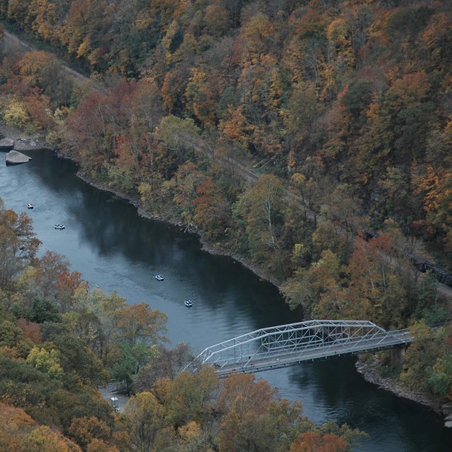
NPS/Louise McLaughlin Fayette Station RoadApproximate distance: 0.1 miles from US 19The 7.5 mile drive begins from the Canyon Rim Visitor Center. Fayette Station Road is a mostly one-lane road that winds down under the New River Gorge Bridge and is a spur of the National Coal Heritage Trail. Roadside exhibits describe the history of mining, transportation, and life in the gorge. A parking area affords views of Fayette Station Rapid, and often of rafters and kayakers ending their whitewater trips. 
NPS Kaymoor Mine AreaApproximate distance: 3.9 miles from US 19 on Gatewood RoadOne of the largest coal mines of the gorge, the Kaymoor Mine prospered for sixty years, closing in 1962. From a parking area at the rim of the gorge, the Kaymoor Miners Trail descends steeply ½ miles to the abandoned mine. Reaching the remains of the tipple at river level requires an 821 step descent along the haulage and then a strenuous return climb. 
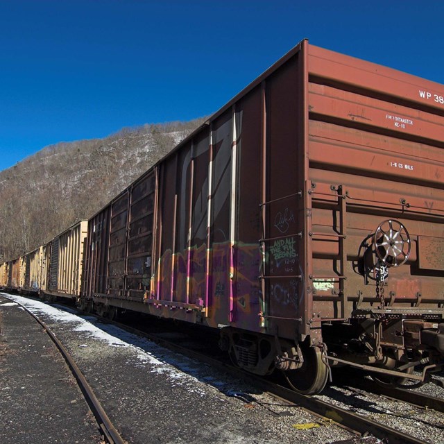
NPS Thurmond Historic DistrictApproximate Distance: 7 miles from US 19 at Glen JeanFollowing Dunloup Creek for seven miles, narrow Route 25 leads to the restored Thurmond Depot on the far side of the river. Open daily in the summer, Depot exhibits interpret the town and railroad operations. A short walk to “downtown” Thurmond offers a look at this once-thriving community. Picnicking, fishing, and hiking trails are nearby. CAUTION: The railroad line is active. Keep off the tracks.
NPS Quinnimont ConnectorApproximate Distance: 24.2 Miles from Glen Jean to DaneseRoute 61 leads to a turn onto Route 41, which follows Piney Creek to descend into the gorge. McCreery offers a close-up view of the New River. After crossing the bridge, note the Stretcher’s Neck railroad tunnel, the train depot, and then search for the Beury Mounument behind the old post office in Quinnimont before following Laurel Creek out of the gorge to the town of Danese. 
NPS Glade Creek AreaApproximate Distance: 6.3 miles from Route 41Just before the bridge that crosses the New River is a gravel road that leads to Glade Creek. Known as the Royal Road, it passes the scattered foundations of the town of Royal, ¼ miles down the road. One mile down is Grandview Sandbar with picnicking, camping, and river access. Five miles further down is Glade Creek with a small campground, river access, and trailhead. 
NPS GrandviewApproximate Distance: 5 miles from I-64 at exit 129The overlooks at Grandview, the highest in the park, offer broad views of the land cut by the New River and its many tributaries. Rhododendron frame the view in mid-May and fall color adds to the panorama in October. Grandview offers trails, picnicking, a summer-season visitor center, and outdoor summer evening performances by Theater West Virginia. 
NPS Sandstone Visitor CenterApproximate distance: 0.1 miles from I-64 at exit 139A large inlaid floor map, a brief video, a bookstore, and a native plant landscape are features of Sandstone Visitor Center, which is open daily. Interactive exhibits and touch-screen computers interpret the rich resources of the New River watershed and describe ways that individuals can lessen their impacts on the environment. 
NPS Sandstone FallsApproximate distance: 22.5 miles from I-64 at exit 139Route 20 climbs Chestnut Mountain to an overlook of Sandstone Falls before descending into Hinton. After crossing the New River, narrow Route 26, River Road, follows the river for 10 miles. A stop at Brooks Falls offers views of river ledge and a river “hole”. At Sandstone Falls, the largest waterfall on the New River, a fully-accessible boardwalk leads to an island and its observation decks. 
NPS Babcock State ParkApproximate Distance: 0.5 miles from Route 41Babcock State Park, one of the oldest parks in West Virginia, is located within the boundaries of New River Gorge National Park and Preserve. A feature of the 4,000 acre park is a widely-photographed grist mill. Within the park are log cabim accommodations, hiking trails, a stable, a lake for fishing and boating, and campsites. 
NPS Endless WallApproximate distance: 1.2 miles from US 19, just north of Canyon Rim Visitor CenterFrom the Fern Creek parking area, the 2.4 miles Endless Wall Trail winds through the hemlock forests and rhododendron thickets. The long sandstone outcrop is favored by rock climbers. Rewards are the views from vantage points above Endless Wall at Diamond Point. Scenic Drives in and around the Park
|

Last updated: July 31, 2024