Filter Your Results
- Golden Gate National Recreation Area (66)
- Yellowstone National Park (61)
- Lewis & Clark National Historic Trail (45)
- Point Reyes National Seashore (35)
- Lake Roosevelt National Recreation Area (33)
- Chesapeake Bay (29)
- Everglades National Park (29)
- Grand Canyon National Park (29)
- Cape Hatteras National Seashore (27)
- Show More ...
- Inventory and Monitoring Division (40)
- Natural Resource Stewardship and Science Directorate (29)
- Geologic Resources Division (25)
- Water Resources Division (24)
- Sonoran Desert Inventory & Monitoring Network (22)
- Southern Plains Inventory & Monitoring Network (20)
- Northern Colorado Plateau Inventory & Monitoring Network (14)
- Chihuahuan Desert Inventory & Monitoring Network (10)
- Natural Resource Condition Assessment Program (10)
- Show More ...
Showing 1,483 results for waterways ...
Capitol Reef National Park
Scenic Drive Stop 11
- Type: Place

The Capitol Gorge trail features natural pools of water and markings from early pioneers and travelers.
Capitol Reef National Park
Scenic Drive Stop 7
- Type: Place

Summer monsoon season brings heavy rain and flash flooding to Capitol Reef. The torrents of water can be spectacularly beautiful, but also deadly.
- Type: Place

Chesapeake Bay
Menokin
- Type: Place

Explore Menokin, a National Historic Landmark where history, architecture, and conservation meet. See the 1769 home of Francis Lightfoot Lee, witness innovative preservation in action, and walk trails through a protected Chesapeake Bay watershed landscape. Engage with exhibits, hands-on activities, and the powerful stories of those who shaped this place. Paddle Cat Point Creek, connect with nature, and uncover the past in a truly unique setting.
Chesapeake Bay
St. Clement’s Island Museum
- Type: Place

Discover the St Clement’s Island Museum where Maryland's founding story comes to life. Explore exhibits that highlight the rich history of the Piscataway People and early settlers. Stand on the historic island where the first English settlers landed in 1634, accessible by water taxi. Experience the beauty of the Potomac River and immerse yourself in the culture that shaped the Chesapeake Bay. Don’t miss the chance to learn and explore this unique site in St. Mary’s County.
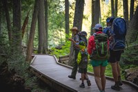
Grand Teton National Park
Jenny Lake Pathway Hub
- Type: Place

The Jenny Lake Pathway Hub is the most northern point of the multi-use pathway. Read our informational sign about biking and use the bike rack to store your bike while you explore the Jenny Lake area.
- Type: Place

Just a short drive from many Mid-Atlantic cities, the Northern Neck National Heritage Area offers a journey back in time. Whether for a day, weekend, or week, you’ll find endless opportunities to explore history, enjoy coastal charm, and experience natural beauty. From historic sites to scenic byways, there’s always something new to discover in this unique corner of Virginia.
Bryce Canyon National Park
RV Dump Station
- Type: Place

This RV Dump Station is typically open spring - fall, closing for the season when overnight temperatures fall below freezing. The dump station is located at the south end of North Campground and can be used by any visitor for a $5 use fee. No use fee applies for those with a campground reservation in the park. Potable water is available.
- Type: Place
The Halfway Creek and Loop Trails are accessible from the Gulf Coast Visitor Center in Everglades City or from the Big Cypress Welcome Center on Sea Grape Drive off of US 41. The Creek is 7.3 miles long from the Big Cypress Welcome Center to the Gulf Coast Visitor Center. The upper loop is an additional 3.7 miles. From the Gulf Coast Visitor Center, the Halfway Creek-Left Hand Turner-Turner River loop is 11 miles. Allow 4-8 hours for these trails.
Grand Canyon National Park
Bright Angel Trail
- Type: Place

Bright Angel Trail lets hikers walk in the footsteps of the canyon's Indigenous Peoples, miners, and early tourists, as they descend into the canyon's depths. Offering big views, morning and afternoon shade, resthouses, vault toilets, and water stations during the summer. The water is OFF at 1.5- and 3-mile resthouses. Portions of Bright Angel Trail are closed for waterline construction, Visit the link for a list of trail closures.
Glacier National Park
Trail of the Cedars
- Type: Place
Trail of the Cedars is a peaceful boardwalk nature trail along Avalanche Creek. Follow the boardwalk through old growth cedars, listen to the American dippers, see the powerful force of water carving the Avalanche Gorge.
Manhattan Project National Historical Park
Oak Ridge Wayside: Solway Bridge
- Type: Place
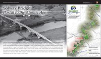
A wayside exhibit in Oak Ridge, Tennessee describing the Solway Bridge, a main artery from Knoxville to the Secret City during the Manhattan Project.
- Type: Article

For the first time at Big Cypress National Preserve, researchers used tree rings (growth rings) to study tree ages and which environmental/climate factors influence tree growth. One finding was that standing water levels—in this landscape shaped by water—are key. Researchers were also reminded that “you can’t always judge a book by its cover,” as some of the smallest trees measured were also the oldest.
War In The Pacific National Historical Park
Fonte Plateau Unit
- Type: Place

Fonte Plateau Unit is the site of the final battle in Phase 1 of the Battle of Guam. While American forces secured the beachheads at Assan and Hågat by July 24, 1944, to secure and link the two beachheads, they needed to capture the well-fortified hills and mountains overlooking the water. This task was accomplished on July 29, 1944, when the 9th Marines captured Fonte Plateau. Today, the main feature at the Fonte Plateau Unit is the Imperial Japanese communications center.
Natural Resource Stewardship and Science Directorate
Teaming Up for Science
- Type: Article

A new partnership began in October 2021 and supports science and stewardship activities that benefit both parks and their local communities. Over the next five years parks and their communities will collaborate to identify and address their scientific priorities. Projects in the first year will focus on water quality, marine biodiversity, and preservation of night skies.
Arches National Park
How Dry Will Parks Get? Water Deficit Tells Us
- Type: Article

Dryness has an outsized impact on nature in parks, but temperature and precipitation are poor indicators.
Acadia National Park
A New Way to Gauge Risk of Toxic Blooms in a National Park
- Type: Article

Harmful algal blooms endanger drinking water sources and aquatic life but are notoriously hard to study and manage. We created a “scorecard” to assess the likelihood of toxic blooms. It can help water managers focus on the most effective actions.
- Type: Article

The Inventory and Monitoring Division funded a project to study wetland habitats in Dinosaur National Monument, exploring their locations, conditions, and ecological roles. Data from this project will inform park management decisions and future updates to water rights.
- Type: Place

Turner River Canoe Trail information
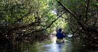
Everglades National Park
Everglades Wilderness Waterway
- Type: Place

The wilderness of Everglades National Park is very different from other places you may have boated, paddled, or camped. It can be confusing and difficult to navigate as the mazes of mangrove–lined creeks and bays all begin to look the same. With proper planning, you can avoid the frustration and hours wasted from getting lost. The 99-mile Wilderness Waterway attracts interest because it connects Flamingo and Ev-erglades City. Most paddlers allow at least eight days to complet