Filter Your Results
- Grand Canyon National Park (127)
- Lewis & Clark National Historic Trail (84)
- Golden Gate National Recreation Area (78)
- Santa Fe National Historic Trail (74)
- Katmai National Park & Preserve (59)
- Yellowstone National Park (56)
- Mount Rainier National Park (54)
- Petrified Forest National Park (54)
- Lake Clark National Park & Preserve (53)
- Show More ...
- Inventory and Monitoring Division (34)
- Geologic Resources Division (31)
- National Register of Historic Places Program (23)
- Archeology Program (21)
- Natural Resource Stewardship and Science Directorate (21)
- Sonoran Desert Inventory & Monitoring Network (21)
- Wildland Fire Program (21)
- National Center for Preservation Technology and Training (19)
- Southwest Alaska Inventory & Monitoring Network (16)
- Show More ...
Showing 2,770 results for southwest ...
Grand Canyon National Park
Yavapai Lodge
- Type: Place
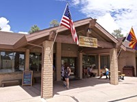
Located at Market Plaza, the South Rim's business center, the main lodge has a cafeteria style restaurant, coffee shop/cafe, gift shop and an outdoor patio tavern with a food menu. Pet friendly rooms are available. it's a short walk across the parking lot to Canyon Village Market (General Store and Deli), and the U.S. Post Office. From the lodge, it averages around a one mile (1.6 km) walk, along paved footpaths, to the edge of Grand Canyon.
Federal Hall National Memorial
Castle Clinton National Memorial
- Type: Place

Grand Canyon National Park
Backcountry Information Center
- Type: Place

The Backcountry Info Center is open daily from 8 am–noon; and 1 pm–5 pm, and provides information, permits, and trip planning assistance about day and overnight hikes into the canyon. The building is located in the village by Parking Lot D, and across the railroad tracks from Maswik Lodge. Park in Lot D, then take the free, early morning Hikers' Express bus from Backcountry Info Center to South Kaibab Trailhead.
Hawaiʻi Volcanoes National Park
Eruption Viewing near Keanakākoʻi Overlook
- Type: Place

Eruption viewing from the overlooks near Keanakākoʻi offers close-up views but requires planning. Parking is extremely limited between 5 p.m. and 9 p.m., so it's best to visit outside these hours. Have a Plan B if parking is full. The site requires a 2-mile round-trip hike (about 1 hour) from Devastation parking area. Additional parking at Puʻupuaʻi Overlook an additional 0.5 miles.
Acadia National Park
Acadia Mountain Trailhead
- Type: Place
This is the trailhead for Acadia Mountain, a 681 ft mountain located on the west side of Mount Desert Island. The trailhead is on Maine Route 102, about 3 miles south of Somesville and just after Ikes Point Boat Launch.
Acadia National Park
Flying Mountain Trailhead
- Type: Place

The Flying Mountain Trailhead is located north of Southwest Harbor, ME off State Route 102 via Fernald Point Road. It directly serves Flying Mountain and Valley Cove Trails with connections to Valley Peak Trail and Saint Sauveur Mountain Trail.
Glen Canyon National Recreation Area
Beehives Trailhead
- Type: Place

Trailhead for the Beehives trail, near the south entrance to Wahweap.
Fort Vancouver National Historic Site
Series: Ten Years at Vancouver Barracks
- Type: Article

Since 2012, the National Park Service has cared for and invested in the historic East and South Vancouver Barracks, providing new opportunities for reuse and community engagement.
Mount Rainier National Park
Paradise Inn
- Type: Place

If you enjoy historic architecture, a good meal or place to relax than the Paradise Inn is the place for you! Built in 1917, the Paradise Inn is open generally from May through September and features a large dining room and gift shop.
Grand Canyon National Park
South Kaibab Trail
- Type: Place

This well-maintained dirt trail offering wonderful expansive views. This is a great trail for short day hiking trips into the canyon of half a day or less. During winter months foot traction and hiking poles are advised when trail surfaces are icy. There is no public parking at the South Kaibab Trailhead. Please park at the Visitor Center, then take the Kaibab (Orange) Route shuttle bus to the trailhead. It is a 9-minute ride from the Visitor Center to the Trailhead.
- Type: Article

Fort Necessity National Battlefield park staff aimed to find out if Appalachian cottontail inhabited the park, so they collaborated with the Inventory and Monitoring Division to survey for their scat.
Fort Vancouver National Historic Site
Post to Park Transfer
- Type: Article

In 2012, the US Army transferred the east and south portions of Vancouver Barracks to the National Park Service.
Fort Vancouver National Historic Site
Developing the Master Plan
- Type: Article

The Post-to-Park transfer of the East and South Barracks to the National Park Service didn’t take place overnight – planning began over a decade earlier with thorough public involvement and community input. In 2012, Fort Vancouver National Historic Site released its Draft Master Plan for the site, with the goal of establishing a vision for public use and providing guidance for park managers for the next 20 years.
Santa Monica Mountains National Recreation Area
Paramount Ranch
- Type: Place
The diversity of the landscape made the Santa Monica Mountains an ideal backdrop for the film industry. Paramount Ranch’s variety of scenic qualities, landscapes, plant communities, and natural fea-tures offered a myriad of scenery available to represent outdoor landscapes nearly anywhere in the world
Lewis & Clark National Historic Trail
Mead Museum
- Type: Place

The Mead Cultural Education Center, located in Yankton, South Dakota, was constructed in 1909 by Dr. Leonard C. Mead. Originally serving as part of the women’s ward for the Dakota Hospital for the Insane, the building was in use until the 1980s. Today, however, it houses the Dakota Territorial Museum and is upkept by the Yankton County Historical Society.
Little Rock Central High School National Historic Site
Little Rock Central High School
- Type: Place
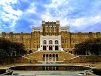
Little Rock Central High School, a functioning 9th - 12th grade facility, is a combined Collegiate Gothic and Art Deco style building that covers much of two city blocks and contains over 150,000 square feet. The school is closed to the public.
Manhattan Project National Historical Park
Manhattan Project Leaders: Henry L. Stimson
- Type: Person

Secretary of War during the Manhattan Project, Henry L. Stimson was General Leslie Groves’ immediate supervisor, authorized project sites, and made sure the project was given anything needed to be successful. President Harry Truman once said of Stimson, “I felt how fortunate the country was to have so able and so wise a man in its service.”
Grand Canyon National Park
Tusayan Pueblo Site and Self-guiding Trail
- Type: Place

The pueblo site and self-guiding trail are open Thursday through Friday, from 9 am to 4 pm. Located 3 miles (4.8km) west of Desert View Watchtower, the site is a small Ancestral Puebloan village showing the outlines of rooms and a round kiva. Visitors can walk a relatively flat 0.1 mile (200 m) self-guiding trail around the site. Visit the Native American Artisan Market with authentic and beautiful arts and crafts for sale. The adjacent museum is CLOSED until further notice.
- Type: Place

Located just off of 3-Trails Crossing Memorial Highway in the heart of the historic 3-Trails Corridor, Trailside Center provides resources for trail and civil war aficionados, historians, and the Kansas City community. Few visitors realize that the communities that established in this area in the early 1830s were situated at the western edge of the United States until Kansas Territory was established in 1854.
War In The Pacific National Historical Park
Assan/Asan Beach
- Type: Place
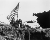
During the Japanese occupation of Guam, CHamoru were forced to build defenses on the beach, including the pillboxes and bunkers that can still be seen today, in preparation for the American invasion. That invasion came on July 21, 1944, W Day for Guam. While a simultaneous attack took place five miles south at Hågat, the Third Marine Division landed on the 2,500-yard Assan Beach, marking the start of the Battle of Guam.