Filter Your Results
- Yellowstone National Park (163)
- Boston National Historical Park (111)
- Rock Creek Park (100)
- Golden Gate National Recreation Area (96)
- Lewis & Clark National Historic Trail (95)
- Manhattan Project National Historical Park (84)
- Sleeping Bear Dunes National Lakeshore (80)
- Homestead National Historical Park (79)
- Grand Canyon National Park (77)
- Show More ...
- National Register of Historic Places Program (30)
- National Historic Landmarks Program (25)
- Northeast Coastal and Barrier Inventory & Monitoring Network (23)
- National Center for Preservation Technology and Training (18)
- Geologic Resources Division (16)
- National Heritage Areas Program (15)
- San Francisco Bay Area Inventory & Monitoring Network (10)
- American Battlefield Protection Program (6)
- Harpers Ferry Center (6)
- Show More ...
Showing 4,368 results for four-wheel drive ...
Little Rock Central High School National Historic Site
Little Rock Central High School
- Type: Place

Little Rock Central High School, a functioning 9th - 12th grade facility, is a combined Collegiate Gothic and Art Deco style building that covers much of two city blocks and contains over 150,000 square feet. The school is closed to the public.
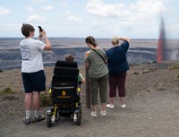
Hawaiʻi Volcanoes National Park
Eruption Viewing from Wahinekapu
- Type: Place

Experience the heat from nearby steam vents as you take in the breathtaking views of the eruption, with unobstructed, panoramic views of the entire cinder cone. Located on Crater Rim Drive West, 1 mile (4 minutes) from entrance station. A popular, but congested spot due to being the first overlook you encounter upon entering the park.
Grand Canyon National Park
Tusayan Pueblo Site and Self-guiding Trail
- Type: Place

The pueblo site and self-guiding trail are open Thursday through Friday, from 9 am to 4 pm. Located 3 miles (4.8km) west of Desert View Watchtower, the site is a small Ancestral Puebloan village showing the outlines of rooms and a round kiva. Visitors can walk a relatively flat 0.1 mile (200 m) self-guiding trail around the site. Visit the Native American Artisan Market with authentic and beautiful arts and crafts for sale. The adjacent museum is CLOSED until further notice.
Hawaiʻi Volcanoes National Park
Eruption Viewing from Uēkahuna
- Type: Place
The overlook at Uēkahuna offers great views into Halemaʻumaʻu crater and surrounding areas from the summit of Kīlauea volcano. Located at the end of Crater Rim Drive West, a 2.8 mile (7 minute) drive from the entrance station. Family-friendly location with ranger's on-site for information. More available parking compared to other locations.
Hawaiʻi Volcanoes National Park
Eruption Viewing from Kūpinaʻi Pali
- Type: Place

Escape the crowds and experience the eruption in solitude. This vantage point offers stunning wide-angle views of the caldera, being the furthest overlook from the eruption. Located at the end of Crater Rim Drive West, a 0.3 miles (2 minute) drive from the entrance station. Parking available near the closed Kīlauea Visitor Center. Hike 0.5 miles (20 minutes) towards Volcano House hotel and southeast on Crater Rim Trail.
Hawaiʻi Volcanoes National Park
Eruption Viewing from Kīlauea Overlook (Kapalikapuokamohoaliʻi)
- Type: Place

Kīlauea Overlook offers unobstructed views of the bottom of the Halemaʻumaʻu crater during an eruption. Located 2.5 miles (7 minutes) from the entrance station. Family-friendly location with great views. A short 0.4 miles walk from the overlook at Uēkahuna.
Lewis & Clark National Historic Trail
Mead Museum
- Type: Place

The Mead Cultural Education Center, located in Yankton, South Dakota, was constructed in 1909 by Dr. Leonard C. Mead. Originally serving as part of the women’s ward for the Dakota Hospital for the Insane, the building was in use until the 1980s. Today, however, it houses the Dakota Territorial Museum and is upkept by the Yankton County Historical Society.
Nicodemus National Historic Site
St. Francis Hotel
- Type: Place

The St. Francis Hotel has lived many lives: first as a place of business operated by early settlers Zachary and Jenny Fletcher, then as private residence and restaurant of the Switzer family. The original two-story limestone structure was built in 1881 and was a successful hotel in Nicodemus. The Switzer family bought the building in 1921 and built several additions while they lived there.
War In The Pacific National Historical Park
Assan/Asan Beach
- Type: Place

During the Japanese occupation of Guam, CHamoru were forced to build defenses on the beach, including the pillboxes and bunkers that can still be seen today, in preparation for the American invasion. That invasion came on July 21, 1944, W Day for Guam. While a simultaneous attack took place five miles south at Hågat, the Third Marine Division landed on the 2,500-yard Assan Beach, marking the start of the Battle of Guam.
Nicodemus National Historic Site
A.M.E. Church
- Type: Place
The A.M.E. (African Methodist Episcopal) Church formed in Nicodemus in 1879 and met in different buildings until they obtained this building from the Mount Pleasant Baptist Church in 1910, which had built it in 1885. The A.M.E. Church worshipped here until around the 1950s when it closed due to a declining congregation. The restored building is open to the public during site business hours.
Hawaiʻi Volcanoes National Park
Eruption Viewing near Keanakākoʻi Overlook
- Type: Place

Eruption viewing from the overlooks near Keanakākoʻi offers close-up views but requires planning. Parking is extremely limited between 5 p.m. and 9 p.m., so it's best to visit outside these hours. Have a Plan B if parking is full. The site requires a 2-mile round-trip hike (about 1 hour) from Devastation parking area. Additional parking at Puʻupuaʻi Overlook an additional 0.5 miles.
Homestead National Historical Park
Cupid Steward
- Type: Person
In 1879, Steward submitted homesteadapplication number 9952at the Huntsville, Alabamalandoffice, requesting a patent for160and19/100 acres of land atthesouthwest quadrantof Section 14, Township3S, Range 6E in JacksonCounty, Alabama.
Grand Canyon National Park
North Kaibab Trail
- Type: Place

North Kaibab Trail is the least visited and most difficult of the major inner canyon trails. The trail is challenging for day hikers as well as rim-to-rim hikers. As of October 17, 2024, North Kaibab TRAILHEAD water has been shut off for the winter. Always carry a way to filter or treat creek water, in the event the water stations at Manzanita and Cottonwood Campground are not working.
Nicodemus National Historic Site
Township Hall
- Type: Place

Built from 1937-1939 as a Works Progress Administration (WPA) project with local limestone, the Nicodemus Township Hall has served as a central meeting place for the community for decades. Representing the pillar of self-determination in African American communities, this building hosted everything from voting and township meetings to dances and roller-skating. It currently houses the site's visitor center.
Moores Creek National Battlefield
Aftermath of the Battle
- Type: Place

Moores Creek National Battlefield
Widow Moores Bridge
- Type: Place

Sleeping Bear Dunes National Lakeshore
Sleeping Bear Inn Garages
- Type: Place

Six years after Day's death, his daughter Marion and her husband Louis Warnes began running Dunesmobile rides out of Glen Haven. It started with a 1934 Ford which took four people out to the crest of the dunes and back. It was a thrilling 35-minute ride that took passengers to the crest of the dunes and back for 25 cents each. By the time the rides ended in 1978, there were 13 dunes wagons each carrying 14 passengers on a 12 mile, 35-minute excursion.
Sleeping Bear Dunes National Lakeshore
Sleeping Bear Inn
- Type: Place

Originally known as the Sleeping Bear House, this inn with bright geraniums filling its window boxes welcomed the guests of the little village for nearly one hundred years. D.H. Day himself married the daughter of the innkeeper and lived in the second story for a while. In addition to Day and his family, the inn hosted an eclectic mix of lumberjacks, dock workers, businessmen and posh passengers.
Sleeping Bear Dunes National Lakeshore
Philip A. Hart Visitor Center
- Type: Place

The Philip A. Hart Visitor Center houses brochures, books, park passes, and all the sound advice you'll need to plan your visit. The visitor center has displays of Sleeping Bear Dune's natural history, fauna and flora, geology, history, and stories about people of the park.
Sleeping Bear Dunes National Lakeshore
Glen Haven Cannery and Boat Museum
- Type: Place

By the 1900s D.H. Day owned Glen Haven, 5,000 acres around it, 5,000 cherry and apple trees, a farm with hundreds of hogs, and a massive lumber company. Day was a visionary. He could see that the demand for lumber was falling rapidly, and he would need to diversify. So he started a canning company. The Glen Haven Canning Company processed cherries, raspberries, and peaches and shipped the finished canned goods to Great Lake cities.