Filter Your Results
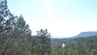
- Lewis & Clark National Historic Trail (52)
- Grand Canyon National Park (50)
- Golden Gate National Recreation Area (46)
- North Cascades National Park (42)
- Denali National Park & Preserve (40)
- Yellowstone National Park (40)
- Petrified Forest National Park (37)
- Mount Rainier National Park (32)
- Cape Hatteras National Seashore (28)
- Show More ...
- Geologic Resources Division (40)
- Wildland Fire Program (12)
- Inventory and Monitoring Division (8)
- North Coast and Cascades Inventory & Monitoring Network (8)
- Technical Preservation Services (8)
- American Battlefield Protection Program (7)
- National Heritage Areas Program (7)
- National Historic Landmarks Program (7)
- National Register of Historic Places Program (7)
- Show More ...
Showing 1,332 results for Northport ...
Chamizal National Memorial
Spring 2025: Ballet Folklorico
- Type: Article

Ballet Folklorico presents Paseo del Norte: Movement as Storytelling
Pecos National Historical Park
Glorieta Battlefield-North Loop
- Type: Place
Bryce Canyon National Park
RV Dump Station
- Type: Place

This RV Dump Station is typically open spring - fall, closing for the season when overnight temperatures fall below freezing. The dump station is located at the south end of North Campground and can be used by any visitor for a $5 use fee. No use fee applies for those with a campground reservation in the park. Potable water is available.
Rock Creek Park
Meridian Hill Park
- Type: Place
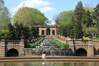
Meridian Hill Park, a few blocks north of the White House, features unique statues, concrete aggregate architecture, and the largest cascading fountains in North America.
The White House and President's Park
Zero Milestone
- Type: Place

This four-foot-high shaft of pink granite stands on the north and south meridian of the District of Columbia. It is symbolically the official starting point for measurement of highway distances from Washington, DC. On July 7, 1919, the first transcontinental military motor convoy, destined for San Francisco, California, started from this spot.
Sleeping Bear Dunes National Lakeshore
Katie Shepard
- Type: Person
Katie Shepard owned "The Beeches" hotel on North Manitou Island.
- Type: Place
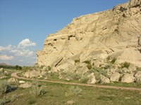
Following a day's journey from Fort Laramie, emigrants spent the night at Register Cliff , which rises one hundred feet above the North Platte River valley. The soft, chalky limestone rock made it easy for emigrants to inscribe their names into the cliff before continuing on their journey. The earliest signatures date to the late 1820s when trappers and fur traders passed through the area.
- Type: Place
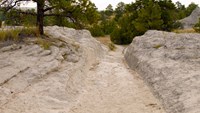
Oregon Trail Ruts State Historic Site , also called the Guernsey Ruts, is located where the geography of the area forced the Oregon Trail to change course. At this point, the Trail was blocked from continuing along the North Platte River by a steep ridge of sandstone rock. It had to go up and over the ridge in order to continue heading west.
- Type: Article

Guernsey, Wyoming, is situated along the North Platte River and the “Great Platte River Road”, a significant historic route followed by travelers on the Oregon, California, Pony Express, and Mormon Pioneer national historic trails. The small town is located along US 26, about 100 miles north of Cheyenne, Wyoming, and 66 miles west of Scottsbluff, Nebraska. Learn more about this area's rich history!
- Type: Article

A marine heatwave in the North Pacific had widespread, detrimental impacts on ecosystems and species. Why were some more resilient than others?
- Type: Place

The United Nations wall is the granite curb on the north side of the statues. This wall lists the 22 countries that gave combat or medical support to the UN forces.
Boston National Historical Park
REVOLUTION 250. Commemorations Bring People Together
- Type: Article

Faneuil Hall 2017 in Boston, Massachusetts is not the Faneuil Hall of 1767, Nor is Boston for that fact. Today, Faneuil Hall, and the adjacent Quincy Hall Marketplace, is an international destination for shoppers to the historic marketplace in the oldest part of Boston. Faneuil Hall, a gift to the residents of Boston from Peter Faneuil, allowed for a more formal marketplace and meeting hall which became the meeting place in Boston by the 1770’s. As tension grew with the m
Grand Canyon National Park
Pipe Creek Vista Bus Stop - Kaibab/Rim (Orange) Route
- Type: Place

Located west of Yaki Point and the South Kaibab Trailhead, this shuttle stop provides visitors with spectacular views across the canyon from South Rim to North Rim. The paved Canyon Rim Trail may be accessed here. This section of the Rim Trail is also part of the Greenway bicycle path, which runs east 0.9-mile (1.4 km) from here to the South Kaibab Trailhead and west 1.4-mile (2.3 km) to the Visitor Center. Visit the link for the current schedule.
Grand Canyon National Park
Market Plaza - Eastbound Bus Stop - Village (Blue) Route
- Type: Place

Located within Market Plaza, this shuttle stop is on the north side of Parking Lot B, right next to Yavapai Lodge (lodging, gifts, souvenirs, dining). Two J1772 EV charging stations are nearby. Across the parking lot from here, you can see Canyon Village Market and Deli (general store with groceries, souvenirs, and hiking gear), and the U.S. Post Office. From this bus stop, shuttles continue eastbound to Grand Canyon Visitor Center. Visit the link for the current schedule.
Grand Canyon National Park
Center Road Bus Stop - Village (Blue) Route
- Type: Place

This bus stop along the Village (Blue) Route provides direct access to Parking Lot C, a small public lot with 38 spaces, but often one of the last parking areas to fill during busy days. This stop is centrally located within the historic district of Grand Canyon Village with historic buildings located to the east, north and west of this point. Visit the link for the current schedule.
Grand Canyon National Park
Maswik Lodge
- Type: Place
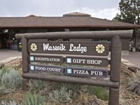
Maswik Lodge is a 250-room lodging complex nestled within several acres of ponderosa pine forest. The Food Court is open daily, 6 am to 9 pm. Pizza Pub: 4 pm to 9 pm, daily - First come, First Serve and Dine in Only. The lodge is located a short, 0.25-mile (0.4 km) walk from the canyon's edge. The main building has a registration desk, gift shop, food court, and a pizza pub. Two-story lodging units are located north and south of the main building.
- Type: Place
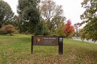
Battery Carroll and Fort Greble were two defense sites north of the Potomac that guarded the gateway to Washington during the Civil War. Fort Greble was named in honor of Lt. J.T. Greble who was killed at Big Bethel, Va., July 10, 1861.
Rock Creek Park
Parking at Picnic Grove #2 North
- Type: Place
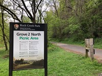
Parking Area with access to Beach Drive, Western Ridge Trail, Roosevelt Spur Trail and the Rock Creek Hiker/Biker trail.
Mount Rainier National Park
Huckleberry Creek Patrol Cabin
- Type: Place

This patrol cabin is located north of Sunrise near the park’s northern boundary.
Grand Portage National Monument
Fingerweaving
- Type: Article

Fingerweaving is the art of making material with the fingers instead of a loom. Prior to European contact Indigenous peoples in North America wove and twined with plants and animal fibers for a multitude of purposes. We know the beautiful, dense, warp-faced arrow and lightning motif sashes created by changing the weft that we associate with the Fur Trade are uniquely tied to North America.