Filter Your Results
- Golden Gate National Recreation Area (60)
- Lewis & Clark National Historic Trail (55)
- Grand Canyon National Park (39)
- Acadia National Park (32)
- Denali National Park & Preserve (27)
- North Cascades National Park (27)
- Point Reyes National Seashore (27)
- Big Bend National Park (23)
- Arches National Park (20)
- Show More ...
- National Center for Preservation Technology and Training (18)
- Archeology Program (13)
- Regions 3, 4, and 5 (13)
- Inventory and Monitoring Division (11)
- Natural Resource Condition Assessment Program (11)
- Natural Resource Stewardship and Science Directorate (9)
- Commercial Services Program (8)
- Harpers Ferry Center (8)
- Denver Service Center (7)
- Show More ...
Showing 991 results for Dogs ...
Chamizal National Memorial
Chamizal BARK Ranger - Getting Started
- Type: Place

Reconstruction Era National Historical Park
The Port Royal Experiment
- Type: Article

A few weeks after the Battle of Port Royal, US soldiers and sailors came ashore around Beaufort and found thousands of now formerly enslaved people in control of the region. The military had no real plan yet for what to do with these people or even their legal status.
Reconstruction Era National Historical Park
Series: The Port Royal Experiment
- Type: Article

In the fall of 1861 after the Battle of Port Royal, the US military came ashore around Beaufort and found thousands of now formerly enslaved people in control of the region. The military had no real plan yet for what to do with these people or even their legal status. Newly freed Black South Carolinians were active participants. They demanded access to programs to support labor reforms, land redistribution, quality education, and military service.
- Type: Article

Definitions underpin everything people do, and agreeing on them is essential for joint action. But how we define our nation’s forests is especially important because of their global and cultural significance.
Hagerman Fossil Beds National Monument
The Curious Case of the Old Dog in the Sand
- Type: Article

The discovery of a large fossil canid jawbone in Idaho gives clues to the region’s diverse, verdant past.
- Type: Article

In a world where excess light is wiping out our views of the stars at a startling pace, parks can protect natural darkness. But do nighttime visitors support the changes parks must make to bring back dark night skies? We didn’t know until we asked them.
Blue Ridge Parkway
Humpback Rocks Trailhead
- Type: Place

The short, strenuous climb to enjoy the view from the Humpback Rocks has drawn hikers for hundreds of years, across all seasons. There is much to see and do in the area beyond the hike to ‘the Rocks’ including access to the Appalachian National Scenic Trail, Glass Hollow Overlook, Old Howardsville Turnpike, Jack Albright Loop over Dobie Mountain, and true summit of Humpback Mountain. Along the way keep a sharp eye out for cultural resources and wildlife.
Lewis & Clark National Historic Trail
Proactive Protection of Natural Resources on the Lewis and Clark National Historic Trail
- Type: Article

Although NPS staff do not directly manage the land and resources along the Trail, we are able to positively impact land management through collaboration with partners and participation in planning efforts.
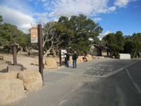
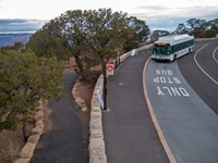
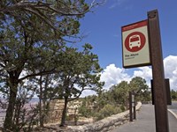
Grand Canyon National Park
Pipe Creek Vista Bus Stop - Kaibab/Rim (Orange) Route
- Type: Place

Located west of Yaki Point and the South Kaibab Trailhead, this shuttle stop provides visitors with spectacular views across the canyon from South Rim to North Rim. The paved Canyon Rim Trail may be accessed here. This section of the Rim Trail is also part of the Greenway bicycle path, which runs east 0.9-mile (1.4 km) from here to the South Kaibab Trailhead and west 1.4-mile (2.3 km) to the Visitor Center. Visit the link for the current schedule.
Grand Canyon National Park
Yaki Point Bus Stop - Kaibab Rim (Orange) Route
- Type: Place

Yaki Point is the only viewpoint on Desert View Drive that is closed to private vehicles. It can only be visited on foot, bicycle, or by taking the free Kaibab Rim (Orange) Route shuttle, departing from the Visitor Center Transit Terminal. Yaki Point is often a relatively quiet place from which to enjoy sunset or sunrise, with expansive views both to the east and west. Vault toilets are located here. Visit the link for the current schedule.
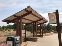
Grand Canyon National Park
South Kaibab Trailhead Bus Stop - Kaibab Rim (Orange) Route
- Type: Place
Just a 9-minute ride from Grand Canyon Visitor Center, this shuttle stop is the easiest way to access South Kaibab Trailhead. Running from 8 am, to just after sunset this winter, the bus will drop you off next to the water filling station and vault toilets, a short walk from the trailhead. From this location, you also can walk west along the paved Canyon Rim Trail and return to the Visitor Center, a distance of 2.3 miles/ 3.7 km. Visit the link for the current schedule.
Grand Canyon National Park
Yavapai Geology Museum Bus Stop - Kaibab Rim (Orange) Route
- Type: Place

Located on the northeast end of the parking lot below Yavapai Geology Museum, this shuttle stop is for passengers arriving from, or returning to the Visitor Center. The small restroom building is alongside this parking lot. The level footpath behind the shuttle stop goes to the outdoor amphitheater on the rim. Follow the path up the hill to Yavapai Geology Museum and Yavapai Point. The paved Canyon Rim Trail continues both east and west from here. Visit the link for schedule
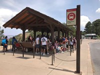
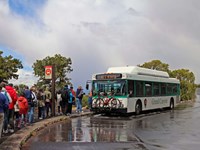
Grand Canyon National Park
Mather Point Bus Stop - Kaibab Rim (Orange) Route
- Type: Place
From the Visitor Center shuttle bus terminal, Mather Point is the first stop on the Westbound Kaibab/Rim (Orange) Route. From here the bus travels to Yavapai Geology Museum, then returns directly to the Visitor Center. From this bus stop, a very short walk to the east will take you to a wide open vista of Grand Canyon. However, the wheelchair accessible, Mather Point overlook is a short walk further east (to the right when facing the canyon). Visit link for current schedule.
Grand Canyon National Park
Village Transfer Station - Hermit Road (Red) Route
- Type: Place
NO BUS SERVICE during winter. Located west of Bright Angel Lodge, at the start of Hermit Road and beside a canyon overlook, this shuttle stop is just a few steps west of the Village (Blue) Route shuttle stop for the Hermit Road Interchange and Bright Angel Trailhead (at the top of the hill on your right. Hermit Road is a scenic 7-mile (11 km) road out to Hermits Rest, and the Hermit Trail. Along the way, there are 9 outstanding viewpoints, each with a designated bus stop.
Grand Canyon National Park
Hermits Rest Bus Stop - Hermits Rest (Red) Route
- Type: Place
NO BUS SERVICE on Hermit Road during December, January and February. The final shuttle stop on the Hermit Road (Red) Route, where shuttle buses turn around and begin their return trip back to the Village, Hermits Rest provides access to the only water bottle filling station along Hermit Road, restrooms, a snack bar, gift shop, Hermit Trail, the western end of the Rim Trail, and beautiful canyon views.
Grand Canyon National Park
Pima Point Bus Stop - Hermits Rest (Red) Route
- Type: Place
NO BUS SERVICE on Hermit Road during December, January and February. One of the few places where one can hear the Colorado River from the rim of Grand Canyon. Wait for the shuttle to pull away, then be as quiet as possible, and you might hear the faint roar of Granite Rapid far below, a sound which just barely hints at the power of a river more than 3 miles (4.8 km) away.
Grand Canyon National Park
Monument Creek Vista Bus Stop - Hermits Rest (Red) Route
- Type: Place

NO BUS SERVICE during December, January and February. A spectacular view of Monument Creek far below and Granite Rapid on the Colorado River can be seen directly from this shuttle stop. This viewpoint is the eastern end of a section of the Greenway Trail, which accommodates both walking and bicycling, which runs west from here past Pima Point almost all the way to Hermits Rest.
Grand Canyon National Park
The Abyss Bus Stop - Hermits Rest (Red) Route
- Type: Place
NO BUS SERVICE during December, January and February. The Abyss shuttle bus stop is outbound only, to Hermits Rest. At the Abyss Overlook, impressive canyon views are rivaled by the 3,000 foot (914 m) vertical drop below you. This stop offers a unique place to discover how gravity can profoundly affect the shape of the canyon walls.
Grand Canyon National Park
Mohave Point Bus Stop - Hermits Rest (Red) Route
- Type: Place

NO BUS SERVICE during December, January and February. A two-way shuttle stop with separate buses headed both outbound (west) to Hermits Rest and inbound (east) back to the Village, Mohave Point features a spectacular view from the shuttle stop. The main viewpoint, however, is a short walk down the paved trail from the shuttle stop. Mohave Point primarily faces west, with a great view of the Colorado River far below, making this point a popular place for sunset.
Grand Canyon National Park
Hopi Point Bus Stop - Hermits Rest (Red) Route
- Type: Place

NO BUS SERVICE during December, January and February. From this stop, follow the path to the right (east) for a more open vista of the canyon at Hopi Point, Also the only vault toilet along Hermit Road between the village and Hermits Rest. Hopi Point is popular for sunrise and sunset. During the day, this stop is OUTBOUND only (to Hermits Rest). After sunset, special buses transport visitors INBOUND - back to the Village, picking up passengers at Hopi Point itself.