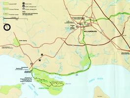
NPS Image Situated on the banks of the James River, Jamestown is a short distance from many major roadways and highways. For a google map search or GPS, use the following address: 1368 Colonial Parkway, Jamestown, Virginia 23081. FROM INTERSTATE 64 (I-64) When traveling east or west on I-64 take exit 242A . To reach Historic Jamestowne from the east take Interstate 64 West to the intersection of Route 199 West, Exit 242A. Follow 199 West to the Colonial Parkway, then follow the signs to Historic Jamestowne. From the west: Take Interstate 64 East to Route 199 West, Exit 242A. Follow 199 West to the Colonial Parkway, then follow the signs to Historic Jamestowne. FROM WILLIAMSBURG Take Colonial Parkway 9 miles south to the Historic Jamestowne Visitor Center. Again, welcome to Historic Jamestowne. FROM THE YORKTOWN AREA Take the Colonial Parkway 24 miles to the Historic Jamestowne Visitor Center. Again, welcome to Historic Jamestowne.
Public Transportation
| |
Last updated: September 12, 2022
