Our park features many excellent walking and hiking trails, boasting both historical significance and natural beauty. As you explore the park, the following hiking trail guides, maps, and brochures for sites will help you plan your journey and find your way around.
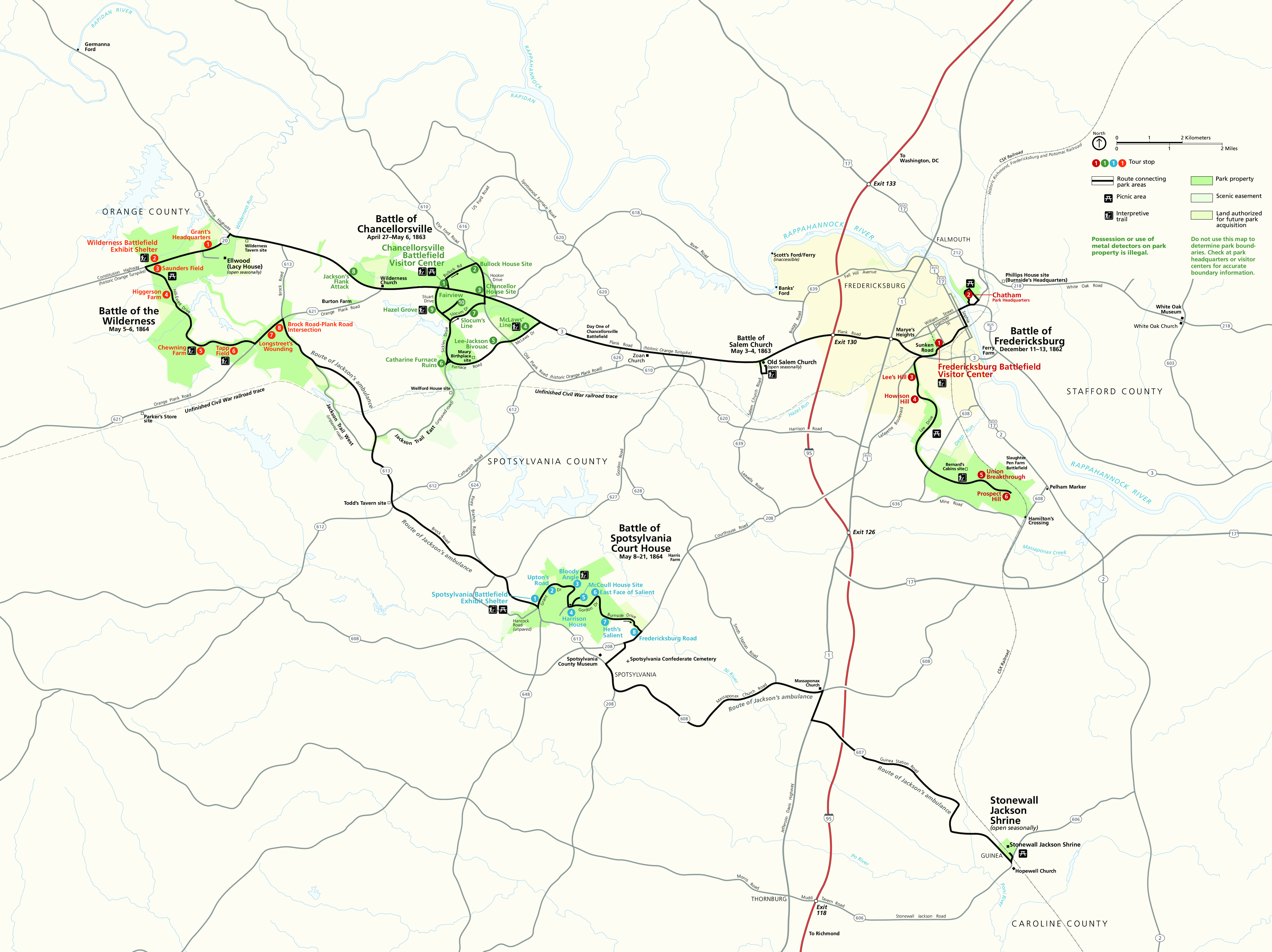
Most of these sites and trails correspond with driving tour locations shown here in the overall park map.
Fredericksburg Battlefield
- Chatham Grounds Map (pdf): This historic slave plantation has reflected the history of the American South for over 250 years. Learn more about Chatham Manor.
- Sunken Road Walking Trail Map (pdf): 0.8 mi (1.3 km) loop. Start: Fredericksburg Battlefield Visitor Center, Tour Stop 1. Follow the historic Sunken Road and climb to Marye's Heights leading to the Fredericksburg National Cemetery.
- North Lee Drive Trail Map (pdf): 2.8 mi (4.5 km) one way. This trail follows the course of North Lee Drive. There is no informational signage along the trail.
- Lee Hill Trail (no map): 0.5 mi (.8 km) round trip. Start: Lee's Hill, Tour Stop 3. Climb a winding trail to the top of Lee's Hill, Robert E. Lee's command post during the battle.
- South Lee Drive Trail Map (pdf): The following trails are accessible from South Lee Drive:
- South Lee Drive Trail: 2.4 mi (3.9 km) one way. This trail follows the course of South Lee Drive. There is no informational signage along the trail.
- Bernard's Cabins Trail: 1.8 mi (2.9 km) round trip. Start: Pullout along north side of South Lee Drive, between Tour Stops 4 & 5. Follow this trail to the location of cabins where enslaved people lived and an artillery position during the Battle of Fredericksburg.
- Hamilton's Crossing Walking Trail: 0.64 mi (1 km) round trip. Start: Prospect Hill, Tour Stop 6. A short trail that leads to the site of Hamilton's Crossing, an important rail depot.
- Downtown Fredericksburg: The Battle of Fredericksburg took place over a much wider area than what the park currently manages, including the town itself. The following walking tours cover the streets of Fredericksburg:
Chancellorsville Battlefield
- Jackson Wounding Trail (no map): 0.2 mi (.3 km) loop. Start: Chancellorsville Battlefield Visitor Center. Take this short, rubber-pact trail around the visitor center to follow Jackson's wounding.
- Chancellorsville History Trail Map (pdf): 4.3 mi ( 6.9 km) loop. Start: Chancellorsville Battlefield Visitor Center parking lot. Follow in the footsteps of Confederate soldiers hammering against the Union defense on the morning of May 3, Chancellorsville crossroads and house site, the Bullock House Site, and the apex of Hooker's last line.
- Hazel Grove-Fairview Trail Guide (pdf): 1.7 mi (2.7 km) round trip. Start at either Hazel Grove, Tour Stop 9, or Fairview, Tour Stop 10. Walk the trail that links two artillery positions, where, on the morning of May 3, five hours of intense fighting left a man killed, wounded, or captured, every second.
- McLaws Line Trail (pdf):1.1 mi (1.7 km) loop. Start: McLaw's Line, Tour Stop 4. Follow the story of the men whose diversionary tactics kept Union attention away from "Stonewall" Jackson's flank march on May 2, 1863.
Wilderness Battlefield
- Wilderness Crossing Trail (pdf): 1.5 mi (2.4 km) round trip. Start: Ellwood's driveway. Explore the plantation grounds and dusty crossroads that defined this break in the Wilderness. When Ellwood is closed, park at the Ellwood gate, walk .5 mi (.8 km) to the trailhead.
- Gordon Flank Attack Trail (pdf): 2.1 mi (3.4 km) loop. Start: Wilderness Battlefield Exhibit Shelter, Tour Stop 2. Follow the historical earthworks remaining from a crushing Confederate flank attack late on May 6, 1864.
- Vermont Monument Trail (pdf): 0.4 mi (.7 km) loop. Start: Brock Road-Plank Road Intersection, Tour Stop 8. Walk the same ground as the renowned Vermont Brigade and see the memorial to this unit which bore the brunt of the fighting in this area.
- Widow Tapp Farm Trail (pdf): 1 mi (1.6 km) round trip. Start: Tapp Field, Tour Stop 6. As the battle hung in the balance on the edge of this field, Confederate reinforcements arrived here just in time to save the Army of Northern Virginia.
- Federal Line Trail (pdf): 7.2 mi (11.6 km) round trip. Start: Picnic area south of Saunders Field, Tour Stop 3. Walk the length of the Union line, featuring remarkable earthworks and artillery positions.
Spotsylvania Court House Battlefield
- Bloody Angle Trail (pdf): 1.1 mi (1.8 km). Start: Bloody Angle, Tour Stop 3. Walk the ground where, on May 12, 1864, Union soldiers launched a massive assault against a bulge in Confederate works called the Mule Shoe Salient. The 22 hours of hand-to-hand combat that followed lent this place its name, the Bloody Angle.
- Spotsylvania History Trail (pdf): 5.7 mi (9.2 km) loop. Start at any parking area intersecting with the trail. This trail weaves throughout most of the Spotsylvania Battlefield, passing much of the 14 miles of earthworks on the battlefield and covering the majority of tour stops.
|