|
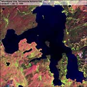
Lobby > Exhibits > Scientific Research > What Lies Beneath > A Lakeside Mystery A Lakeside Mystery Scientists reasoned that perhaps the ground itself was tilting. To test this theory, they resurveyed a series of elevation benchmarks that had originally been measured in 1923, and found a dramatic difference. The central part of Yellowstone had risen by 2.5 feet (75 cm) and the greatest uplift appeared to be near the northern end of the lake. Subsequent mapping of old shorelines of Yellowstone Lake revealed that a slow back and forth tipping has been going on for thousands of years. By the mid 1980s, the ground level had started to subside again. Next | 1 > 2 > 3 | Next Section: Monitoring Yellowstone's Heartbeat |
|
||||||||||||||||||||||||||||||
 In the early 1970s, park scientists noticed that trees on the south shore of Yellowstone Lake were dying. Water on that side of the lake appeared to be rising. In contrast, the shoreline on the north side of the lake appeared to be falling. The lake was acting like a pan of water being tipped to one side.

