|
The characteristic four seasons of the continental United States give way in southernmost Florida to only two seasons: wet and dry. South Florida's subtropical climate is characterized by warm, humid, rainy summers and mild, dry, pleasant winters with periodic incursions of cool air. Visit the following National Weather Service links for current weather conditions and forecasts: Summer: The Wet Season 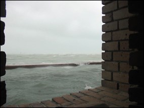
NPS photo Although summers are hot and humid, the high temperatures are tempered by frequent thunderstorms. The summer wet season extends from about mid-May to November, with average temperatures ranging up to about 90 degrees Fahrenheit (32 degrees Celsius). The majority of the year's average annual rainfall (about 40 inches, or 102 cm) falls during the wet season. Continental cold fronts generally cannot penetrate as far south as south Florida during the summer, so warmth and humidity build. Thunderstorms arise when warm, moist air masses combine with an unstable atmosphere. They can be as brief as a few minutes or as long as several hours. At times, these thunderstorms can be an almost daily occurrence. Sometimes these storms move very slowly, enabling them to drop several inches of rain. The largest amounts of rainfall typically are associated with tropical storms and hurricanes. Heat Index Park visitors need to be aware of the heat index, which is a measure of how hot it feels. Other names for the heat index include the felt air temperature or apparent temperature. The heat index combines air temperature and relative humidity in an attempt to determine the human-perceived equivalent temperature. For example, for a temperature of 90 degrees Fahrenheit (32 degrees Celsius) experienced under very high humidity, the heat index is about 105 degrees Fahrenheit (41 degrees Celsius). The human body normally cools itself by perspiration, or sweating. Evaporation of that sweat removes heat from the body; however, relative humidity reduces the evaporation rate because the higher moisture content of the surrounding air inhibits evaporation. The lower heat removal rate from the body results in the sensation of feeling overheated. The effect is subjective, and its measurement is based on descriptions of how hot subjects feel for a given temperature and humidity. Visitors are advised to consider the heat index when planning activities in the park. Hurricanes 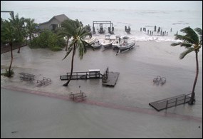
NPS photo The Atlantic hurricane season officially begins on June 1 and ends November 30. Hurricanes are a violent type of tropical cyclone that forms over warm ocean waters, typically beginning as storms in the Caribbean or off the west coast of Africa. As they drift, they are fueled by the warm waters of the tropics. Warm, moist air moves toward the center of the storm, spirals upward, and is released as torrential rains. The cycle of strengthening ends only when contact is made with land or cooler water and the supply of moisture is cut off. Situated almost 70 miles west of Key West, Dry Tortugas National Park lies within one of the most active hurricane areas of the United States. Visitors should be aware that all or part of the park may be closed before, during, and after severe weather events. For the latest information on park status and operations, please contact the main switchboard at 305-242-7700 or check online at www.nps.gov/drto. 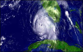
Satellite image courtesy of NOAA By definition, a tropical cyclone is a rotating, organized system of clouds and thunderstorms that originates over tropical or subtropical waters and has a closed low-level circulation. Tropical cyclones rotate counterclockwise in the Northern Hemisphere. They are classified as follows:
Winter: The Dry Season 
NPS photo The winter dry season extends from about November to mid-May, with temperatures ranging from the low 60s to mid 70s (18 to 24 degrees Celsius). Because winter weather conditions are typically windier than summer conditions, seas are generally rougher on a typical day with no storm influence. Continental weather fronts occasionally bring cooler temperatures, which, coupled with the often-breezy winter conditions, can create a wind chill factor that makes perceived temperatures feel considerably cooler than what the thermometer reads. South Florida receives only about one quarter of its average yearly rainfall during the winter dry season. From late fall through early spring, continental cold fronts periodically plunge southeastward through the state, sweeping away any warm, humid air. Cool, dry air stabilizes the atmosphere, suppressing any showers and thunderstorms. Any rain associated with these frontal passages typically arrives in the form of squall lines that sweep through so quickly that they have little opportunity to drop substantial amounts of rain. Average Weather Conditions The following table provides monthly averages for temperature and precipitation at the Key West Airport, which is about 70 miles east of Dry Tortugas National Park. Data source: Southeast Regional Climate Center.
The Difference between Weather and Climate The difference between weather and climate is a measure of time. Weather is what conditions of the atmosphere are over a short period of time, and climate is how the atmosphere "behaves" over relatively long periods of time. Climate change refers to changes in long-term averages of daily weather. Latitude and the large amount of surrounding marine waters are the primary factors that affect the climate of Dry Tortugas National Park. Proximity to the warm, oceanic currents that flow from the Caribbean, through the Gulf of America, and through the Florida Straits into the Atlantic Ocean also plays an important role. 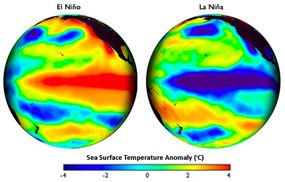
Images courtesy of Steve Albers, NOAA During the 1800s, local fishermen on the Pacific coast of South America began noticing a warm ocean current. The warm water arrived around Christmastime each year. Referring to the birth of Christ, they named this current El Niño, which means "the boy" in Spanish. El Niño is now known to be much more than just a local current off the coast of Peru. An El Niño condition is when surface water in the Pacific, near the equator, becomes warmer and the winds blow weaker than normal from the east. The opposite condition, when the water is colder than average and winds are blowing stronger from the east, is called La Niña. El Niño and La Niña episodes typically occur every 3 to 5 years. These interactions of the ocean and atmosphere produce important consequences for people and ecosystems in many parts of the globe. Weather patterns in many parts of the world are influenced by El Niño and La Niña. Humans and ecosystems can be positively and negatively affected. During the fall through spring, El Niño typically causes increased rainfall and sometimes destructive flooding across the southern parts of the United States. During the same seasons, La Niña typically causes drier weather in the southern United States and colder and wetter weather in the Northwest. Even though El Niño occurs in the Pacific, it often reduces the number of hurricanes that form in the Atlantic. Conversely, La Niña episodes tend to increase the number of hurricanes in the Atlantic. The Influence of Dust on Weather and Climate 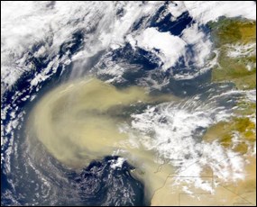
Satellite image courtesy of NASA African dust blown across the Atlantic Ocean by winds has been affecting air quality and producing striking sunsets in south Florida for ages. NASA scientists recently discovered that tiny particles of dust originating in the Saharan Desert affect the size of a thunderstorm's anvil (top), the strength and number of warm updrafts, and the amount of rain that builds up and falls from convective (heat generated) thunderstorms in Florida. When Saharan dust is in the air, the thunderstorm anvils created by Florida's convective thunderstorms tend to be a little smaller in area, but they tend to be better organized and thicker. This affects the amount of incoming sunlight and warmth reaching the ground, which can have effects on long-term climate. The amount of airborne dust increases during periods of drought in Africa. 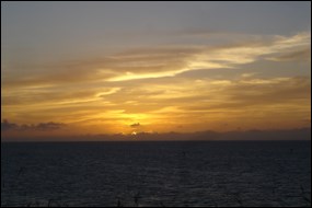
NPS photo Volcanic ash that is spewed into the stratosphere by erupting volcanoes around the globe has a similar effect on air quality and climate. In the form of dust and aerosols, the finer particles remain aloft for years and spread around the world, scattering light and helping to produce the vivid, picture-perfect sunrises and sunsets that Florida is famous for. | ||||||||||||||||||||||||||||||||||||||||||||||||||||||||||||||||||||||||||||||||||||||||||||||||||||||||
Last updated: February 24, 2025

