Maps


Use these maps to locate our visitor center, trailheads, trail routes, and other points of interest. Printed versions of most maps are available at Boston Mill Visitor Center or you can contact us to request a mailed copy. Additional formats of some maps are available on a separate cartography website. We recommend downloading the NPS App for access to the interactive map and other park information on the go.

Use the drop down menu for quick access to specific maps. Find more information about trails on our hiking page.

Note: To save a map from this page, right-click the image and select "Save image as..." to download it to your device.

Cuyahoga Valley National Park Official Interactive Map

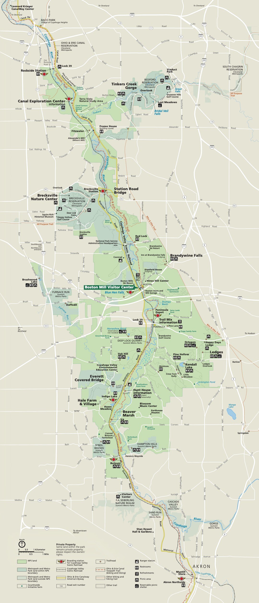
The map shows our visitor center and other attractions:


Cuyahoga Valley National Park Map

 
A map of the entire area of Cuyahoga Valley National Park from Rockside Station in the North to Akron in the South. Markers indicate destinations across the park as well as various amenities and roadways.
Map of Cuyahoga Valley National Park.

This park map appears on one side of our park brochure. For the full audio description of the map visit our Park Brochure Formats page.
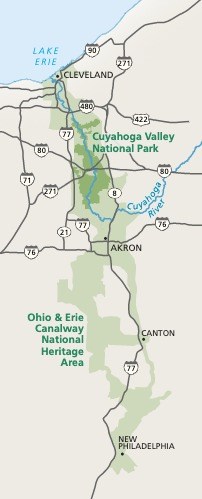
 
A map of the area of Cuyahoga Valley National Park (CVNP), Ohio & Erie Canalway National Heritage Area, as well as the areas immediately surrounding both the park and the National Heritage Area.
An area map of Cuyahoga Valley National Park, the Ohio & Erie Canalway National Heritage Area, and the surrounding region.

Cuyahoga Valley National Park Area Map

Shown in dark green on this map, Cuyahoga Valley National Park is around 22 miles south of Cleveland and Lake Erie. The Boston Mill Visitor Center is around 18 miles north of Akron. The park can be accessed from several nearby highways, visit our Directions page for more information.

The two closest National Park Sites to Cuyahoga Valley National Park are the James A. Garfield National Historic Site in Mentor, Ohio and the First Ladies National Historic Site in Canton, Ohio. Check out our Nearby Attractions page to learn more about the area surrounding Cuyahoga Valley National Park.


Trail Map: Station Road to Boston

Click the link to download a printable and accessible version of the Station Road to Boston Map.

 
The major trails, roads, and locations from Station Road Bridge to Boston Mill Visitor Center with their amenities. Riverview Road runs through the middle of the park with Station Road Bridge, Jaite, and Boston located off Riverview Rd.
Map of Cuyahoga Valley Trails from Station Road to Boston.
 

Trail Map: Boston to Everett

Click the link to download a printable and accessible version of the Boston to Everett Map.

 
Map of the Cuyahoga Valley Trails from Boston to Everett
Map of the Cuyahoga Valley Trails from Boston to Everett.
 

Brandywine Falls Area Trails

 
Trail map with black bar at top and white text, " Brandywine Falls Area Trails"; includes information about the roads and trails leading to the falls, including Brandywine Gorge Loop and Stanford Trail.
Map of the trails in the Brandywine Falls Area.
 

Kendall Lake Area Trails

Click the link to download a printable and accessible version of the Kendall Lake Area Trail Map.
 
Salt Run, Lake, and Cross Country Trails around Kendall Lake and Hills. Salt Run Trail, 3.3-mile loop, 160 feet elevation change. Lake Trail, 1 mile loop, 20 feet elevation change, stairs. Cross Country Trail, 2.5-mile loop, 160 feet elevation change.
Area map of the Kendall Lake trails.
 

Ledges Area Trails

Click the link to download a printable and accessible version of the Ledges Area Trail Map.
 
Ledges Trail, 2.2-mile loop, 105 feet elevation change, steep stairs. Pine Grove trail, via Octagon, 2.2-mile loop, 100 feet elevation change. Forest Point from Octagon, 0.5-mile loop. Haskell Run trail, 0.5-mile loop, 70 feet elevation change.
Map of the Ledges area and trails.
 

Boston Run Trail

 
Boston Run trail off State Route 303 starts from the Happy Days Lodge parking lot. A 3.1-mile loop with 80 feet elevation change. Connect to Haskell Run and Ledges Trail for a longer hike.
Map of Boston Run Trail.
 

Everett Area Trails

 
Trail map with black bar at top and white text, "Everett Area Trails"; includes information about Riding Run Trail, Furnace Run Trail, and Valley Trail.
Map of the Everett area trails.
 

Wetmore Area Trails

 
Trail map with black bar at top and white text, "Wetmore Area Trails"; includes information about Wetmore Trail, Butlers Trail, Langes Run Trail, Tabletop Trail, and Valley Trail.
Map of the Wetmore area trails.
 

Oak Hill and Plateau Trails

 
A map of the 1.8 mile Oak Hill Trail and the 4.6 mile Plateau trail. Both are loop trails off of Oak Hill Road at Oak Hill Trailhead. The trailhead has parking, restrooms, picnic tables, and the trails can be used to cross country ski in the winter.
Map of the Oak Hill area trails.
 

Tree Farm Trail

 
Tree Farm Trail starts from the Horseshoe Pond parking lot. A 2.75-mile loop with 80 feet elevation change. Access the trail from Major Road, located south of Peninsula off Riverview Road.
Map of Tree Farm Trail.
 

East Rim Mountain Bike Trails

 
A map of the East Rim trail system, a 2.3-mile East Rim Trail, 4.7-mile Lamb Loop, and 1.3-mile Edson Run.
The East Rim Trail System is made up of the 2.3-mile East Rim Trail, Post Line boulder field, 4.7-mile Lamb Loop, and 1.3-mile Edson Run.

Last updated: September 27, 2024

Park footer

Contact Info

Mailing Address:

15610 Vaughn Road
Brecksville, OH 44141

Phone:

440 717-3890

Contact Us