Research

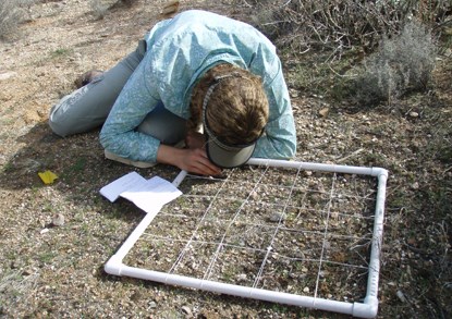
Inventory is being done by using a portable grid and close studies.
Portable quadrats are one tool for monitoring vegetation and soils.

NPS

Scientific research is key to protecting the natural and cultural wonders of our national parks. To make sound decisions, park managers need accurate information about the resources in their care. They also need to know how and why systems and landscapes change over time, and what amount of change is normal.

Like a physician monitoring a patient's heartbeat and blood pressure, scientists with the Sonoran Desert Network collect long-term data on park “vital signs"—key resources that can indicate overall ecosystem health. At Casa Grande Ruins National Monument, they monitor air quality, climate, groundwater, and vegetation and soils. Then they analyze the results and report them to park managers. Knowing if and how key resources are changing can provide managers with early warning of potential problems, when they are easier—and less expensive—to fix. It can also help them to make decisions and plan more effectively.

Studying park vital signs is only part of the picture. Scientific research is also conducted by park staff, other state and federal scientists, university professors and students, and independent researchers. Because many parks prohibit activities that occur elsewhere, scientists can use the parks as "control" areas for determining the effects of these activities where they do occur. Especially in the American West, national park lands often serve as the best model for what a relatively undisturbed landscape looks like.


Quick Reads

Showing results 1-10 of 20

    • Locations: Acadia National Park, Agate Fossil Beds National Monument, Alibates Flint Quarries National Monument, Amistad National Recreation Area, Antietam National Battlefield,
    • Offices: Appalachian Highlands Inventory & Monitoring Network, Chihuahuan Desert Inventory & Monitoring Network, Cumberland Piedmont Inventory & Monitoring Network, Eastern Rivers and Mountains Inventory & Monitoring Network, Great Lakes Inventory & Monitoring Network,
    Green, orange, and dead grey junipers in red soil, mountains in background

    Across the US, changes in water availability are altering which plants grow where. These changes are evident at a broad scale. But not all areas experience the same climate in the same way, even within the boundaries of a single national park. A new dataset gives park managers a valuable tool for understanding why vegetation has changed and how it might change in the future under different climate-change scenarios.

    • Locations: Casa Grande Ruins National Monument
    • Offices: Geologic Resources Division
    casa grande ruins

    Each park-specific page in the NPS Geodiversity Atlas provides basic information on the significant geologic features and processes occurring in the park.

    • Locations: Abraham Lincoln Birthplace National Historical Park, Acadia National Park, Agate Fossil Beds National Monument, Alibates Flint Quarries National Monument, Allegheny Portage Railroad National Historic Site,
    • Offices: Inventory and Monitoring Division, Natural Resource Stewardship and Science Directorate, Northeast Coastal and Barrier Inventory & Monitoring Network, Northeast Temperate Inventory & Monitoring Network, Northern Colorado Plateau Inventory & Monitoring Network,
    A toad sits on red sand, looking into the camera.

    To steward amphibians effectively, managers need basic information about which species live in parks. But species lists need constant maintenance to remain accurate. Due to recent efforts, the National Park Service now has an up-to-date amphibian species checklist for almost 300 parks. This information can serve as the basis for innumerable conservation efforts across the nation.

    • Locations: Casa Grande Ruins National Monument
    • Offices: Sonoran Desert Inventory & Monitoring Network
    The blue and orange sunset behind the silhouette of unique ruins.

    Sonoran Desert Network scientists take measurements of key resources at Casa Grande Ruins to understand how natural resources in the park may be changing over time. This report summarizes analyses of weather and groundwater data from water year 2022. The data indicate the park is in mild drought though groundwater levels remain stable. Temperatures were warmer than average. Ten months had below average rainfall, but two months experiencing extreme precipitation.

    • Locations: Casa Grande Ruins National Monument, Chiricahua National Monument, Coronado National Memorial, Fort Bowie National Historic Site, Glen Canyon National Recreation Area,
    A small black lesser long-nosed bat with a black face hovers above a waxy white saguaro flower.

    Lesser long-nosed bats have been in scientific focus since the late 1900's. These unique animals face different obstacles in their changing environment, but researchers are at work in Organ Pipe Cactus National Monument, learning more about these bats. Through research here and throughout Central America, scientists are understanding better how to protect these animals and their environment.

    • Locations: Arches National Park, Aztec Ruins National Monument, Bandelier National Monument, Bent's Old Fort National Historic Site, Big Bend National Park,
    • Offices: Chihuahuan Desert Inventory & Monitoring Network, Climate Change, Climate Change Response Program, Inventory and Monitoring Division, Mediterranean Coast Inventory & Monitoring Network,
    Dark storm clouds and rainbow over mountains and saguaros.

    When the climate changes enough, the vegetation communities growing in any given place will also change. Under an expanded bimodal climate zone, some plant communities in western national parks are more likely to change than others. National Park Service ecologists and partners investigated the future conditions that may force some of this change. Having this information can help park managers decide whether to resist, direct, or accept the change.

    • Locations: Aztec Ruins National Monument, Bandelier National Monument, Canyon de Chelly National Monument, Casa Grande Ruins National Monument, Chaco Culture National Historical Park,
    • Offices: Inventory and Monitoring Division, Natural Resource Stewardship and Science Directorate, Sonoran Desert Inventory & Monitoring Network
    American flag viewed through the remains of an adobe doorway.

    In the US Southwest, climate change is making it harder to preserve historic adobe structures for future generations. Using adobe test walls and rainshower simulators, staff at the Desert Research Learning Center are evaluating the potential for increased erosion, and testing the effectiveness of different treatments methods to protect against it. The results will help park managers tailor their preservation methods to better protect culturally valuable resources.

    • Locations: Alibates Flint Quarries National Monument, Amistad National Recreation Area, Arches National Park, Aztec Ruins National Monument, Bandelier National Monument,
    • Offices: Chihuahuan Desert Inventory & Monitoring Network, Greater Yellowstone Inventory & Monitoring Network, Inventory and Monitoring Division, Natural Resource Stewardship and Science Directorate, Northern Colorado Plateau Inventory & Monitoring Network,
    A man looks through binoculars at sunrise.

    Across the Intermountain Region, Inventory & Monitoring Division ecologists are helping to track the effects of climate change, provide baseline information for resource management, evaluate new technologies, and inspire the next generation of park stewards. This article highlights accomplishments achieved during fiscal year 2021.

    • Locations: Casa Grande Ruins National Monument
    • Offices: Archeology Program

    Although it was built close to 700 years ago, the Casa Grande remains one the tallest structures in the town of Coolidge, Arizona. The Casa Grande is probably the most significant surviving example of Hohokam building techniques and architecture made from caliche, a concrete-like mixture of sand, clay, and calcium carbonate (limestone).

    • Locations: Casa Grande Ruins National Monument, Chiricahua National Monument, Coronado National Memorial, Fort Bowie National Historic Site, Gila Cliff Dwellings National Monument,
    • Offices: Inventory and Monitoring Division, Natural Resource Stewardship and Science Directorate, Sonoran Desert Inventory & Monitoring Network
    Two men at the edge of a marsh. One crouches. The other holds a long metal rod with a disc on top.

    The Heliograph is the newsletter of the Sonoran Desert Network and Desert Research Learning Center. In this issue, find out how eDNA inventories may change what we thought we knew about SODN springs. Learn about the new technology that will improve our streams monitoring, and the lasting contributions of our IVIPs to projects across multiple networks. Get caught up on our latest reports and the status of ongoing projects, and find out what’s happening at the DRLC.


Source: Data Store Saved Search 3692 (results presented are a subset). To search for additional information, visit the Data Store.


Park Species List


Select a Park:

Select a Species Category (optional):

List Differences

Search results will be displayed here.


Visit NPSpecies for more comprehensive information and advanced search capability. Have a suggestion or comment on this list? Let us know.

Last updated: November 24, 2020

Park footer

Contact Info

Mailing Address:

1100 W. Ruins Drive
Coolidge, AZ 85128

Phone:

520 723-3172
General park contact number includes a phone tree for finding the employee you wish to contact. Callers may dial zero for the phone attendant. Voicemail is available for many of the extensions.

Contact Us