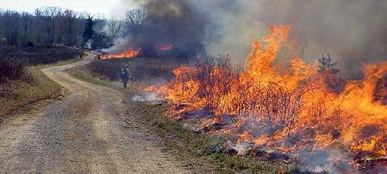
During the next 6-8 weeks, National Park Service fire crews will be conducting a series of prescribed fires within Big South Fork National River and Recreation Area. The prescribed fires, as defined in the park's Fire Management Plan, will all be located within the boundaries of the park. Plans call for burns varying in size from 38 to 2,080 acres to occur at locations in both Kentucky and Tennessee.
Through years of scientific research we have learned that fire is an essential, natural process. It has helped shape our woodlands for thousands of years, and is important for the survival of many plants and animals. Fires remove the layers of dead and down trees, leaves and other vegetation from the forest floor that can inhibit plant growth and recycle the nutrients back into the environment. Fire also increases the diversity of plant and wildlife habitat; some plants, such as American Chaffseed, have disappeared from the park because they need fire to reproduce.
Prior to human settlement, the fire history of the Southern Appalachian Region was a pattern of small, low intensity fires interspersed over the landscape at irregular intervals with occasional large fires. The frequency at which fires occurred increased with the arrival of humans about 10,000 years ago. European settlers used fire to clear land and facilitate farming and grazing in to the early 1900s.
The Bald Knob Project is located in the northwestern area of the park in McCreary County, Kentucky; the project encompasses approximately 2,080 acres of land immediately adjacent to the Bald Knob community and the Ledbetter Trailhead. The Newtie King Project is located in the northeastern area of the park in McCreary County, Kentucky; the project encompasses approximately 137 acres of land in the Split Bow Arch and Bear Creek Overlook area. The Monroe Fields Project is also located in the northeastern area of the park in McCreary County, Kentucky; the project encompasses approximately 84 acres of land in the Bear Creek Horse Camp area. The Mitchell Field Project is located in the Duncan Hollow area of the park in Scott County, Tennessee; the project encompasses approximately 38 acres of land about two miles north of the Bandy Creek Campground.
Ignitions are scheduled to occur in March and April. Only when the weather and conditions meet the defined prescription will the fires be ignited. Ignitions will not occur every day. In addition to meeting specific conditions, crews of 25-40 firefighters and several engines will be on hand for each burn. Any park neighbor who may be impacted will be contacted prior to ignition.
During a prescribed burn all roads and trails in the burn area will be temporarily closed for visitor safety.
Please contact the park's Bandy Creek Visitor Center at (423) 286-7275 for the latest information on the current status of the prescribed burns and associated closures.