
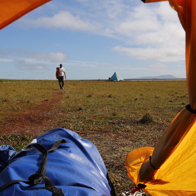
NPS photo / Jim Pfeiffenberger Hiking and backpacking in and around Bering Land Bridge National Preserve can be an adventurer’s dream. Backpackers will find many opportunities to explore the vast expanse of tundra terrain and see the preserve’s unique features. Backcountry permits are not issued; people are able to visit the preserve on their own accord. Things to consider when planning your backcountry trip.

NPS Photo Terrain Challenges and DescriptionsHiking and backpacking in the preserve can be difficult and can vary depending on where you are and the season you visit. Coastal terrain is windier, which can act as a mosquito deterrent during the warmer months, and typically has milder weather. The interior of the preserve may have a considerable amount of mosquitos and greater seasonal variation. The terrain may vary from large thickets of shrubs to wetlands. TundraLow wetlands with a lot of tussock vegetation can be difficult to walk on. Imagine walking on top a field of soggy cabbages. ThicketsHiking in the backcountry may require bushwhacking through dense thickets. Willow and alder brush may exceed six feet (two meters) in height, and the thickness of brush often limits visibility, requiring hikers to yell or talk loudly to reduce the chance of unwanted wildlife encounters. Areas of extensive bushwhacking makes for slow and often frustrating travel. RidgelinesHiking along ridgelines in the preserve provides fast, comparatively easy travel. Brush is usually minimal and therefore visibility is often greater than in other terrain and the surface is more durable. Lava FieldsHiking on the lava field is feasible and is easier to walk on than tussocks; however, the jagged terrain still makes it "ankle-twisting ground." There are no active lava fields in the preserve. River CrossingsThere are no bridges across rivers in the backcountry. You must negotiate your own river crossings and pack gear accordingly to keep dry in the event of an accidental swim. Water temperature may be approximately 36º F (2º C), and a cold immersion may result in high risk of hypothermia. Try to cross where the river is braided and dispersed, rather than concentrated into a single deep, narrow channel. River depths can also vary widely during a trip, depending on time of year, rainfall, and temperatures. After ice breakup, usually in spring, river crossings can be more dangerous due to the increase of snow melt. Trekking poles or sticks can be useful in checking river depth if the bottom is not visible. Keep hiking boots on while crossing rivers to provide maximum protection for your feet and to give you traction on river bottoms. If you choose, you can bring an extra pair of shoes to switch into while at camp. Topo MapsPlanning a backcountry trip into the preserve can be challenging. Study the terrain you are planning to hike. Topographical maps are available for download via the USGS website. You Might Also Like
|
Last updated: January 6, 2026