Monitoring Wildland Fires
The primary objective of the organization is to manage all naturally caused wildfire events as an ecological process to the greatest extent practical while minimizing risk to life (public and firefighters), private property and identified sensitive resources. This objective is accomplished through extensive pre-planning and collaboration with internal/external stakeholders and organizations. The entire Park Unit and the vast majority of Alaska has identified where risk is generally acceptable to allow natural wildfire to occur to the fullest extent and duration. Denali National Park and Preserve has 3,359,449 acres (out of a total of 6+ million) that are covered by burnable vegetation. Eighty-nine percent of the burnable vegetation acres (2,983,460 acres) and 97% of the entire Park Unit lie within this designation. This generally allows wildfire to play its natural role in the ecosystem. Conversely, due to the presence of people, infrastructure, sensitive features and/or adjacent lands stakeholders concerns the remaining 3% of the Denali land base is prioritized to have increased fire protection and/or suppression. In these areas this does not preclude the presence of naturally occurring wildfire, rather a measured analysis of the risks and benefits is completed for each new natural ignition prior to developing a management strategy (full suppression, partial containment, or monitor). Although some wildland fires are suppressed because they threaten natural or cultural values, the emphasis of the fire management program at Denali is on actively monitoring wildland fires while they burn, and on protecting individual isolated structures in the fire’s path. Fire monitoring includes observing a fire from aircraft, digitally photographing and mapping its progress, and keeping an updated narrative of the fire’s status and behavior. Current and forecasted weather over the fire area is also monitored to ensure that the fire will continue to burn only where allowed. Protecting isolated structures that lie in the fire’s path is generally accomplished by setting up a water pump and sprinkler system on or around the structure as most structures tend to be located adjacent to water sources.
Fire Highlights for 2015:
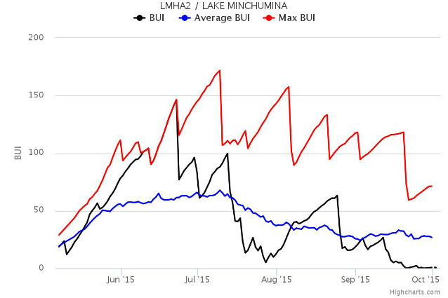
There were 16 wildfires in Denali in 2015. The second highest number of discovered wildfire in recorded history (1946 – 2015). 2015 recorded the 2nd highest number of acres burned by fires that were discovered within or outside the Park/Preserve boundary that burned into the Park/Preserve. The fire season in 2015 started off in the middle of May with indications of being a potentially extreme season with fire danger conditions very high throughout much of the Park. Approximately sixty-one thousand lighting strikes occurred statewide in a seven day period (June 19th – June 25th). Eleven of the fire in Denali started during this time period. The largest fire of the season was the Carlson Lake fire (46,545 acres) that burned across and into a number of previous years burned areas. However after the first week in July and through the remainder of the fire season regular precipitation events moderated fire growth. Two fires, that ultimately burned together and was called the Bear Creek fire, burned within 5 mile of the community of Kantishna. Unique to 2015 were the number and size of the fires near the Alaska Range. Wildfires are frequent in the lowland portions of Denali. However while vegetation types near the Alaska Range support fire growth, wildfires are relatively rare in the uplands portions of northwest Denali. Four of the 16 fires were located in the uplands portions of northwest Denali.

On numerous occasions in 2015, the Western Area Fire Management staff at Denali cooperated with the State of Alaska’s Division of Forestry, BLM Alaska Fire Service and supported multiple fires in the lower 48. Managing fires, inside and outside of the park, was accomplished by implementing the "Closest Forces" concept: NPS personnel assisted suppression actions on wildfires throughout Alaska. For example, the Fire Exclusive Use Helicopter was utilized as a reconnaissance platform and bucket operations on the Rex Complex outside of Clear, supporting the State of Alaska’s Division of Forestry, Fairbanks Area and was assigned to the Carlson Lake and Deep Creek fire complex near Lake Minchumina, supporting the Tanana Zone. Denali’s staff assisted the State of Alaska’s Division of Forestry, Mat-Su, Tok , and Southwest Area’s in support of suppressing numerous fire starts in the early spring and summer, plus sent staff multiple times with the Interagency Type 2 Hand Crew in support of fires in Alaska and the lower 48.
There were 16 wildfires and four prescribed fires in Denali in 2015.
Fire Name |
Burn Period |
Total Acres |
NPS Acres |
Fire Type |
Comments |
|
McLoed |
6/21/15-7/5/15 |
452.1 |
452.1 |
Wildfire |
Resource Management Objectives |
|
Iron |
6/21/15-7/16/15 |
4,148.5 |
4,148.5 |
Wildfire |
Resource Management Objectives |
|
Foraker River |
6/21/15-7/16/15 |
1,043.1 |
1,043.1 |
Wildfire |
Resource Management Objectives |
|
Herron |
6/22/15-7/6/15 |
903.9 |
903.9 |
Wildfire |
Resource Management Objectives |
|
Bear Creek |
6/22/15-8/14/15 |
5,774.7 |
5,774.7 |
Wildfire |
Resource and Protection Management Objectives |
|
Castle Rock |
6/24/15-7/16/15 |
323.0 |
323.0 |
Wildfire |
Resource Management Objectives |
|
Flat Creek |
6/23/15-6/25/15 |
127.9 |
127.9 |
Wildfire |
Resource Management Objectives. This fire burned together with the Bear Creek Fire on 6/25/15. |
|
Bear Paw |
6/25/15-8/6/15 |
39.8 |
39.8 |
Wildfire |
Resource Management Objectives |
|
Chilchukabena |
6/25/15- 7/29/15 |
361.3 |
361.3 |
Wildfire |
Resource Management Objectives |
|
Moose Creek |
6/25/15-8/20/15 |
2,856.4 |
2,856.4 |
Wildfire |
Resource and Protection Management Objectives |
|
Carlson Lake |
6/25/15-9/29/15 |
46,545.3 |
46,545.3 |
Wildfire |
Resource and Protection Management Objectives |
|
Lonestar |
6/25/15-7/23/15 |
6,940.5 |
2,003.6 |
Wildfire |
Resource and Protection Management Objectives. This fire burned together with the Munsatli 2 fire on 7/23/15. |
|
Munsatli 2 |
7/4/15-9/29/15 |
1,309.5 |
100,524.0 |
Wildfire |
Resource and Protection Management Objectives. This fire burned together with the Munsatli and Lonestar fires on 7/23/15. |
|
Foraker |
7/6/15-8/25/15 |
1,949.4 |
1,949.4 |
Wildfire |
Resource Management Objectives |
|
Diamond |
7/23/15-8/2/15 |
20.9 |
20.9 |
Wildfire |
Resource Management Objectives |
|
Castle 2 |
7/29/15-7/29/2015 |
5.4 |
5.4 |
Wildfire |
Natural out |
|
FY 2015 Admin Rd 1 RX Burn |
3/17/15-3/19/15 |
1.57 |
1.57 |
Prescribed fire* |
Burning of biomass debris from roadside maintenance projects and hazard fuels treatment projects |
|
FY 2015 Toklat Pile RX Burn |
9/23/15-9/24/15 |
0.52 |
0.52 |
Prescribed fire* |
Burning of biomass debris from roadside maintenance projects and hazard fuels treatment projects |
|
Gallop Cabin Pile RX Burn (DENA-236) |
9/23/15-9/24/15 |
1.2 |
1.2 |
Prescribed fire* |
Burning of biomass debris from roadside maintenance projects and hazard fuels treatment projects |
|
Eldorado Creek Reclamation RX Burn |
9/23/15-9/24/15 |
1 |
1 |
Prescribed fire* |
Burning of biomass debris from restoration work associated with the Eldorado Creek reroute project. |
*Prescribed fire is a fire ignited by management actions under certain, predetermined conditions to meet specific objectives related to hazardous fuels or habitat improvement. Prior to a prescribed fire, a written, approved prescribed fire plan must exist and NEPA requirements must be met.
Prescribed Fires Planned for 2016
Piles of cut vegetation or woody debris are sometimes created during a hazard fuels reduction project. These piles need to be burned in order to complete the firewise treatment for these sites. During 2016, staff plan to burn debris from past hazard fuels projects at the Headquarters, Toklat, Moose Creek Patrol Cabin and Stampede Mine.
Fire Name |
Fire Date |
Acres |
Fire Type |
Comments |
|
FY 2016 Admin Rd 1 RX Burn |
3/17/15-3/19/15 |
2.42 |
Prescribed Fire |
Burn biomass debris from roadside maintenance projects and hazard fuels treatment projects. |
|
Toklat Pile RX Burn |
2016 |
6.6 |
Prescribed Fire |
Burn biomass debris from roadside maintenance projects and hazard fuels treatment projects. |
|
Stampede Mine |
2016 |
4.55 |
Prescribed Fire |
Burn biomass debris from hazard fuels treatment projects. |
Optional |
||||
|
Moose Creek Patrol Cabin |
2016 |
.86 |
Prescribed Fire |
Burn biomass debris from hazard fuels treatment projects. |
|
Kantishna RX Burn |
2016 |
2.03 |
Prescribed Fire |
Burn biomass debris from hazard fuels treatment prjects. |
|
Glen Creek Debris |
2016 |
|
Prescribed Fire |
Burn burnable debris from reclamation project. |
|
Eldorado Creek Reclamation RX Burn 2 |
2016 |
1.0 |
Prescribed Fire |
Burn burnable debris from reclamation project. |

Fire Ecology Projects Planned for 2016
Plans for the 2016 season include the continuation of fuel moisture monitoring at the Denali Visitors Center RAWS station, completion of the Denali Hazard Fuels Monitoring report, and the initiating a joint NPS/USGS project to ascertain the post fire effects of wildfires burning vegetation multiple times over short time intervals and the vegetation, environmental and fuel moisture factors that are contributing to shortened fire return intervals.
Fire Education
- Western Area Fire Management, the Regional Fire Communication and Education Specialist, and MSLC staff will continue to incorporate wildland fire management messages in select presentations.
- The Alaska Western Area fire staff will seek to promote the revised Alaska FIREWISE concept in 2015 and assist with Firewise workshops that teach community members how to reduce the combustible material around their homes to reduce the risk of wildland fire.
- Each year Fire Management staff provides updated maps and information about fires in and outside of the park. Fire danger information is also updated and posted at various locations. Three fact sheets are available—Wildland Fire Risk and Response: Why are you cutting those trees?, Where is all that smoke coming from?, and Wildland Fire Ecology
Last updated: July 29, 2016
