NPS Photo / Brad Ebel
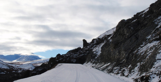
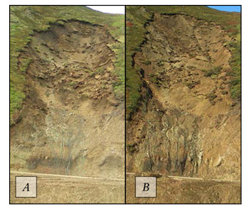
Following the October 23rd, 2013 discovery of the initial ~600’x110’, ~30,000 cubic yard, debris slide which covered the park road near mile 38 above Igloo Creek (further referred to as the Igloo Debris Slide), park geoscientists have continued to monitor and study the area. Site monitoring, including timelapse photography, reveals continued activity and evolution of the scarp throughout the summer of 2014, often associated with rapid, high intensity, precipitation events. Only a small amount of material ever reached the park road and none of these motions posed a direct hazard to visitors. However, occasional larger events may be contributing to the loading of a sizeable mass of material within the central portion of the scarp that, if it failed, has the potential to release material onto the road. Study of the Igloo Debris Slide highlights the dynamic nature of the Earth in Denali, but also the concerns associated with natural hazards.

Monitoring an Active Landslide
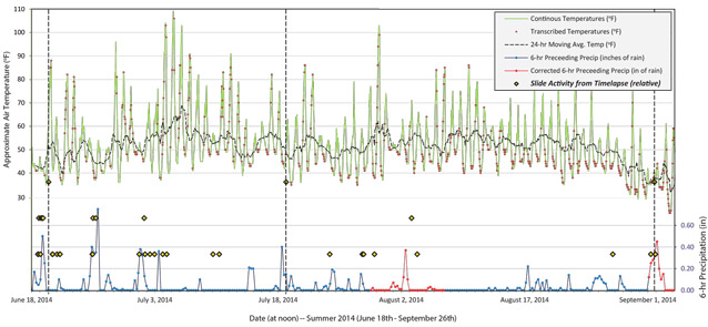
We employed the use of time-lapse photography, precipitation and temperature instruments, in addition to various GPS and remote sensing techniques to record landslide activity and associated environmental variables. Continuous time-lapse photography allows us to accurately time the initiation and duration of events, visually estimate the volume of events, and a record of the type of motion occurring. Comparison of photos allows us to see the evolution of the footprint and character of the scarp through time. We use GPS and remote sensing methods to more accurately quantify the amount of material being displaced within the scarp over longer durations. Patterns or changes in these data give us important information about what environmental conditions affect slide activity the most, if the type of activity is changing, and if activity is accelerating or decreasing over time.

Igloo Debris Slide Activity During 2014
During the monitoring period from June through September, photo comparison and remote sensing reveal an overall retreat of the scarp accompanied by an overall reduction in slope. Although the time-lapse footage shows abundant, low volume, shallow, soil slumps, the majority of the material displaced during the monitoring period occurred during large precipitation events that displaced several hundred cubic meters of material each. Isolating the triggers associated with larger events helps us determine under what conditions the Igloo Debris Slide is most active and poses the most potential risk to visitors.
Understanding Landslide Activity
Variables such as earth materials and slope angle can vary within a given slope, but tend to be relatively fixed in time and do not typically cause a slope hovering near the stability threshold to move back and forth across that line. Rather, increased pressure from fluids within the hill slope from rapid or prolonged precipitation, or thawing permafrost as the temperature spikes, are likely to cause acute failures. The results of our monitoring demonstrate that increased slide activity correlates best with high intensity rainfall. Landslide activity does not correlate well with air temperature shifts. We are still investigating the influence of prolonged rainfall and saturation of the hillslope, and the possible longer term effects of thawing permafrost as the scarp matures.
Mitigation and Future Work
None of the events recorded during 2014 would have posed a direct hazard to anyone present along the park road. However, because all active landslides have the potential for future instability, the park is working to determine potential risk to visitors and mitigate it effectively. The park currently places “no stopping” signs in the area of immediate concern, has a dug a small catch basin below the scarp, and is actively engaged with experts at the National Park Service-Geologic Resources Division to monitor the changing risk to individuals traveling past this point. We will continue to monitor the Igloo Debris Slide during the summer of 2015, and plan to incorporate additional temperature probing as a method of assessing the potential for increased scarp degradation resultant from thawing permafrost. All of these efforts are meant to keep visitors to the park safe as they enjoy the dynamic Earth that Denali National Park and Preserve showcases.
Last updated: February 17, 2016


