NPS Photo
Shrinking glaciers, permafrost thaw, changing patterns of wildlife and vegetation, and dry conditions in Central Alaska and Denali National Park and Preserve have all been attributed to warming temperatures over the past few decades. Scientists and park managers would like to predict future impacts from climate change and determine if the current warming trend is a long-term or shortterm event. Because water has a significant influence on impacts from a changing climate, scientists are also trying to understand changes in precipitation.
Unfortunately, most climate records based on instrumentation (e.g. weather station data), which extend less than 50-100 years into the past, provide a relatively short time window to see patterns of climate change for comparison to current trends. For this reason, scientists rely on climate proxies—natural records that are stand-ins for long-term weather patterns. In addition to such things as tree rings, corals, and lake sediments, ice cores from glaciers are an excellent proxy for long-term climate records. Glacier ice can preserve past atmospheric chemistry, which can be related to past climate conditions.
Requirements for Selecting Glacier Ice Core Sites
Glaciers form through year-after-year snow accumulation with minimal melting. Each snowfall event piles onto the previous layers, similar to a stack of pancakes. In the stack, the oldest layer is on the bottom and the most recently deposited layer is on the top. Eventually, the compressed, deep snow condenses to form ice and the ice will begin flowing very slowly downhill as a result of gravity. The perfect ice core site would be in glacial ice that has experienced minimal melt or flow since the snow (now ice) was originally deposited. Ice melt and flow have the potential to alter the key components of ice which are useful as climate proxies—chemistry and layering.
Glacial basins, flat plateaus, or ice divides located at high elevations present the most ideal ice core sites because these regions are generally too cold for melting to occur and the ice is generally frozen to the bedrock so it experiences very little flow or deformation from its original state of deposition. In addition, the ideal ice core site must capture many years of accumulated chemical data in the depth of ice. At sites where there are low snow accumulation rates and high total ice depths, a deep ice core captures many years of proxy climate data. Glaciers cover 17 percent of the park, making it a prime location for finding an ideal ice core site. The high elevation and northern latitude of the Alaska Range also assures minimal melting and slow ice flow rates due to the cold temperatures.
Teaming Up to Find Potential Ice Core Sites
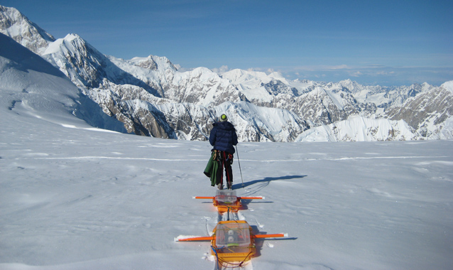
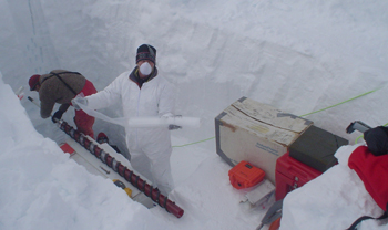
A collaborative research team from the University of Maine (Dr. Karl Kreutz and Seth Campbell), Dartmouth College (Dr. Erich Osterberg), and the University of New Hampshire (Dr. Cameron Wake) has been searching for potential ice core drill sites in the Alaska Range. The team has conducted reconnaissance for ice core drill sites on glaciers on three different mountains, using a multi-disciplinary approach of GPS systems; ice-penetrating radar; and chemical analysis of snow samples from snow pits and shallow hand-drilled ice cores.
Mount Russell (Yentna Glacier)
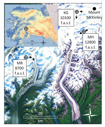
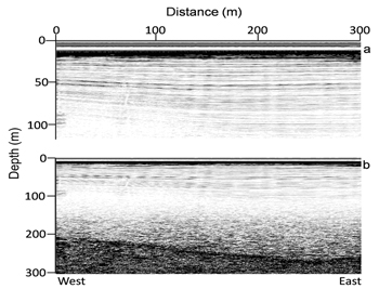
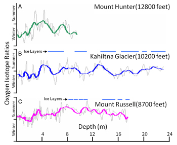
Researchers studied one site at the base of Mount Russell at the southwest edge of Denali’s “old park” Wilderness. Of the three potential sites studied in Denali, this site is the lowest elevation—the highest point on the glacier is 2652 m (~8,700 feet) above sea level (asl). An ice core measuring 24 m (78 feet) long was drilled from the Yentna Glacier. The core showed extremely high accumulation rates and the layering and chemistry signals within the ice suggest that a significant amount of melt occurs at this elevation. Using radar to measure the depth of ice over bedrock, researchers discovered 200 m (600 feet) of ice. With the high accumulation rates, there would likely be a maximum of 270 years of ice chemistry saved within this glacier.
NPS Photo
Kahiltna Glacier, Mount McKinley
The Kahiltna Glacier, on the southern flank of Mount McKinley, covers one of the greatest elevation transects of any mountain glacier in the world. The research team collected measurements about the glacier’s ice depth, layering, and surface ice flow velocities at a site between 3100 to 3900 m (10,170 to 12,800 feet). The results suggest that the ice on the upper Kahiltna Glacier has experienced significant deformation caused by ice flow and avalanche debris from up-glacier events intermixing with the flat-lying snow. The team also collected shallow ice cores that show some melting at this site causing some chemistry redistribution within the ice.
Mount Hunter (Ice Divide)
The final site studied by researchers is located between the north and south peaks of Mount Hunter at 3910 m (12,800 feet). From shallow ice cores and snow pits, researchers noted minimal melting and a low accumulation rate (0.31 meters or about one foot per year) at this site. Radar data show nearly flat internal ice layering suggesting no deformation from flow, and maximum ice depths over 250 meters (750 feet). Based on these data, climate proxy records for more than 4800 years likely exist in the deepest region of the Mount Hunter basin. Thus, the team of scientists considers this site the best potential ice core drill site yet located in the Alaska Range.
What’s Next?
The team of scientists are proposing research to extract a full-length surface-to-bedrock ice core from the deepest region of the ice divide on Mount Hunter. If the climate record from this ice core extends over 4000 years, it will provide one of the highest resolution long-term climate proxies in North America. Researchers would use chemistry data from this deep ice core to estimate regional past temperatures, precipitation rates, and atmospheric circulation patterns over the duration of the record. This information will help estimate future effects of climate change in the Alaska Range.
Last updated: April 22, 2016


