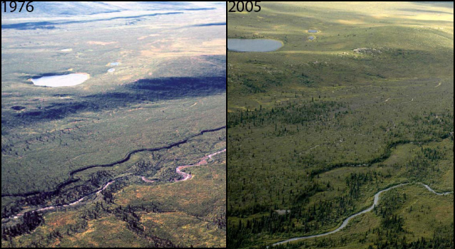
Photos by Fred Dean (left), Carl Roland (right)
The vast landscapes of interior Alaska are changing. Large glaciers are melting and receding up valleys. Ancient permafrost is degrading and turning frozen soils into soupy gelatin. Woody vegetation is spreading into open areas. Boreal ponds and wetlands are shrinking. Climate data for interior Alaska show a clear warming trend over the past several decades. A growing scientific consensus suggests that this tide of warming is bringing changes to Alaska’s ecosystems. While what will happen to these ecosystems is unknown, it is certain that the changes have profound consequences for life in the north.
Using Historical Photographs
In 2005, the Central Alaska Network (CAKN) received a serendipitous gift of several hundred 35-mm slides. They were photographed from the backseat of a two-seater airplane in 1976. The donor, Dr. Fred Dean (professor emeritus of wildlife biology at the University of Alaska, Fairbanks) and his graduate student, Debbie Heebner, used these photographs to help produce the first land cover map of what was then Mt. McKinley National Park.
Soon after receiving the photographs, park staff scanned the slides at high-resolution and studied their locations. They used print copies of the photographs and location maps to repeat the original photographs from the air. Now analyzed, these photo pairs offer a treasure trove of information about visible vegetation changes over the last several decades. Researchers took notice of the value of these early photographs, and have dug deep in museum collections and historical archives to find more images worth repeating.
The repeat photo pairs provide dramatic visual evidence of recent vegetation changes. The size of the observed changes in the photo pairs surprised researchers.
The primary types of changes were:
- Expansion of spruce into formerly treeless areas
- Invasion of open wetland areas by woody vegetation
- Widespread colonization of formerly open floodplains and terraces by vegetation.
Often, these changes were not simply a shift in vegetation due to succession, but were the replacement of one vegetation type by another. Over the past 30 years many such examples appear to have changed park landscapes.

Monitoring Landscape-scale Change
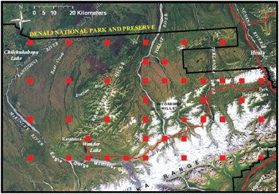
Understanding these changes requires more rigorous and detailed information than is available in photographs. To gather the necessary data, the CAKN Inventory and Monitoring Program is implementing intensive, landscape-scale monitoring of vegetation across the three parks in the network (Denali National Park and Preserve, Yukon-Charley Rivers National Preserve, and Wrangell-St. Elias National Park and Preserve).
Monitoring began in Denali and Yukon-Charley Rivers in 2006, and Wrangell-St. Elias in 2007. The goals of the vegetation monitoring are to detect and quantify vegetation changes like those captured by repeat photography, and to document the magnitude (dimensions) and ecological consequences of these changes using reproducible, statistically rigorous protocols.
Carl Roland, Denali’s botanist, led CAKN in establishing a sampling design based on a systematic grid. Changes can be detected at multiple spatial scales from individual sample plots to across-park landscapes.
At each plot, ecologists measure and record the types and abundances of vascular plants (flowering plants, conifers, ferns, and fern-allies), mosses, and lichens; dimensions and locations of all trees; and physical attributes, including soil properties. Ecologists also collect cores from trees just outside the permanent plots and mark each plot’s center with a monument.
To detect long-term trends in the vegetation cover at both small (the plot) and large (landscape) scales, ecologists will resample each plot on an approximately decadal rotation schedule.
Patterns of Vegetation on the Landscape
Over 1000 permanent vegetation plots have been installed so far in Denali, and over 750 in Yukon-Charley Rivers. From data collected at these plots, ecologists are learning a great deal about vegetation-landscape relationships and the distribution and diversity of plants across the landscape. For example, across all spatial scales, the average species richness of plant communities rises with increasing elevation (highest in the high alpine zone of the park).
Alpine areas not only support plant communities of high species richness, these areas also claim hold to the greatest diversity of rare and endemic plants. These vegetation patterns signal an early warning of potential threats to plant conservation. With continued warming, woody vegetation will increasingly invade alpine tundra, thereby displacing these highly diverse plant
Management Response to Changes in Vegetation
In interior Alaska, the landscapes are dramatically changing. Both the comparison of then-and-now repeat photography and data from multi-scale vegetation monitoring are important parts of a comprehensive monitoring program that should allow detection, understanding, and potential management of vegetation change into the future.
More Information
Dig into this web catalogue of over 200 repeat photographs (multiple photos taken of a single location at different times) to visualize the landscape changes occurring throughout many regions of the subarctic. Descriptions of change (or lack of change) documented in each photo pair will guide your exploration of the shifting nature of Denali National Park and Preserve, and fine-tune your eye to reading the landscape wherever you may be.
Last updated: January 12, 2017
