During the past two million years, Denali’s history has been characterized by repeated advances and retreats of a massive ice sheet .... Landforms such as sculpted valleys, terraces, moraines, and kettle ponds are common in the northern river valleys
NPS Photo / Katie Thoresen
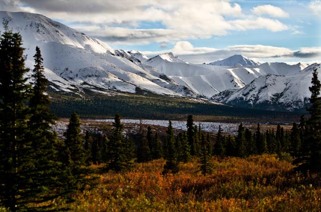
The landscapes of Denali National Park and Preserve (Denali) are a legacy of the region’s geological history and the advance and retreat of glaciers. One of the major influences on Denali’s ecosystems is the Alaska Range, the massive wall of rock, glacial ice, and snow running from southwest to northeast across the park’s six million acres (2.4 million hectares). It towers above and separates the Kuskokwim and Tanana river basins to the north and from the Susitna River lowlands to the south (Figure 1). This mountain barrier creates two major climate zones in the park and dramatic elevation differences. As a result, the ecosystems range from lowlands with taiga forests, braided glacial stream floodplains, and meandering sloughs; to subalpine woodlands, meadows, and scrub tundra; to alpine low-shrub tundra slopes and steep peaks, including Mount McKinley at 20,310 feet (6,194 m).
Geologic History
The oldest rocks in the park, collectively called the Yukon-Tanana terrane, were ocean sediments deposited in shallow seas during the Paleozoic era some 300 to 500 million years ago. Later in the Paleozoic and into the Early Mesozoic (100 to 300 million years ago), other terranes, fragments of the larger continental plates, migrated north on the Pacific Plate and attached to the Yukon-Tanana terrane, creating the current jigsaw puzzle of rocks from many depositional environments.
During the last 100 million years, the assembled terranes buckled from continuous tectonic collision, uplifting to create the present-day topography of the Alaska Range. About six million years ago, a regional uplift that began in the Alaska Range spread north to push up the Outer Range (Mts. Healy, Margaret, and Wright)(Fitzgerald et al. 1993).
Around 70 million years ago, alternating warm, near-tropical conditions and cooler, drier periods enhanced erosion and deposition in sedimentary basins such as the Cantwell, where dinosaurs walked among ancestral lakes, braided streams, and alluvial fans. Volcanic eruptions dominated the scene 40 to 50 million years ago, creating the colorful rocks at Polychrome Pass. Subsurface magma cooled to become the granitic bulk of Mounts McKinley and Foraker (Cole 1999).
Because the Pacific Plate continues to collide with and slide beneath Alaska, the buckling and uplift continues, creating a seismically active area around Denali. Generally following the Alaska Range, the Denali fault system extends for about 750 miles (1200 km). In November of 2002, the magnitude 7.9 earthquake centered on the Denali fault east of the park ruptured the surface with up to 30 feet (9 m) of strike-slip offset. Seismic events of similar magnitude may occur in the park in the future.
Glacial History
During the past two million years, Denali’s history has been characterized by repeated advances and retreats of a massive ice sheet. Over half of the park (Alaska Range and south) was intermittently covered by an extension of the ice sheet in Canada (Figure 2). During glacial maxima, valley glaciers dominated the northern foothills of the Alaska Range, and ice lobes extended into the lowlands. As many as seven major glacial advances and several minor advance-retreat sequences have been identified on the north side of the range (Thorson 1986). Landforms such as sculpted valleys, terraces, moraines, and kettle ponds are common in the northern river valleys.
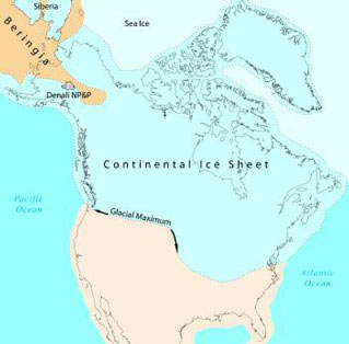
During these Pleistocene glaciations, the northern area of the park was part of Beringia—a vast ice-free refuge for plants and animals, connected to northeastern Asia by the Bering Land Bridge, and isolated from the rest of North America by the ice sheet. These areas in Denali were probably colder and much drier than the present climate. Trees were essentially absent, and the vegetation was more tundra-like than today. Because of this history of repeated land connections to northern Eurasia with isolation from the rest of North America, there is a high degree of similarity of animals and plants between interior Alaska and north Asia.
Glacial ice has retreated significantly since the Pleistocene. Today, only about 16% of the park is covered by ice or perennial snow fields. However, glaciers continue to have a cooling effect near their termini and downstream. Glacial meltwaters affect local weather conditions and reconfigure floodplains downstream. Glacial action has been a major factor in breaking down rocks to produce the soils on which Denali’s ecosystems depend (Clark and Duffy 2004).
Climate
There are two distinct climates in the park, separated by the Alaska Range. They differ not only in physical measurements, but also in the types of vegetation and landscape features they produce. South of the range, maritime air masses moderate air temperatures and bring considerable rain and snow. On the north side, an area of Arctic high pressure generates continental climate conditions with high variations in temperature and low precipitation.
At park headquarters (north of the Alaska Range), daily weather observations have been recorded since 1925. Temperature extremes range from 91°F (33°C) to -54°F (-48°C). Summers are short and warm, and winters are long and cold. The average daily high temperature in July is 66°F (19°C), and the average daily low temperature in January is -8°F (-22°C). Total precipitation is relatively low at 15 inches (382 mm). The sub-zero temperatures in winter coupled with relatively low snowfall contribute to the presence of widespread permafrost.
The climate south of the range is transitional between the mild and moist condi-tions near the Gulf of Alaska and the cold and dry of Interior Alaska. The mean annual precipitation at Talkeetna, southeast of the park border, is 28 inches (711 mm), nearly double that at headquarters. The average daily high temperature in July is 68°F (20°C), and the average daily low temperature in January is 1.4°F (-17°C). Along the southern flanks of the Alaska Range, snowfall is high, and snowcover is often present through late spring. Permafrost is generally absent.
Natural Disturbance
The local ecosystems are shaped by the physical environment (geology, glaciers, climate). Interactions among these factors and the habitat preferences of plants create the mosaic of vegetation on the landscape. For example, stunted scattered spruce in northern areas of the park grow over permafrost, while more lush vegetation is supported on permafrost-free areas. In addition, natural disturbances such as earth movements, fire, and water flow alter the local landscape patterns.
NPS Photo / Yaz Matsui
The major processes on the landscape vary across ecological zones. Geomorphic disturbances such as landslides, avalanches, and other mass movements predominate in the alpine region. Freeze-thaw conditions, especially in the active layer above permafrost, often create landform features such as slumps, gelifluction (creeping soil lobes), frost heaves, hummocks, and ice-wedge polygons. Thermokarst features (ground subsidence from melting permafrost) are found in isolated plateaus in the northeast portion of the park.
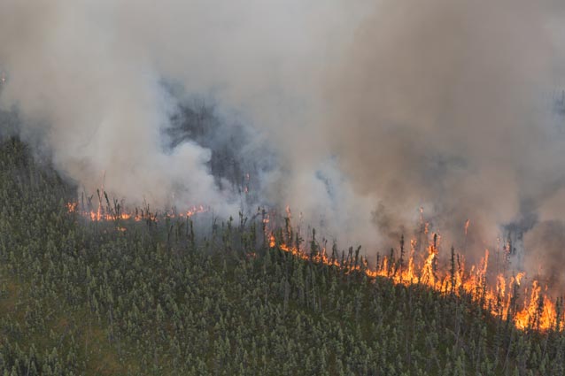
Fire plays a dominant role in modifying the lowlands (Figure 3), particularly in the basins north of the Alaska Range that are characterized by low precipitation and hot summers. The action of flowing water is another important natural disturbance process in boreal lowlands. Large braided glacial rivers such as the McKinley, Toklat, Yentna, and Chulitna are constantly reshaping the land by shifting channels, creating new floodplain deposits, and eroding old terraces with established forests. Beavers also have a considerable influence on the distribution of wetlands by impounding streams, especially in forested lowlands of the Yentna, Susitna, Kantishna, and Kuskokwim river basins.
Cultural Influencs
Humans have been present in the Denali area for at least 11,000 years, but the park represents a rare place where human influence has never fundamentally altered the natural ecosystems. From the end of the last ice age until roughly 100 years ago, the upland areas were occupied seasonally by bands of hunters and gatherers who lived the rest of the year in forested areas near the larger rivers.
Because none of the large navigable rivers flowed near the high Alaska Range, the area that was to become the park was among the last parts of Alaska to be explored by non-natives. Explorers, prospectors, and trappers trickled into the area in the 1890s, and a series of gold strikes between 1903 and 1906 briefly brought large numbers of miners into the Kantishna area.
Concern about market hunting in the game-rich Alaska Range foothills was one of the driving forces that led to the creation of Mount McKinley National Park in 1917 (Brown 1993). The Alaska Railroad was completed through Broad Pass and the Nenana Valley in 1923, providing tourist access to the park, and the park road to Kantishna was completed by 1938. Since 1972, visitors have had easy access to the park by way of the George Parks Highway between Anchorage and Fairbanks. Today, roughly 450,000 people visit the park yearly.
Ecology of Plants and Wildlife
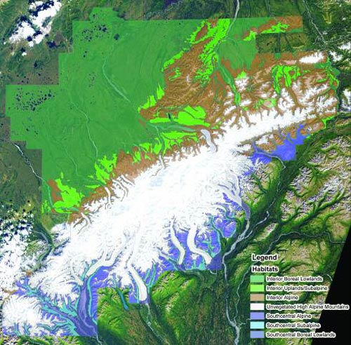
Denali is located in the northern boreal forest biome (Figure 6). The landscape is predominantly forested at elevations less than 2,500 feet (760 m), with scrub vegetation and spruce woodland in the subalpine zone (2,500 to 3,500 feet, 760 to 1070 m) and low tundra in the alpine zone (above 3,500 feet, 1070 m). Limits of local treeline and the subalpine and alpine zones depend on topography, site history, and local variations in climate.
Currently, there are 39 species of mammals and 165 species of birds documented in Denali, along with one amphibian (the wood frog), and 15 species of fish. More than 750 species of vascular plants grace the landscape, along with approximately an equal number of nonvascular plant species (mosses, lichens and liverworts) (MacCluskie and Oakley 2004, Roland 2004).
Many birds that breed in Denali migrate long distances to reach the park, some from as far away as South America, Asia, and Africa. Great numbers of sandhill cranes and trumpeter swans create a stirring sight as they migrate in skeins above Denali.
Each year, king, silver, and chum salmon migrate more than 1,000 miles (1,600 km) from the Bering Sea to spawn and die in Denali’s rivers, providing an important food source for many mammals and birds.
Boreal Lowlands
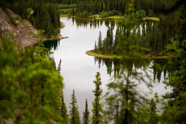
Denali’s lowland zone includes black spruce forests and woodlands in areas underlain by permafrost and white spruce and paper birch forests in well-drained upland areas and river corridors (Figure 5). Forests have become established in the last 6,500 years, after the last glacial retreat, but probably also existed during earlier inter-glacial periods. Recently disturbed and warmer south-facing slopes support stands of trembling aspen and balsam poplar. River bars support early successional herbs scattered among groves of balsam poplar, aspen, and spruce.
NPS Photo
Shrubs that grow slowly in the cold soils of black spruce forests include alder, dwarf birch, Labrador tea, shrub cinquefoil, several species of willow, and blueberry. Black spruce stands burn periodically, so trees seldom reach ages beyond 120 years. Common shrubs in the more nutrient-rich spruce-birch forests are dwarf birch, rose, willows, and high-bush cranberry.
Interspersed in the forested areas are dry, open sites, wetlands and kettle-hole ponds. Dry sites often include a tangle of kinnikinnik, rose, and soapberry. The warmest, driest sites on the north side of the Alaska Range are dry meadows of grasses, sagebrush, juniper shrubs, and herbaceous perennials. Equivalent slopes on the south side can be lush meadows of grasses, lupine, geranium, and cow parsnip because even the dry slopes have more moisture. The wetland and riparian areas support sedges, rushes, grasses, forbs, and mosses.
An assortment of resident and migratory birds lives in the lowland forests including northern goshawk, great-horned owl, boreal owl, woodpeckers, black-capped and boreal chickadees, ruby-crowned kinglet, yellow-rumped warbler, and white-winged crossbill. Wetlands are nesting grounds for sandhill cranes, trumpeter swans, common loons, many species of waterfowl, arctic tern, northern water-thrush, and rusty blackbirds.
The most noticeable mammal in spruce forests is often the red squirrel, due to that species’ high numbers, bold behavior, and daytime activity. But many other species with more secretive lifestyles, including voles, lemmings, shrews, snowshoe hares, and flying squirrels, are also common in the taiga forest. These small mammals provide the food base for a variety of medium-sized predators, including lynx, marten, and red foxes. Several species of large mammals live at low densities throughout the lowland areas but are more common in higher ele-vation areas. These include moose, wolves, caribou, and grizzly bears. The black bear is the only large mammal species that is more common in the lowland areas of the park than in the higher elevations.
Subalpine
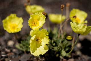
In the subalpine zone, there is a mosaic of scrub vegetation (dwarf birch, alder, and willow), open spruce woodland, and meadow (see photo page 6). Near treeline, the land cover shifts from open woodland to tundra shrubs (willow, blueberry, dwarf birch, rhododendron), dwarf shrubs (bearberry, mountain avens, crowberry, and netted willow), grasses, and annual plants.
Bird denizens of this zone include willow ptarmigan, northern harrier, merlin, upland sandpiper, northern hawk-owl, arctic warbler, olive-sided flycatcher, gray-cheeked and Swainson’s thrushes, fox sparrow, golden-crowned sparrow, black-poll warbler, and orange-crowned warbler.
NPS Photo
Where snowmelt is late, as on north-facing slopes, the alpine zone also includes spring beauty, mountain heather, mountain sorrel, and buttercups. In sunny but moist areas, the vegetation is a mixture of dwarf shrubs and sedges. On windswept ridges, lichens add to the relatively sparse cover of mountain avens and grasses. Dry sites can be variable (from scattered grasses to complete plant cover) depending on the growing conditions, but harbor some of the rarer plants, including many species with evolutionary roots in the Beringian tundra and ultimately in Asia.
A diverse community of open-landscape birds lives in the alpine region including golden eagle, gyrfalcon, white-tailed ptarmigan, American golden-plover, surfbird, long-tailed jaeger, horned lark, northern wheatear, and gray-crowned rosy finch.
Dall sheep are among the most obvious and spectacular residents of the alpine habitats. Other large mammals, including wolves, caribou, and grizzly bears, spend much of their time in the alpine zone. Pikas and hoary marmots are two of the park’s mammal species that live only in alpine areas.
Unvegetated High Alpine
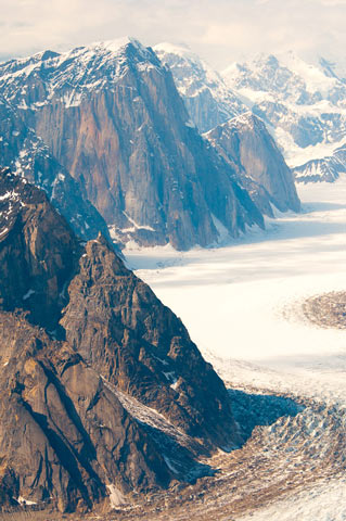
Nearly one-third of the park is made up of high, glaciated mountains and bare rock outcrops (Figure 9). The upper limit of plant growth is about 7,500 feet (2290 m). Above 8,000 feet (2440 m), alpine areas are generally covered by glacial ice. Only scattered traces of vegetation occur there, mostly lichens on isolated patches of bare rock.
NPS Photo / Kent Miller
No birds or mammals make their homes in these barren reaches, but wolverines, wolves, and caribou occasionally negotiate high mountain passes, ravens and redpolls are seen at very high elevations, and many species of birds migrate over the mountains. More than 1,000 humans annually attempt to climb Mount McKinley during the spring and early summer climbing season, but for most of the year and for most of the area, the mountains and icefields are nearly devoid of life.
The Future
Despite being a wilderness park, Denali faces threats from human activity on many scales, including increased tourism and development, introduction of exotic species, increased hunting pressures, and accumulation of trace amounts of global airborne contaminants. The retreat of glaciers and changes in vegetation due to climate change are easily seen in photographs taken only decades apart. These influences and their effects are difficult to measure, but they may dramatically alter the distribution and visibility of wildlife. Park management faces an increasing challenge to protect resources in the face of climate change and other human effects.
References
Brown, W.E. 1993.
Denali: Symbol of the Alaskan wild. An illustrated history of the Denali-Mount McKinley region, Alaska. The Donning Company. Virginia Beach, VA.
Clark, M.H., and M.S. Duffy. 2004.
Soil Survey of Denali National Park and Preserve Area, Alaska. USDI-NPS
Cole, R.B. 1999.
Co-magmatic ties between the Cantwell volcanics and McKinley sequence plutons: Constraint on the early Tertiary offset history of the McKinley fault, central Alaska Range. Geological Society of America Abstract Programs, 31, 46.
Forbes, R.B., T.E. Smith, and D.L. Turner. 1974.
Comparative petrology and structure of the McKlaren, Ruby Range, and Coast Range belts: Implications for offset along the Denali fault system. Geological Society of America Abstract Programs (Cordilleran Section), Vol. 6(3):177.
Fitzgerald, P.G., E. Stump, and T.F. Redfield. 1993.
Late Cenozoic Uplift of Denali and its Relation to Relative Plate Motion and Fault Morphology. Science 259:497-499.
MacCluskie, M., and K. Oakley. 2004.
Central Alaska Network Phase III monitoring plan draft report. National Park Service. Fairbanks, Alaska.
Roland, C.A. 2004.
The vascular plant floristics of Denali National Park and Preserve. National Park Service, Central Alaska Network Inventory and Monitoring Program. NPS Final Technical Report CAKN-04-01.
Thorson, R.M. 1986.
Late Cenozoic Glaciation of the Northern Nenana Valley. In Glaciation in Alaska: The Geologic Record, by Hamilton, Reed, and Thorson. Alaska Geologic Society.
Part of a series of articles titled Alaska Park Science - Volume 5 Issue 1: Scientific Studies in Denali.
Last updated: March 16, 2015
