On August 7, 2011, a tanker laden with fuel oil crashed into the rocky reefs of Little Diomede Island in the Bering Strait in Northwest Alaska, spilling 400,000 of gallons of IFO 180 fuel oil (a type of intermediate fuel oil) adjacent to Bering Land Bridge National Preserve. This was the scenario for a planning exercise in late 2011 sponsored by the U.S. Coast Guard (USCG) and supported by the State of Alaska Department of Environmental Conservation (ADEC) and National Oceanic and Atmospheric Administration (NOAA) Office of Restoration and Response (ORR) to understand the potential ecological impacts from a spill in the Bering Strait region of Northwest Alaska (Aurand and Essex 2012).
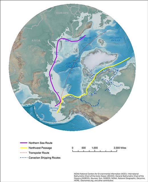
With continued sea ice extent reductions, the Bering Strait is poised to become a crucial marine transport waterway for the world. Connecting the Bering Sea to the Chukchi Sea, the Bering Strait is the only marine connection from the Pacific Ocean into Arctic waters; thus, all Pacific marine traffic to or from the Arctic Ocean must pass through the Bering Strait (Figure 2). Because of continuing reductions in summer Arctic sea ice extent from historical averages, the northern passage shipping routes (the Northern Sea Route above Siberia and the Northwest Passage through the Canadian Archipelago) are now in use or proposed for use by cargo ships, fuel tankers, tourism vessels, and others (Figure 3). Using the Northern Sea Route reduces both transit time and distance to Europe and North America from Asia compared to some Suez and Panama Canal routes. The Northwest Passage is still too ice-choked for commercial routes and is infrequently used, but shipping traffic is likely to increase as ice continues to withdraw. Daily traffic rates through the Bering Strait are projected to increase by as much as 500 percent by 2025 (Azzara et al. 2015). The increasing maritime importance of the Bering Strait is expected to outpace infrastructure development to protect this coastal region (US CMTS 2013).
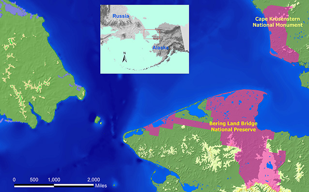
Arctic shipping transits through the Bering Strait are immediately adjacent to the western Arctic parks of Bering Land Bridge National Preserve and Cape Krusenstern National Monument (Figures 3 and 4). Significant concerns from the increasing risk of spills and vessel incidents have made preparing for a coastal incident one of the highest priorities for park management of both parks. Reductions in sea ice leave the northern sea routes open to vessel traffic later into the fall, increasing shipping vulnerability due to several factors including late fall storms. Marine transportation is increasing along northern shipping lanes to support oil development and exploration, industrial development and expansion, and growing communities in northern Alaska (US CMTS 2013).
Fuel is transported by fuel barges navigating and anchoring in shallow waters near shore. The Red Dog Mine uses a port site located on Native Corporation lands surrounded by monument lands and currently barges in over 20 million gallons of diesel fuel per year along the coast, and plans to operate for 50 more years.
The western Arctic region is extremely remote with only eight coastal villages between Nome and Kivalina, an extent of over 750 coastal miles (1,207 kilometers). Comparatively, a similar coastal extent along the Gulf of Mexico coast stretches from Panama City, Florida, to Marsh Island, Louisiana, and includes New Orleans, Mobile, Gulfport, Biloxi, and Pensacola. In Alaska, the nearest Coast Guard vessel station is on Kodiak Island (1,400 miles [2,253 kilometers] away by sea) and the nearest Coast Guard aircraft station is in Anchorage (650 miles [1,046 kilometers] by air). The scenario of a Bering Strait incident, with Coast Guard vessels in home port, is roughly akin to a shipwreck occurring in Portland, Maine, and the Coast Guard sending a plane from Raleigh, North Carolina to assess, and using a vessel from Miami, Florida, to respond.
Fortunately, the key industrial stakeholders have some response capability in place partnering with Alaska Chaddux, a response consortium that provides rapid, early response. Alaska Chaddux participated in spill response workshops in Kotzebue and Nome this year and reported that they now have response equipment staged at the Ted Stevens Anchorage International Airport that can be deployed by a C130 aircraft statewide immediately following a spill. Chaddux is a nonprofit, member-driven spill-response organization whose members include many of the fuel providers in northwest Alaska, the Red Dog Mine, and other fishing and industrial enterprises (Alaska Chaddux 2015). Chaddux’s services are excellent to provide initial response capability, but in a larger incident, these services would need to be followed by a significant response presence coordinated by USCG and ADEC.
The communities in this area depend heavily on coastal natural resources for survival. In addition, subsistence practices are integral to the cultural identity and cultural practices of village residents. Approximately 84 percent of the subsistence harvest of the 12 coastal communities in the Bering Strait region consisted of marine mammals (predominantly ice seals, whales, and walruses) and fish (Arctic Council 2009). Ongoing support and protection of subsistence activities within National Park Service (NPS) jurisdiction is a part of the mandate for these parks under the Alaska National Interest Lands Conservation Act, or ANILCA (Public Law 96–487). The natural and cultural resources along this coast are unparalleled (Figure 5), containing some of the oldest archaeological sites in North America, as well as some of the best examples of unaltered naturally functioning coastal barrier islands and marsh habitat in North America (Dr. John Harper/Shorezone, pers.). It is only through preparation that the NPS can maintain and uphold the purposes for which these parks were designated.
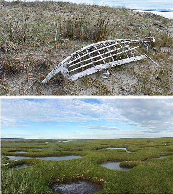
Protection of these coastal resources is of the highest importance for the NPS and is written into the enabling legislation of both western Arctic park units. Relevant to the project at hand, Cape Krusenstern’s enabling legislation includes “to protect habitat for seals and other marine mammals; to protect habitat for, and populations of, birds, and other wildlife, and fish resources; and to protect the viability of subsistence resources.” Enabling legislation for Bering Land Bridge includes “to protect and interpret … coastal formations; … to protect habitat for internationally significant populations of migratory birds; to provide for archaeological and paleontological study, in cooperation with Native Alaskans, of the process of plant and animal migration, including man, between North America and the Asian Continent; to protect habitat for, and populations of, fish and wildlife including, but not limited to, marine mammals; … and to protect the viability of subsistence resources.”
NPS resource managers lack reference condition data to adequately assess potential impacts from marine incidents. This lack of knowledge severely limits the ability of park management to fulfill resource stewardship requirements, including mandated requirements (i.e., enabling legislation, compliance with Endangered Species Act, Migratory Bird Act, Marine Mammal Protection Act, and others) within the designated national preserve and national monument.
Ongoing studies and efforts are quickly filling in many of the gaps. Both parks are actively engaged in learning from local residents and involving them in planning for protection and response. Local communities in this area are extremely interested in all activities that occur in the region, and are willing to participate in ongoing actions that support and protect their homelands. Protection of resources is in the interest of both the communities and the local federal agencies operating in the area; therefore, this is an ideal opportunity to bring all interests together for resource protection throughout the area.
Supporting the understanding of current response plans to marine incidents, and projections of marine traffic in the future, the NPS was able to obtain funding for a project focused on addressing three components of understanding resource risk and incident response preparation.
The three components of this work are field studies of shipping traffic modeling, community response training, and geographic response strategies.
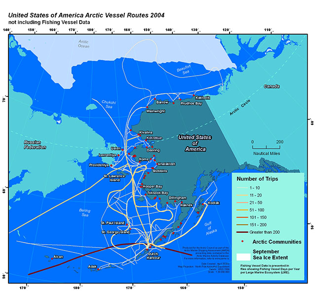
Shipping Traffic Modeling —This project seeks to better understand the risks (and spill threat) associated with projected increases in shipping through the Bering Strait. We are developing a vessel traffic simulation model based on commercially available AIS (Automatic Information System) ship data for ship type, location, and timing through the U.S. Arctic, including the Bering Strait region (Figure 6). Once the simulation model is completed, the model will incorporate assessed projections of future traffic scenarios to understand the projected extent of shipping impact to western Arctic parks.
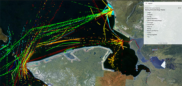
Shipping modeling is under development with several key components completed. The extent of the model includes ships moving through the Aleutians, the Bering Sea, and the Bering Strait. This is important because these are key transit areas to understand how shipping lanes approach the Bering Strait. With the help of the U.S. Fish and Wildlife Service and the Wildlife Conservation Society, we have identified shipping lanes based on AIS data.
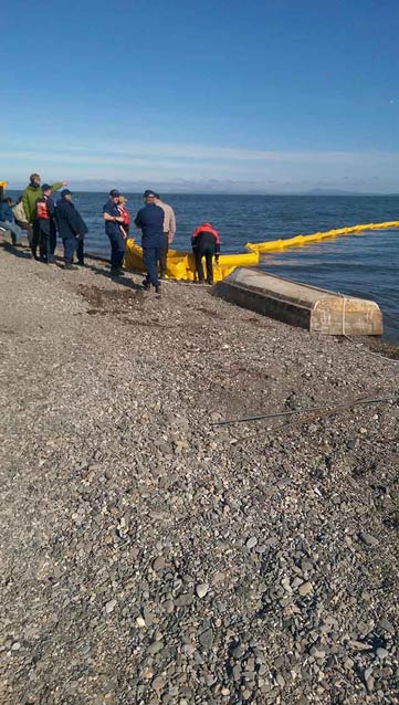
Community Response Training — Community response training includes an introduction to the Incident Command System specifically designed to inform and engage local communities in what would happen in the event a spill response situation in their area. The goal is to enable communities to better prepare for and support large response operations to protect local resources. A HAZWOPER class (Hazardous Waste Operations and Emergency Response) may also be held in conjunction with these trainings to enable more residents to participate in spill response planning. The sessions will also serve as a forum to encourage local boat captains to apply to participate in the USCG’s “Vessel of Opportunity” program, which pays captains for logistical support in a response. The USCG has already conducted training sessions in Nome and Kotzebue focused on the ongoing development of the subarea contingency plans (Figure 7).
Community Response Training — Community response training includes an introduction to the Incident Command System specifically designed to inform and engage local communities in what would happen in the event a spill response situation in their area. The goal is to enable communities to better prepare for and support large response operations to protect local resources. A HAZWOPER class (Hazardous Waste Operations and Emergency Response) may also be held in conjunction with these trainings to enable more residents to participate in spill response planning. The sessions will also serve as a forum to encourage local boat captains to apply to participate in the USCG’s “Vessel of Opportunity” program, which pays captains for logistical support in a response. The USCG has already conducted training sessions in Nome and Kotzebue focused on the ongoing development of the subarea contingency plans (Figure 7).
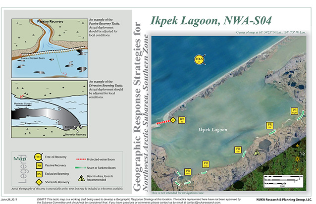
Geographic Response Strategies — ADEC and USCG oversee Geographic Response Strategy (GRS) development to protect sensitive areas in the event of a spill (Figure 8). These strategies detail tactical response operation (e.g., booms, skimmers) recommendations likely appropriate on a fine scale within the sensitive area. Our project assesses the physical limitations for implementation of current GRSs within Bering Land Bridge and Cape Krusenstern, and some of the physical dynamics of the system including the water velocities and bathymetry of the GRS locations and the surrounding areas (Figure 8). Surrounding areas are surveyed to generate documentation of physical dynamics in the event that recommendations for alterations to the Geographic Response Strategies are required. This information will be given to ADEC and USCG to use for consideration in revising the local GRSs. The ultimate management objective is to collect the data required to determine necessary updates to the GRSs to better protect the parks from a spill.
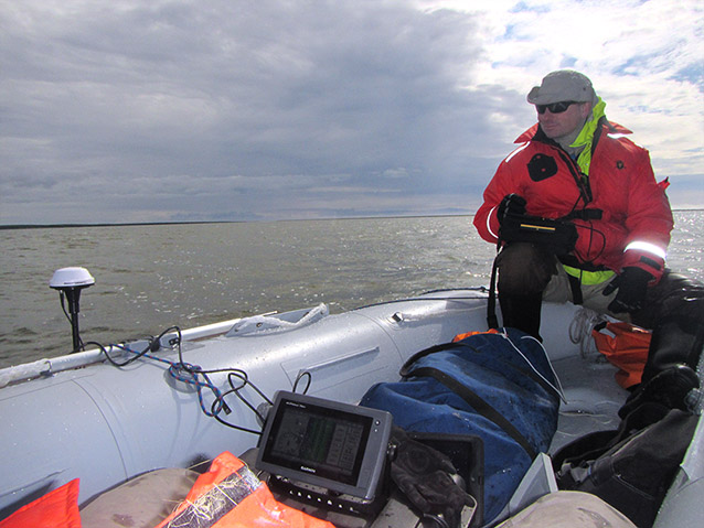
We conducted GRS physical limitations studies in three GRS sites in each park (Bering Land Bridge and Cape Krusenstern) in July 2015, with additional sites planned in 2016. Cape Krusenstern sites included Jade Creek, Tukrok River, and Aukulak Lagoon (Figure 9). An overflight in June 2015 confirmed that several of the lagoons had their outlets closed to the ocean by winter storms. This is a relatively common occurrence, but it did prevent the team from surveying at these sites. We found that Aukulak Lagoon, the only lagoon in Cape Krusenstern surveyed for flow and bathymetry, was relatively shallow (less than 1.09 yards [1 meter]) over the vast majority of the area. From a response standpoint, operations in this area would require a vessel with a very shallow draft. Additionally, access to the site in the back of the lagoon is in water that is approximately 1 foot (0.3 meters) in depth. This shallow water would require additional consideration to access in a response.
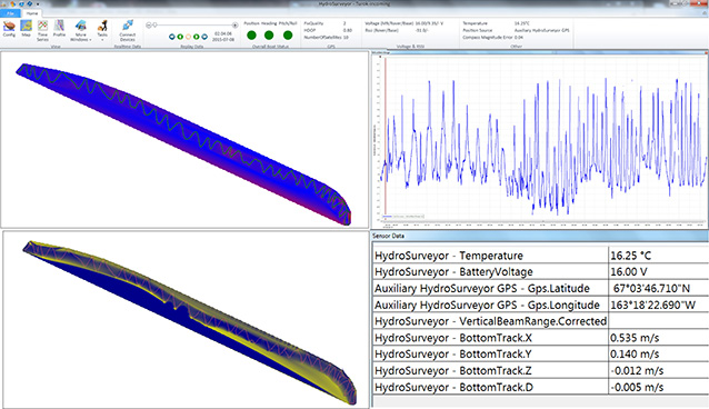
The sites in Bering Land Bridge were different in form, but still present significant physical limitations. Sites surveyed in the preserve included the Goodhope River, Kitluk River, Lane River, Kupik Lagoon, and Ikpek Lagoon (Figure 10). We found the offshore areas were extremely shallow and require some degree of knowledge to safely approach the coast without grounding the vessel. Low tide in the nearshore area of Goodhope River was frequently less than 1.5 feet (0.5 meters), and, while not specifically measured, there was a barrier sand bar offshore from the Espenberg River that was less than 1 foot (0.3 meters) deep (instrumentation does not accurately measure depths less than 1 foot depth). Equally challenging was the interior of Kupik Lagoon. Tactical strategies in the back of the lagoon are surrounded by extremely shallow waters of 1 to 1.5 feet (0.3 to 0.5 meters) in depth, as are the approaches to these areas. The inlet of the lagoon, while much deeper, produces high water velocities that would need to be considered in the event of boom deployment.

As the western Arctic parks continue to address concerns regarding the changes coming to the Arctic, coastal concerns remain high on the radar. With these remote areas and the limited resources available, concern about how to best prepare for a marine incident remains prominent. By updating the geographic response strategies, there is hope that precious time will be saved by avoiding the deployment of vessels into unworkable environments and by incorporating tactics designed around the physical dynamics of these systems. While the GRS of any given area is not an exact prescription for how to respond, it does provide an excellent blueprint to shape strategic thinking, and the more effective this blueprint is, the more efficient and effective our response efforts can be. Furthermore, the development of traffic simulations will aid park managers in visualizing the projections of increasing vessel traffic. Finally, spreading information about how responses are structured will strengthen the local capacity to support a response operation, ultimately protecting these unique and vulnerable places.

References
Alaska Chaddux. 2015.
www.chaddux.com.
Arctic Council. 2009.
Arctic Marine Shipping Assessment 2009 Report.
5.5. Bering Strait Region Case Study. Arctic Council. http://www.pame.is/images/03_Projects/AMSA/AMSA_Background_Research_Docs/Scenarios/5.5-Bering-Strait-Region-Case-Study.pdf.
Aurand, D. and L. Essex. 2012.
Ecological Risk Assessment: Consensus Workshop. Environmental Tradeoffs Associated With Oil Spill Response Technologies. Northwest Arctic Alaska. A report to the US Coast Guard, Sector Anchorage. Ecosystem Management & Associates, Inc., Lusby, MD. 20657. Technical Report 12-01, 54 pages.
Azzara, A., H. Wang, and D. Rutherford. 2015.
A 10-year projection of maritime activity in the U.S. Arctic region. A report to the U.S. Committee on the Marine Transportation System. The International Council on Clean Transportation, Washington D.C. 20005. Contract DTMA91P140125.
United States Committee on the Marine Transportation System (US CMTS). 2013.
U.S. Arctic Marine Transportation System: Overview and priorities for action. Committee on the Marine Transportation System, Washington D.C. 20005.
Part of a series of articles titled Alaska Park Science - Volume 15 Issue 1: Coastal Research Science in Alaska's National Parks.
Last updated: November 18, 2016
