Part of a series of articles titled Intermountain Park Science 2021.
Article • Intermountain Park Science 2021
Finding the Horse Creek Treaty of 1851 Site: An Interdisciplinary Approach to National Historic Landmark Designation
- Zara Hickman, GIS Specialist/Research Associate III CESU Partner, Colorado State University (currently Open Space Coordinator/Natural Resource Specialist, Breckenridge, Colorado)
- Skylar Bauer, Archeologist, Heritage Partnerships Program, National Park Service
- William Tallbull, Management Analyst, Heritage Partnerships Program, National Park Service
- Dena Sanford, Architectural Historian, Historic Preservation Partnerships, National Park Service
Introduction
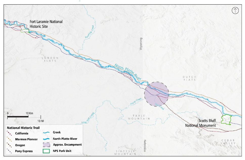
In September 1851, the United States and Northern Plains tribes gathered for a treaty council approximately 35 miles east of Fort Laramie (which is now part of Fort Laramie National Historic Site), near the Horse Creek and North Platte River confluence in what is now western Nebraska. Considered the largest gathering of Plains Indians in U.S. history, the venue was moved from Fort Laramie to a place that could better accommodate the estimated 10,000 Northern Plains American Indians present. According to DaMallie (1980), the treaty council attracted ten bands of Sioux, as well as Cheyennes, Arapahoes, Crows, Shoshones, Assiniboines, Arikaras, Mandans, and Gros Ventres, whom DeMallie identifies as Hidatsa. The Sioux comprised three divisions – the eastern Sioux (four bands known collectively as the Santee, or Dakota); the middle Sioux (the Yankton and Yanktonai, or Nakota); and the western Sioux (the Lakota or Teton). Delegations representing eight of these nine Nations signed the treaty. Today, 25 federally recognized Nations are associated with the 1851 Horse Creek Treaty. The treaty’s overall intent was to discuss territories, passage of non-natives through the area, and annual annuities to compensate American Indians for their loss of land and natural resources (Figure 1).

The National Park Service and its partners are undertaking an interdisciplinary approach to researching the National Historic Landmark eligibility of the 1851 Horse Creek Treaty site. The Horse Creek Treaty is nationally significant for its role in shaping the political landscape and westward migration into American Indian homelands. National Historic Landmarks (NHL) are historic places that possess exceptional historic value to the United States. These sites hold the highest level of honorific designation for a historic property. Before a formal nomination is prepared, a preliminary review is conducted by National Park Service (NPS) regional NHL programs to address significance (the historic importance of the property) and integrity (the physical ability of a property to convey its significance). This article presents a summary of the preliminary review for considering the Horse Creek Treaty site as an NHL. An innovative process was undertaken by NPS staff from multiple offices and regions. As part of evaluating the property’s integrity, the initial step was to confirm the site’s location and size, necessary in defining a potential NHL boundary. Today the National Park Service and its partners are seeking the exact location of the Horse Creek Treaty site (also known as the 1851 Fort Laramie Treaty) and encampment area. Involving regional cultural resources and geographic resources division staff from Department of Interior (DOI) unified Regions 3, 4, 5, 6, 7, and 8, this article highlights the interdisciplinary approaches used thus far to locate the Horse Creek Treaty site. A subsequent article will explore the progress and outcomes of the NPS assessment for the site’s NHL eligibility, and the importance of the site to different cultures.
Locating the Horse Creek Treaty Site
The federal government asked tribes to convene at Fort Laramie for a “Great Smoke” intended “for the permanent good of the Indians” (VanDevelder 2009). However, limited resources at Fort Laramie and the delayed wagon train bearing gifts for the tribes inspired a change in venue.

Image recreated from Nation to Nation: Treaties between the United States and American Indian Nations (Harjo 2014). (Courtesy of National Museum of the American Indian, Smithsonian Institution).
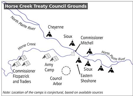
The Northern Plains tribes selected the mouth of Horse Creek, which flows into the North Platte River in Nebraska (Hafen 1973:289). Knowledge of events at the subsequent gathering in September 1851 are drawn from numerous eyewitness accounts from non-native people. The location was an appropriate campground, Dragoon Lowe wrote, “because of more room, grass, and water” and Indian camps “could spread out” (Lowe 1906:84). Descriptions of the council were published in the Missouri Republican (1851), a St. Louis-headquartered newspaper. Other accounts include official reports submitted to the Commissioner of Indian Affairs by treaty commissioners and personal written accounts by Jesuit missionaries (see Chittenden and Richardson 1905; Lowe 1906; Hafen 1973). Their accounts describe the relative location of the treaty ground and its layout (Figure 2).
Quesenbury Sketch and GIS Applications
Absent from accounts of the Horse Creek Treaty gathering is the extent of the sprawling encampment. Chambers reported “about one thousand lodges encamped around us, and several delegations who are without lodges”, however, not described was the camp’s acreage, or the directions it extended (Missouri Republican, October 1, 1851). Fortunately, a historic sketch of the immense camp (Figure 3) has left several clues as to the treaty area, and the surrounding landscape.

(Nebraska State Historical Society, Quesenbury Sketchbook Museum # 8983-5 and Scan number 19126) (Courtesy of History Nebraska, Nebraska State Historical Society).
Artist William Quesenbury, commissioned to illustrate scenery of the West, happened upon the Horse Creek Treaty grounds and quickly sketched the event on September 19, 1851. Although the sketch is rudimentary in comparison to his more comprehensive body of work, its slight topographic characteristics, waterways, and teepee clusters have provided new and exciting insights into this event. The sketch’s simplicity also raises the question of Quesenbury’s vantage point location. This information is invaluable to the NHL process.
Through the use of Geographic Information Systems (GIS), NPS staff were able to revisit Quesenbury’s sketch in ways that yielded potential locations of its vantage point. Using Esri ArcGIS Pro software inside a 3D environment, an interactive viewshed analysis was used to determine locations around the North Platte River and Horse Creek confluence that resembled the sketch. Viewsheds determine what landscape features are visible and non-visible using a digital elevation model. After changing the viewshed tool variables, one point yielded a similar landscape. Importantly, while the viewshed looked remarkably like the sketch, there was a distinct difference from an originally presumed location. Instead it identified the Horse Creek and Owl Creek confluence, approximately 1.5 miles southeast. The 3D landscape was further explored to identify potential landforms that resembled the distinctive ‘notch’ on the left-side of the sketch’s horizon. The potential landforms that were identified all occur on or around one specific bluff formation, which occurs in part within the Scotts Bluff National Monument boundary. The viewshed scene was overlaid with the original Quesenbury sketch for further verification.

While the similarity between Quesenbury’s sketch and the viewshed overlay (Figure 4) is exciting, it is important to remember that it is the result of one type of interpretive method. Additional factors must be considered to increase the confidence in this potential new sketch vantage point location. For example, the treaty was signed in September, a time of year known for infrequent but severe rain events (Perry and Combs 1999). If this is true, the North Platte could have potentially overflowed its boundaries, making the area along its banks muddy and marshy. Such a high-volume encampment on marshy grounds would not have been ideal. An encampment nearby would have been beneficial for tribal members while allowing livestock to graze closer to the North Platte River. Further support for this vantage point is the proximity to the emigrant trails that followed the south side of the North Platte in this area. Quesenbury was documented to be traveling east on either the California or Oregon Trail. The 800’ tall formation of Scotts Bluff was a distinct navigational landmark for travelers of many cultures. On a clear day, the topographic formation would have been visible on the horizon providing a landscape like that rendered by the Quesenbury sketch and the GIS viewshed overlay. The viewshed environment further strengthened evidence that this was the sketch vantage location.
Determining Site Integrity and Event Boundaries
For NHL designation, a property must retain a high degree of integrity in seven aspects: location, design, setting, materials, workmanship, feeling, and association. For the Horse Creek Treaty Site, its physical environment and characteristics of the location where the treaty was signed are still present and intact. Topographic elements such as landscape formation, vegetation, and overall viewshed have remained essentially the same from the historic period to present. These unchanged features are able to convey direct associations with an understanding of the events associated with the treaty council.
The landscape of the Horse Creek Treaty site has evolved since 1851, and today is a dynamic rural landscape exposed to regular flooding, plowing, agricultural practices, and grazing along the North Platte River’s scarred floodplain banks. To address the question of integrity, the NPS contracted with a geomorphologist/geoarcheologist and spoke with landowners to create a comprehensive idea of how the landscape has changed over time.
By studying soils, flood reports, maps, and now-abandoned channels, the geomorphologist estimated the location of the treaty signing and identified adjacent terraces where buried deposits dating to the 1851 treaty event may exist (Eckerle and Taddie 2017). The study found today’s Horse Creek-North Platte River confluence is likely near the historic confluence (a more exact location is withheld due to private property concerns). This report indicates that the historic confluence likely washed away from a flood in 1929. There is a possibility that intact cultural remains exist beyond the floodplain. This theory is substantiated by private artifact collections. The geomorphological findings provide additional insight to understanding the council attendees’ true impact to the landscape. These findings suggested that the treaty council attendees occupied over 35,220 acres, an extent necessary to sustain the estimated 20,000 horses present (Eckerle and Taddie 2017). This estimate supports firsthand accounts of a heavily-used landscape that by the end of the event, included a council site that had been “eaten out” of grass, and a larger prairie area that resembled “an arid plain,” with dust rising in immense clouds “with every gust of wind.” The air had become so “offensive in many respects” that Mitchell’s military court moved its camp down the Platte a few days before the treaty signing (Missouri Republican, November 30, 1851). It is likely that other camps also relocated, further expanding the site boundaries well beyond the initial encampment.
Establishing a Balanced Statement of National Significance
The Horse Creek Treaty is nationally significant for its role in shaping the political landscape and westward migration into American Indian homelands. As the treaty proceedings were extensively documented in the Missouri Republican, the general features of the council (ritual aspects, demands, requests, and distribution of presents) suggest a “minimal model” that would have been familiar to U.S. treaty commissioners authorized to organize other Plains treaty councils (DeMallie 1980).

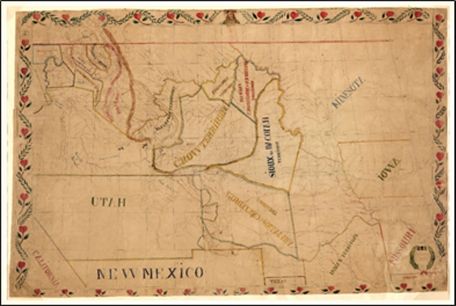
[De Smet, P.-J. 1851. Map of the upper Great Plains and Rocky Mountain region. Available at: https://www.loc.gov/item/2005630226/ (accessed February 12, 2021)
The treaty is also important for the boundary map drawn during the council proceedings (Figure 5). For the first time a government map delineated tribal territories for American Indian nations of the Great Plains, indicating that the U.S. had agreed “in principle” to land reserved for these groups. At the time, the boundaries were meaningless to tribes as they continued to move across the ascribed territories. Yet this boundary map can be seen as a key first step by the U.S. government in establishing reservations for these Plains tribes that was used in later treaty negotiations (Trennert 1975:191).

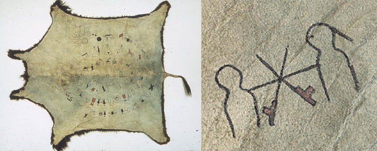
(Manuscripts 2372: Box 12, National Anthropological Archives, Smithsonian Institution). (Courtesy of National Museum of the American Indian, Smithsonian Institution (1/617). Photo by NMAI Photo Services).
While the Missouri Republican and personal accounts are valuable resources to understand the treaty proceedings, they represent a biased Eurocentric view. Lakota winter counts (pictorial records of history documenting important events) help to understand the importance of this treaty to tribes. The Smithsonian’s National Anthropological Archives and National Museum of Natural History created an online exhibit which featured several counts related to the Horse Creek Treaty (Figure 6). Many goods were distributed at the treaty that some 1851-52 winter counts referred to it as the Winter of the Big Distribution, designated “by a pile of trade goods, topped with blankets” (Stands in Timber and Liberty 1998).
Continuing Efforts
Determining the eligibility of the Horse Creek Treaty site as a National Historic Landmark is an ongoing process. Most importantly this effort aspires to document a balanced narrative of the events that occurred in 1851. With the use of visuals and additional GIS application products the NPS hopes to record traditional cultural knowledge and the American Indian perspective through oral histories. When these applications and visual cues are used in interviews, they can prompt memories and stories. Oral histories recorded thus far have already refined previously documented treaty locations (in Figure 2) and defined the site’s significance from multiple cultural perspectives. The second article in this series will discuss the outcomes of the oral histories and the historical truths they convey.
While the 1851 Horse Creek Treaty site research continues, it illustrates the value of partnerships and collaborations across disciplines. Multiple programs from several DOI regions intend to continue working with traditionally associated tribes to represent a balanced account of treaty events in a respectful, supportive, and inclusive manner. The honorific designation of the site as an NHL would recognize the site’s importance in the story of westward migration and its impacts on American Indians. In addition to educating the public on this often overlooked event, an NHL designation could inspire others to learn more about the intent and effect of treaties between the U.S. Government and American Indian tribes. The diverse, interdisciplinary approach to researching the NHL eligibility of the Horse Creek Treaty fulfills the NPS mission of preservation and stewardship in new and creative ways. For additional information on the NHL program, please visit National Historic Landmarks Program (U.S. National Park Service) (Available at https://www.nps.gov/orgs/1582/index.htm; accessed March 3, 2021).
References
Chittenden, H. M., and A. T. Richardson, editors. 1905.
Life, Letters and Travels of Father Pierre-Jean DeSmet, S.J., 1801-1873. Vol. II. Francis P. Harper, 392 pp.
DeMallie, R. 1980.
Touching the Pen. Pages 38-53 in F. C. Luebke, editor. Ethnicity on the Great Plains, University of Nebraska Press, Lincoln, Nebraska.
Eckerle, W., and S. Taddie. 2017.
Geoarchaeological investigation of the AD 1851 Horse Creek Treaty site. Western GeoArch Research, LLC Unpublished Report, Driggs, Idaho.
Hafen, L. 1973.
Broken Hand: The Life of Thomas Fitzpatrick: Mountain Man, Guide and Indian Agent. University of Nebraska Press, 359 pp.
Harjo, S. editor. 2014.
Nation to Nation: Treaties between the United States and American Indian Nations. Smithsonian Books, 272 pp.
Lowe, P. G. 1906.
Five Years a Dragoon (‘49 to ‘54) and Other Adventures on the Great Plains. F. Hudson Publishing Company, 417 pp.
Missouri Republican, August-November 1851.
St. Louis, Missouri.
Perry, C. A., and L. J. Combs. 1999.
Summary of floods in the United States, January 1992 through September 1993. U.S. Geological Survey Water Supply Paper 2499.
Stands in Timber, J., and M. Liberty 1998.
Cheyenne Memories. University of Nebraska Press, 330 pp.
Trennert, R. A., Jr. 1975.
Alternative to Extinction: Federal Indian Policy and the Beginnings of the Reservation System 1846-1851. Temple University Press, 263 pp.
VanDevelder, P. 2009.
Savages and Scoundrels: The Great Treaty at Horse Creek and the Making of America. Yale University Press, 352 pp.
Last updated: September 13, 2021


