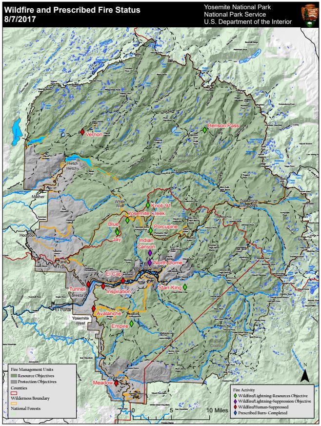
Discovered: 8/1/17
Location: N 37° 38.673' x W 119° 37.096' at roughly 7300 feet elevation
Size: 850 acres
Cause: Lightning
Spread Potential: Moderate
Fuels: Red fir
Strategy: Monitor
County: Mariposa
The Empire Fire is burning in wilderness and poses no current threat to park infrastructure. It was reported on the night of July 31st. This fire is being managed to meet both protection and resource management objectives as allowed in Yosemite's Fire Management Plan. It is approximately 1 mile south of Bridalveil Campground and between Alder Creek drainage and Bridalveil Creek drainage. Fire crews are monitoring growth, fire behavior, and smoke dispersion. Daily fire growth is expected to range from 50-100 acres. The fire is burning in heavy pockets of dead and down timber which reduces fuels buildup and increases forest resiliency. Trails are closed from Bridalveil Creek Campground to the second junction with the Ostrander trail and from Westfall Meadow to the Deer Camp junction, along Alder Creek. There are no threats to infrastructure at Bridalveil Campground and the remainder of hiking trails in the area are open at this time. Future closures will be decided based on fire behavior.
Knob 91
Discovered: 8/4/17
Location:N 37° 52.185' x W 119° 35.217' at approximately 8980 feet elevation
Size: .39 acres
Cause: Lightning
Spread Potential: Low
Fuels: Timber litter
Strategy: Monitor
County: Mariposa
Yosemite Creek
Discovered: 8/3/17 Location: N 37° 50.414' x W 119° 38.088' at approximately 7,970 feet elevation
Size: less than one quarter acre
Cause: Lightning
Spread Potential: Moderate
Fuels: Red fir
Strategy: Monitor
County: Mariposa
Blue
Discovered: 8/2/17
Location: Blue Jay Creek drainage at approximately 8,715 feet elevation
Size: less than one quarter acre
Cause: Lightning
Spread Potential: Low
Fuels: Mountain hemlock/Jeffrey pine
Strategy: Monitor
County: Tuolumne
Jay
Discovered: 8/2/17
Location: In the Blue Jay Creek drainage at approximately 8653 feet elevation
Size: less than one quarter acre
Cause: Lightning
Spread Potential: Low
Fuels: Mountain hemlock/Jeffrey pine
Strategy: Monitor
County: Tuolumne
Porcupine
Discovered: 8/2/17 Location: N 37° 49.336' x W 119° 34.720' at approximately 8154 feet elevation off Tioga road near Yosemite Creek Campground road
Size: 1.32
Cause: Lightning Spread
Potential: Low
Fuels: Lodgepole/Red fir
Strategy: Monitor
County: Mariposa
Starr King
Discovered: 8/2/17 Location: N 37° 42.965' x W 119° 29.588' at approximately 7800 feet elevation
Size: 3 acres
Cause: Lightning Spread
Potential: Moderate
Fuels: Red fir/ Lodgepole
Strategy: Monitor
County: Mariposa