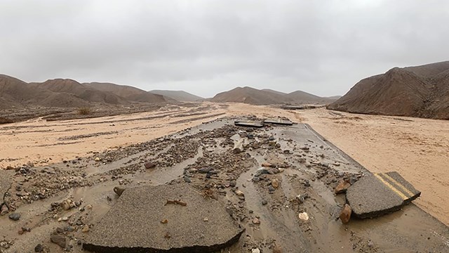
Superintendent Mike Reynolds demonstrates significant damage on Lower Wildrose Road, caused by flooding on August 20, 2023.
NPS
PAVED ROADS
CAUTION:
CA 190 - Expect delays up to 20 min along CA 190 as Caltrans installs gabion structures to reduce the risk of road damage during flooding.
Paved roads parkwide (other than CA 190): Contruction will be in progress November 4, 2024 through early April 2025. Expect traffic control delays.
CLOSED:
Bonnie Clare Road and Scotty’s Castle due to flood recovery work. Unlikely to open beforelate 2025. No access permitted. No foot, bicycle, motorcycle, vehicle, etc. use allowed.
Emigrant Canyon Road: Will have an extensive closure beginning mid to late November 2024 through early April 2025, but we don't know the dates yet. Check back later for updates. When that is closed, it will be closed to all public entry, including bicycles and pedestrians.
Harmony Borax Works: Closed 11/22 & 11/23 for trail repair work. Additional repair work and closures will occur in December 2024 (dates not yet determined). Closure is to all public entry, including bicycles and pedestrians.
UNPAVED/BACKCOUNTRY ROADS
CAUTION:
Harry Wade Road has deep sand on the north end close to mile 6.
CLOSED:
Note that road closures listed below apply to ALL motorized vehicles, including motorcycles.The roads were completely washed out in places and entry will cause tire tracks and braided roads in wilderness as users try to locate what was once the road. Thank you for your patience as we work to reopen these locations. Bicycles are permitted except on Titus Canyon Rd.
Only major roads are listed for reference below:
Northern entrance of West Side Road - Due to a deep cut in the road. Construction starts November 4, 2024.
Lower Wildrose Road (aka Trona - Wildrose Road, connects Wildrose to Panamint Valley)- completely impassable due to a 9-foot deep cut across the road. Likely to remain closed until Summer 2026.
Darwin Falls - Road is completely gone in many places. It will need either extensive import of road fill (expensive) or "mining" of gravel from the nearby wash (this would require thorough environmental review). Likely to remain closed until Summer 2026. Hikers can park on the shoulder of CA-190 and walk in.
Salt Creek - Flooding destroyed the boardwalk, restroom and parking area. Will not open before June 2025.
Titus Canyon Road - Due to flood damage. Bicycle use is prohibited in Titus Canyon for safety reasons. Impassable. Not likely to open before 2026. Lower Titus Canyon to the Fall Canyon Trailhead is open.
Cottonwood CanyonRoad- Closed final 1.6 miles due to water.
All campgrounds except Furnace Creek Campground are first come first served year-round.
OPEN:
Furnace Creek (first come first served 4/15-10/14, reservation 10/15-4/14)
Texas Springs
Sunset
Stovepipe Wells
Mesquite Spring
Emigrant
Wildrose (will be closed sometime between November 2024 through April 2025 due to road construction on Emigrant Canyon Road. Check back later for updates.)
Thorndike Primitive (will be closed sometime between November 2024 through April 2025 due to road construction on Emigrant Canyon Road. Check back later for updates.)
Mahogany Flat Primitive (will be closed sometime between November 2024 through April 2025 due to road construction on Emigrant Canyon Road. Check back later for updates.)